 Catalogue PIGMA
Chemical oceanography
Type of resources
Available actions
Topics
Keywords
Contact for the resource
Provided by
Years
Formats
-
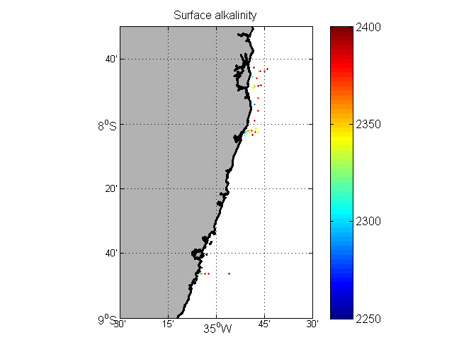
Inorganic carbon and alkalinity measurements (in micromoles/kg) along the coast of Brazil, 2013-2015.
-
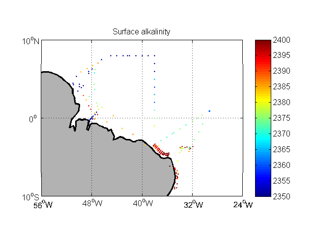
Inorganic carbon and alkalinity measurements (in micromoles/kg) from Brazilian cruises in the Western Tropical Atlantic.
-
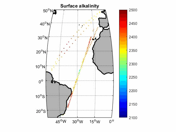
Carbon parameters along the track of merchant ships
-
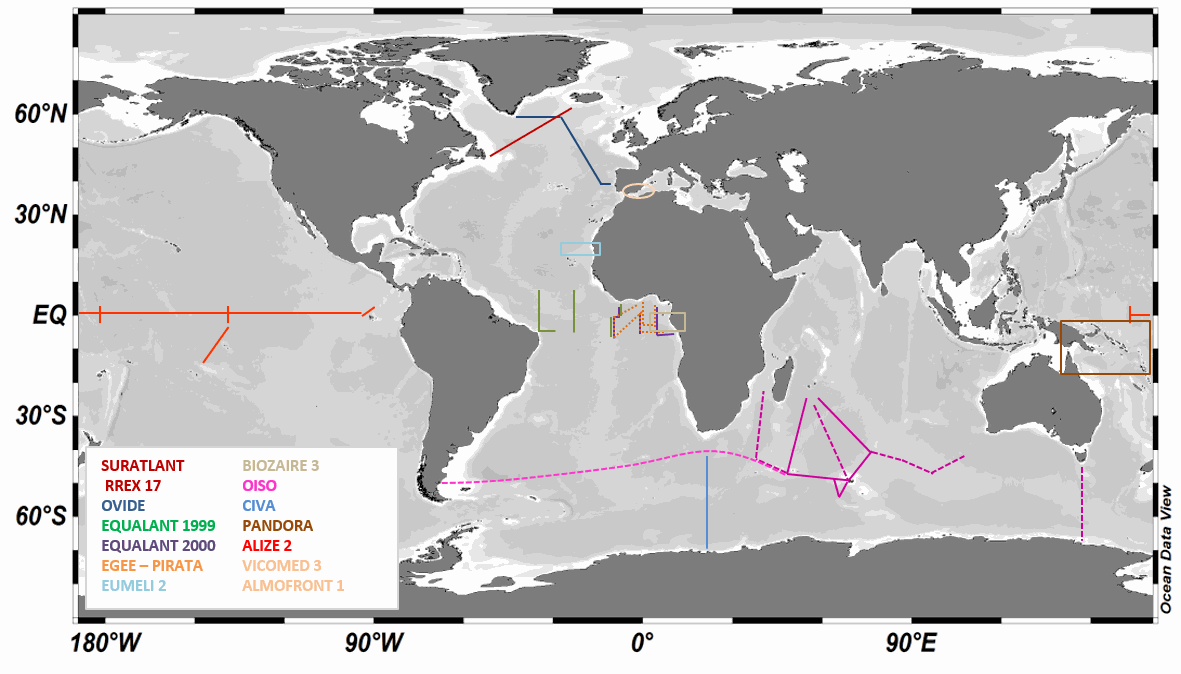
LOCEAN has been in charge of analyzing the isotopic composition of the dissolved inorganic carbon (DIC) in sea water collected during a series of cruises or ships of opportunity mostly in the southern Indian Ocean , the North Atlantic, and the equatorial Atlantic, but also in the Mediterranean Sea and in the equatorial Pacific. The LOCEAN sea-water samples for δ13CDIC were collected in 125/25 ml glass bottles until 2022/since then and poisoned with HgCl2 (1 ml of saturated solution) before storage in a dark room à 4°C until their measurement. The DIC was extracted from the seawater by acidification with phosphoric acid (H3PO4 85%) and CO2 gas that was produced was collected in a vacuum system following the procedure described by Kroopnick (1974). The isotopic composition of CO2 was determined using a dual inlet-isotopic ratio mass spectrometer (SIRA9-VG) by comparing the 13C/12C ratio of the sample to the 13C/12C ratio of a reference material, the Vienna-Pee Dee Belemnite (V-PDB). The isotopic composition is expressed in the δ-unit defined by Craig (1957)(method type 2). Experience showed that samples older than 3-4 years are likely to have experienced conservation issues and have been dismissed. The mass spectrometer has worked very well until 2014-2015. Afterwards, its aging as well as the aging of the preparation line resulted in more data loss, and often less accurate results. The preparation line was renovated in 2019, and analyses in 2020 were run manually, often repeating the measurement a second time for each sample. Up to 2007-2008, δ13CDIC values have a precision of±0.01 ‰ (Vangriesheim et al.,2009) and a reproducibility of±0.02 ‰. After an interlaboratory comparison exercise led by Claire Normandeau (Dalhousie University), results suggest that recent LOCEAN samples have a slightly poorer reproducibility (±0.04 ‰ ) as well as an offset of -0.13‰ (details available in Reverdin et al., ESSD 2018) that is confirmed by Becker et al. 2016 work by comparison with other cruises after removing the anthropogenic signal. Recent comparisons in early May 2021 with Orsay GEOPS facility samples suggest that the current offset is much smaller and might be +0.03‰. LOCEAN has installed in 2021 a new measurement device by coupling a Picarro G2131-I cavity ring down spectrometer (CRDS) with a CO2 extractor (Apollo SciTech) that will measure at the same time DIC (method type 3) (Leseurre, 2022). Since then, all water samples have been analyzed on this device. Part of the data set, as well as a scientific context and publications are also presented on the WEB site https://www.locean-ipsl.upmc.fr/oceans13c. Individual files correspond to regional subsets of the whole dataset. The file names are based on two letters for the region followed by (-) the cruise or project name (see below) followed by –DICisotopes, followed by either -s (surface data) or -b (subsurface data), and a version number (-V0, …): example SI-OISO-DICisotopes-s-V0; the highest version number corresponds to the latest update of the cruise/project data set, and can be directly downloaded. Earlier versions can be obtained on request, but are not recommended. The region two letters are the followings: - SI: station and surface data in the Southern Indian Ocean that include cruises : INDIGO I (1985 – stn) (https://doi.org/10.17600/85000111) CIVA I (1993 – stn & surf) (https://doi.org/10.17600/93000870) (Archambeau et al., JMS 1998) ANTARES (1993 – stn & surf) (https://doi.org/10.17600/93000600) OISO (*) (since 1998 – stn & surf) (https://doi.org/10.18142/228) (Racapé et al., Tellus 2010, Leseurre, 2022) - EA: station and surface data in the Tropical Atlantic Ocean that include cruises : EQUALANT (1999 & 2000 – surf) (https://doi.org/10.18142/98) EGEE (2005 to 2007 – stn & surf) (https://doi.org/10.18142/95) PIRATA (since 2013 – stn & surf) (https://doi.org/10.18142/14) EUMELI 2 (1991 – stn) (https://doi.org/10.17600/91004011) (Pierre et al., JMS 1994) BIOZAIRE 3 (2003 – stn & surf ) (https://doi.org/10.17600/3010120) (Vangriesheim et al., DSRII, 2009) TARA-Microbiomes (2021 - stn & surf) - NA : station and surface data in the North Atlantic Subpolar gyre that include cruises : OVIDE (**) (since 2002 – stn & surf) (https://doi.org/10.17882/46448) (Racapé et al., 2013) RREX (2017 – stn & surf) (https://doi.org/10.17600/17001400) SURATLANT (since 2010 - surf) (https://doi.org/10.17882/54517) (Racapé et al., BG 2014 ; Reverdin et al., ESSD 2018, Leseurre, 2022) NUKATUKUMA (since 2017- surf) - MS: station data in the Mediterranean sea that include cruises : ALMOFRONT 1 (1991 – stn) (https://doi.org/10.17600/91004211) VICOMED 3 (1990 – stn) (https://doi.org/10.17600/90000711) - PO: tropical Pacific that include cruises : PANDORA (2012 – stn) (https://doi.org/10.17600/12010050) ALIZE2 (1991 – stn & surf) (https://doi.org/10.17600/91002711) (Laube-Lenfant and Pierre, Oceanologica Acta 1994) - SO: station and surface data in the Southern Ocean (except OISO) that include cruises: TARA-Microbiomes (2021-2022, stn & surf) AGULHASII-072022 (2022, stn) CONFLUENCE (1993-1994, stn) - AO: station and surface data in the Arctic Ocean and nearby seas that include cruises: GREENFEEDBACK (2024, stn&surf) TCA (2024, stn) REFUGE ARCTIC (2024, stn) (*) The values for cruises OISO19, 21 and 22 are doubtful (for some, too low) and will require further investigation to find whether adjusted values can be proposed. (**) Some of the OVIDE cruises are also referred to as or GEOVIDE (in 2014), and BOCATS (in 2016). CATARINA, BOCATS1 and BOCATS2 (PID2019-104279GB-C21/AEI/10.13039/501100011033) cruises were funded by the Spanish Research Agency The values of the OVIDE 2010 stations are doubtful (too low), but no particular error was found, and they have been left in the files. Data The files are in csv format reported as: - Cruise name, station id, (bottle number), day, month, year, hour, minute, longitude, latitude, pressure (db), depth (m), temperature (°C), temperature qc, salinity (pss-78), salinity qc, d13CDIC, d13CDIC qc, method type - Temperature is an in situ temperature - Salinity is a practical salinity - Method type (1) acid CO2 extraction from helium stripping technique coupled to mass spectrometer, (2) acid CO2 extraction in a vacuum system coupled to mass spectrometer,(3) CO2 extractor (Apollo SciTech) coupled to CRDS measurements. Temperature qc, salinity qc, d13CDIC qc are quality indices equal to: - 0 no quality check (but presumably good data) - 1 probably good data - 2 good data - 3 probably bad data - 4 certainly bad data - 9 missing data (and the missing data are reported with an unlikely missing value)
-
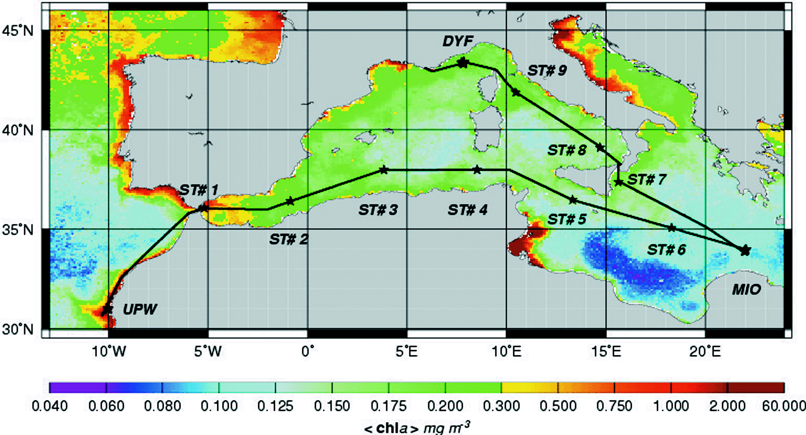
The PROSOPE (PROductivity of Oceanic PElagic Systems) cruise took place from the 4th of September (Agadir, Morocco) to the 4th of October (Toulon, France) 1999 aboard the RV Thalassa. There were four main scientific objectives: 1, carry out classical process studies, typical of the Joint Global Ocean Flux Study (JGOFS), 2, focus on small scale biogeochemical processes, in particular at a daily scale, 3, study the influence of nitrogen, phosphorus and iron on oceanic fertility and 4, conduct a calibration/validation operation for the SeaWIFS (Sea-viewing Wide Field-of-View Sensor) color sensor. To reach these objectives, the studied areas, as well as the cruise plan, were designed : To investigate different trophic regimes, to investigate systems characterized by different degrees of limitation in nitrogen and phosphorus and to study stable ("steady state") systems for a sufficiently long period. The cruise track encompassed a variety of trophic systems ranging from eutrophic conditions associated to the Moroccan upwelling to the typical ultra-oligotrophic conditions of the eastern Mediterranean sea during summer stratification. Two main types of stations were occupied : - 9 short (4-hour) stations. These sites were occupied around the solar noon and were essentially designed to conduct objectives 1 (JGOFS process studies) and 4 (SeaWIFS validation/calibration) - 3 "long" (5-day) stations, where all four objectives were investigated with a particular emphasis on objectives 2 (processes at a daily scale) and 3 (nutrient resources and oceanic fertility). Between each station, continuous multiparametric (hydrological, optical, biological and chemical) surface acquisitions were performed.
-
This product contains observations and gridded files from two up-to-date carbon and biogeochemistry community data products: Surface Ocean Carbon ATlas SOCATv2023 and GLobal Ocean Data Analysis Project GLODAPv2.2023. The SOCATv2023-OBS dataset contains >25 million observations of fugacity of CO2 of the surface global ocean from 1957 to early 2023. The quality control procedures are described in Bakker et al. (2016). These observations form the basis of the gridded products included in SOCATv2023-GRIDDED: monthly, yearly and decadal averages of fCO2 over a 1x1 degree grid over the global ocean, and a 0.25x0.25 degree, monthly average for the coastal ocean. GLODAPv2.2023-OBS contains >1 million observations from individual seawater samples of temperature, salinity, oxygen, nutrients, dissolved inorganic carbon, total alkalinity and pH from 1972 to 2021. These data were subjected to an extensive quality control and bias correction described in Olsen et al. (2020). GLODAPv2-GRIDDED contains global climatologies for temperature, salinity, oxygen, nitrate, phosphate, silicate, dissolved inorganic carbon, total alkalinity and pH over a 1x1 degree horizontal grid and 33 standard depths using the observations from the previous major iteration of GLODAP, GLODAPv2. SOCAT and GLODAP are based on community, largely volunteer efforts, and the data providers will appreciate that those who use the data cite the corresponding articles (see References below) in order to support future sustainability of the data products.
-

REPHYTOX dataset includes long-term time series on phycotoxins in marine bivalve molluscs, since 1987, along the whole French coast. The dataset covers results on lipophilic toxins, PSP toxins, ASP toxins, and palytoxins. REPHYTOX was a full part of the REPHY network until 2015. The whole dataset is available.
-
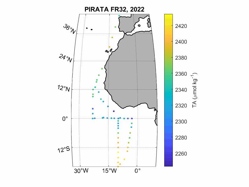
Seawater samples (500 mL) were taken during the PIRATA FR-32 cruise to measure surface inorganic carbon and alkalinity. The analyses were realised by potentiometric titration using a closed-cell at the SNAPO-CO2, LOCEAN in Paris.
-
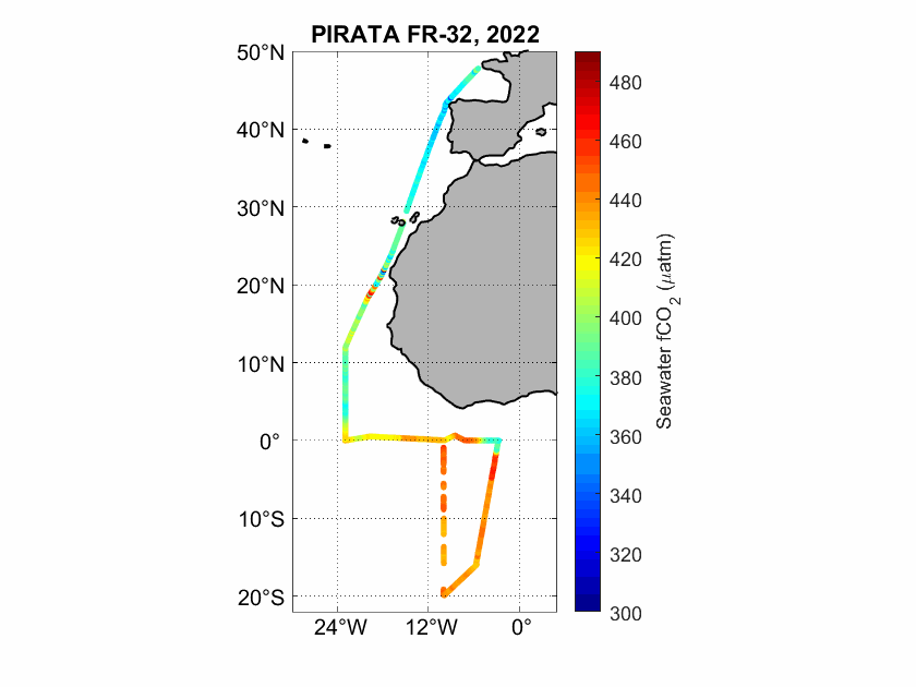
The fugacity of CO2 (fCO2) was measured underway during the PIRATA FR-32 cruise in the Eastern Tropical Atlantic using an infrared detection technique.
-
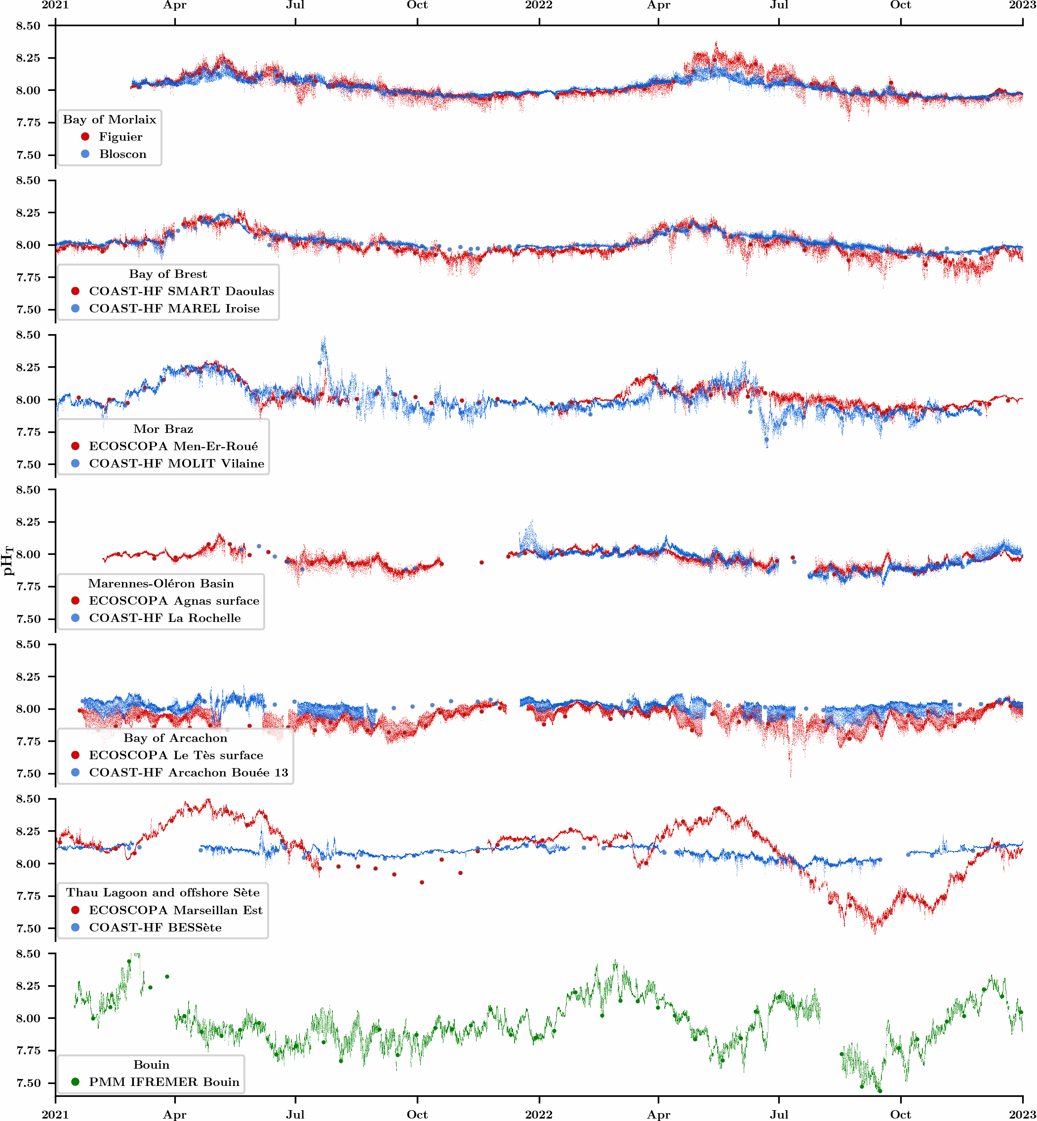
An observation network was initiated in 2021 in the framework of the CocoriCO2 project to monitore carbonate parameters along the French coastal systems. Six sites were selected along the French Atlantic and Mediterranean coastlines based on their importance in terms of shellfish production and the presence of high- and low-frequency monitoring activities. At each site, autonomous pH sensors were deployed both inside and outside shellfish production areas, next to high-frequency CTD (conductivity-temperature-depth) probes operated through two operating monitoring networks (SNO COAST-HF and Ifremer ECOSCOPA). pH sensors were set to an acquisition rate of 15 min and discrete seawater samples were collected biweekly in order to control the quality of pH data (laboratory spectrophotometric measurements) as well as to measure total alkalinity and dissolved inorganic carbon concentrations for full characterization of the carbonate system. While this network has been up and running for more than two years, the acquired dataset has already revealed important differences in terms of pH variations between monitored sites related to the influence of diverse processes (freshwater inputs, tides, temperature, biological processes).