 Catalogue PIGMA
Directive Cadre sur l'Eau (DCE)
Type of resources
Available actions
Topics
Keywords
Contact for the resource
Provided by
Years
Formats
Representation types
Update frequencies
status
Scale
Resolution
-

This data set presents the resulting assessment grid (based on the EEA reference grid) with the classification of chemical status of the transitional, coastal and marine waters in the context of the Water Framework Directive (WFD) and the Marine Strategy Framework Directive (MSFD), providing a mapping of contamination 'problem areas' and 'non-problem areas' based on measurements of biological effects. This classification has been performed using the CHASE+ tool, with classifications of the of contaminant status of indicators of biological effects. The status is evaluated in five classes, where NPAhigh and NPAgood are recognised as ‘non-problem areas’ and PAmoderate, PApoor and PAbad are recognised as ‘problem areas’. Monitoring biological effects is restricted to a few indicators (e.g. imposex) and data coverage is currently limited. Biological effects have thus been addressed in only 134 assessment units, mostly in the Baltic Sea, the North Sea and the North-East Atlantic Ocean. This data set underpins the findings and cartographic representations published in the EEA report “Contaminants in Europe’s seas” (No 25/2018). See the mentioned report for further information.
-
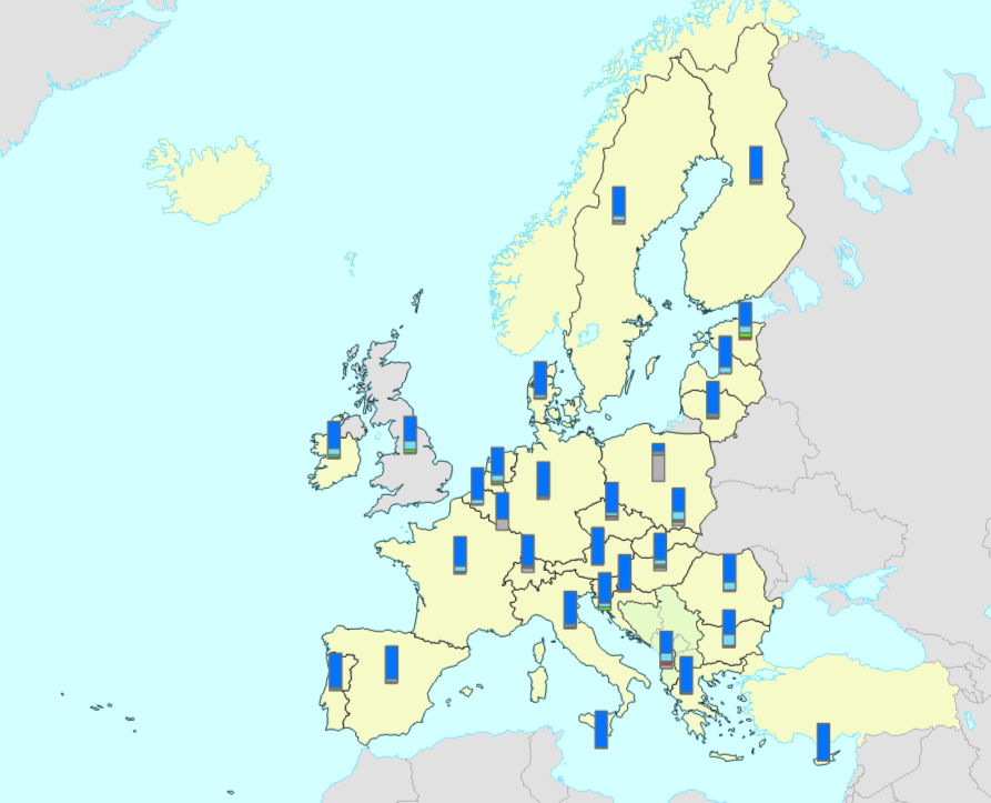
The bathing water quality data services include all coastal and inland bathing waters reported and assessed in the European Union Member States, Albania, Switzerland and the United Kingdom. The data is reported annually in the scope of the Bathing Water Directive (Directive 2006/7/EC of the European Parliament and of the Council of 15 February 2006, BWD) reporting obligations. The map services in https://water.discomap.eea.europa.eu/arcgis/rest/services/BathingWater show the location of the bathing waters and the assessment of bathing water quality for the last reported bathing season, as well as for the ten previous bathing seasons. Each bathing water is assessed for three statuses: 1) monitoring calendar status, 2) management status, 3) bathing water quality status. The monitoring calendar status evaluates the implementation of the monitoring calendar in the last reported season (as defined in Annex IV of the Bathing Water Directive). The management status evaluates the management in the last assessment period, whether the bathing water was continuously monitored or not. The bathing quality status evaluates the quality of bathing waters according to the two microbiological parameters: Escherichia coli and Intestinal enterococci (as defined in Annexes I and II of the Bathing Water Directive). The bathing water quality is classified in one of four classes: “Excellent”, “Good”, “Sufficient” or “Poor”. The status “Not classified” is applied if there are not enough available samples to evaluate the water quality. The data service in https://discodata.eea.europa.eu/ contains the results of the bathing water status since 1990: [WISE_BWD].[latest].[assessment_BathingWaterStatus] It also contains the reported data in the following tables: [WISE_BWD].[latest].[timeseries_Characterisation] [WISE_BWD].[latest].[timeseries_SeasonalPeriod] [WISE_BWD].[latest].[timeseries_MonitoringResult] [WISE_BWD].[latest].[spatial_SpatialProtected]
-
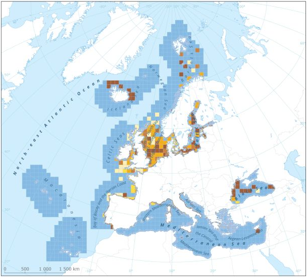
This dataset presents the resulting assessment grid (based on the EEA reference grid) with the classification of chemical status of the transitional, coastal and marine waters in the context of the Water Framework Directive (WFD) and the Marine Strategy Framework Directive (MSFD). This classification has been performed using the CHASE+ tool, with classifications of the matrices ‘water’, ‘sediment’ and ‘biota’ and indicators of ‘biological effects’, as well as an integrated classification of chemical status, combining results of all matrices. The chemical status is evaluated in five classes, where NPAhigh and NPAgood are recognised as ‘non-problem areas’ and PAmoderate, PApoor and PAbad are recognised as ‘problem areas’. This is the assessment made excluding concentrations of mercury (Hg). The overall area of interest used is based on the marine regions and subregions under the Marine Strategy Framework Directive. Additionally, Norwegian (Barent Sea and Norwegian Sea) and Icelandic waters (’Iceland Sea’) have been added (see Surrounding seas of Europe). Note that within the North East Atlantic region only the subregions within EEZ boundaries (~200 nm) have been included. This dataset underpins the findings and cartographic representations published in the report "Contaminants in Europe's Seas" (EEA, 2019).
-
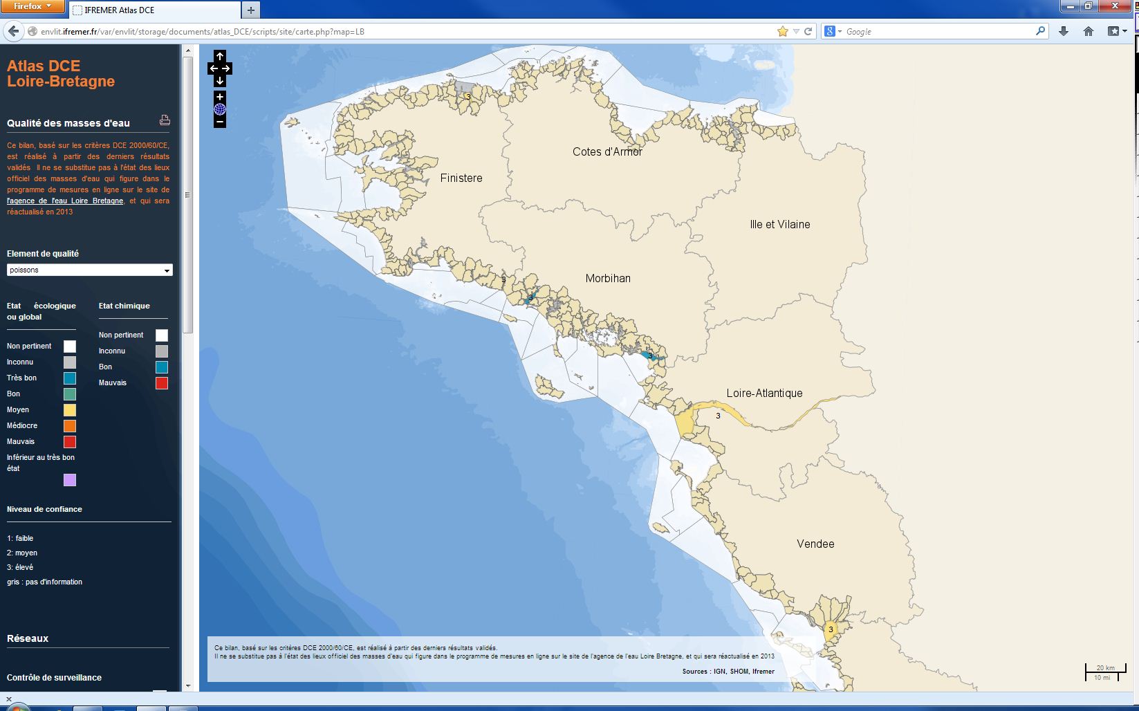
L’analyse porte sur le suivi des populations de poissons dans les seules masses d'eaux de transition de la Manche ouest et du golfe de Gascogne et l'évaluation de leur qualité biologique. L'indicateur poisson ELFI dans les estuaires français associé à cet élément de qualité repose sur : - densité totale de poissons, - densité de poissons diadromes, - densité de juvéniles marins (dans les zones méso. et polyhalines), - densité de poissons d’eau douce (dans les zones oligohalines), - densité d’espèces résidentes, - densité de poissons benthiques, - richesse taxonomique. Les masses d'eau suivies sont échantillonnées deux fois par an, trois années consécutives pour le calcul de l'indicateur. L’évaluation la plus récente est présentée dans l’atlas DCE Loire-Bretagne. Les états antérieurs sont accessibles dans des archives annuelles
-

La température figure parmi les éléments de qualité pour la classification de l'état écologique des masses d’eaux littorales, c’est à dire les masses d’eaux côtières et les masses d’eaux de transition de la Manche ouest et du golfe de Gascogne. Les mesures de température sont effectuées sur site en sub-surface une fois par mois de janvier à décembre. L’indicateur température est défini comme le pourcentage de mesures hors d’une enveloppe considérée comme assurant le bon fonctionnement écologique de l’écosystème. Il permet un classement en deux états : bon ou mauvais. L’évaluation la plus récente de l’état de cet élément est présentée dans l’atlas DCE Loire-Bretagne. Les états antérieurs sont accessibles dans des archives annuelles.
-
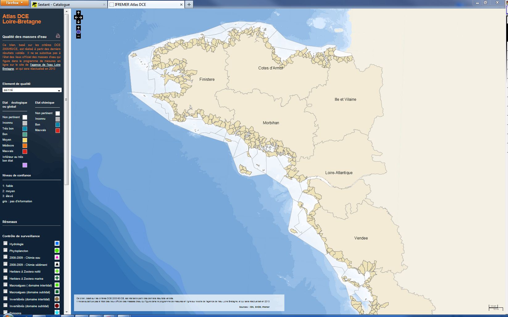
De brutales variations de salinité, intenses et répétées, peuvent être nuisibles au bon fonctionnement des organismes marins. Toutefois, les prélèvements mensuels tels que prescrits par la DCE ne permettent pas de suivre la durée et la fréquence d'éventuelles dessalures. L'indicateur de qualité salinité a donc été déclaré non pertinent par les experts dans les masses d'eau côtières et de transition dans le cadre du programme de surveillance DCE. Néanmoins, ce paramètre est mesuré systématiquement lors des sorties en mer, afin d'appuyer l'interprétation des autres paramètres hydrologiques (nutriments et oxygène dissous) et biologiques.
-
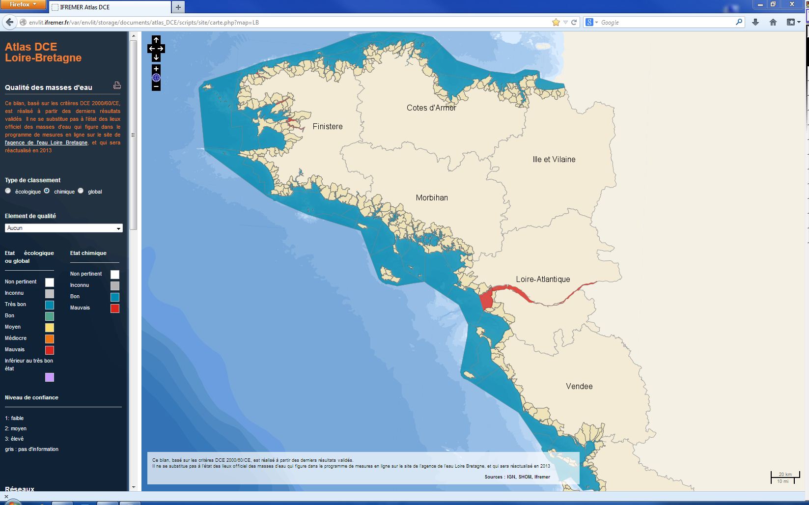
L’évaluation de l'état chimique de la masse d’eau repose sur deux Normes de Qualité Environnementale (NQE) établies pour chaque substance ou groupe de substances dans la directive 2008/105/CE. Ces normes représentent des seuils à ne pas dépasser afin de protéger l’environnement et la santé humaine : - La NQE-CMA : qui représente la Concentration Maximale Admissible (μg/L) ; - La NQE-MA : qui présente la Concentration Moyenne Annuelle à ne pas dépasser (μg/L). L’état chimique est défini par 2 classes de qualité : « bon état » ou « mauvais état ». Les polluants industriels -7 substances prioritaires, 4 substances dangereuses prioritaires de la DCE et 3 substances de la liste I de la Directive 76/464 - sont suivis dans l'eau (substances hydrophiles) ou dans les coquillages ou les sédiments (substances hydrophobes). L'évaluation est faite 1 fois par plan de gestion (une fois tous les six ans). L'évaluation la plus récente de l’état de l'état chimique est présentée dans l’atlas DCE Loire-Bretagne. Les états antérieurs sont accessibles dans des archives annuelles.
-
DCE – Bassin Loire-Bretagne - Etat écologique - Etat biologique - Invertébrés benthiques intertidaux
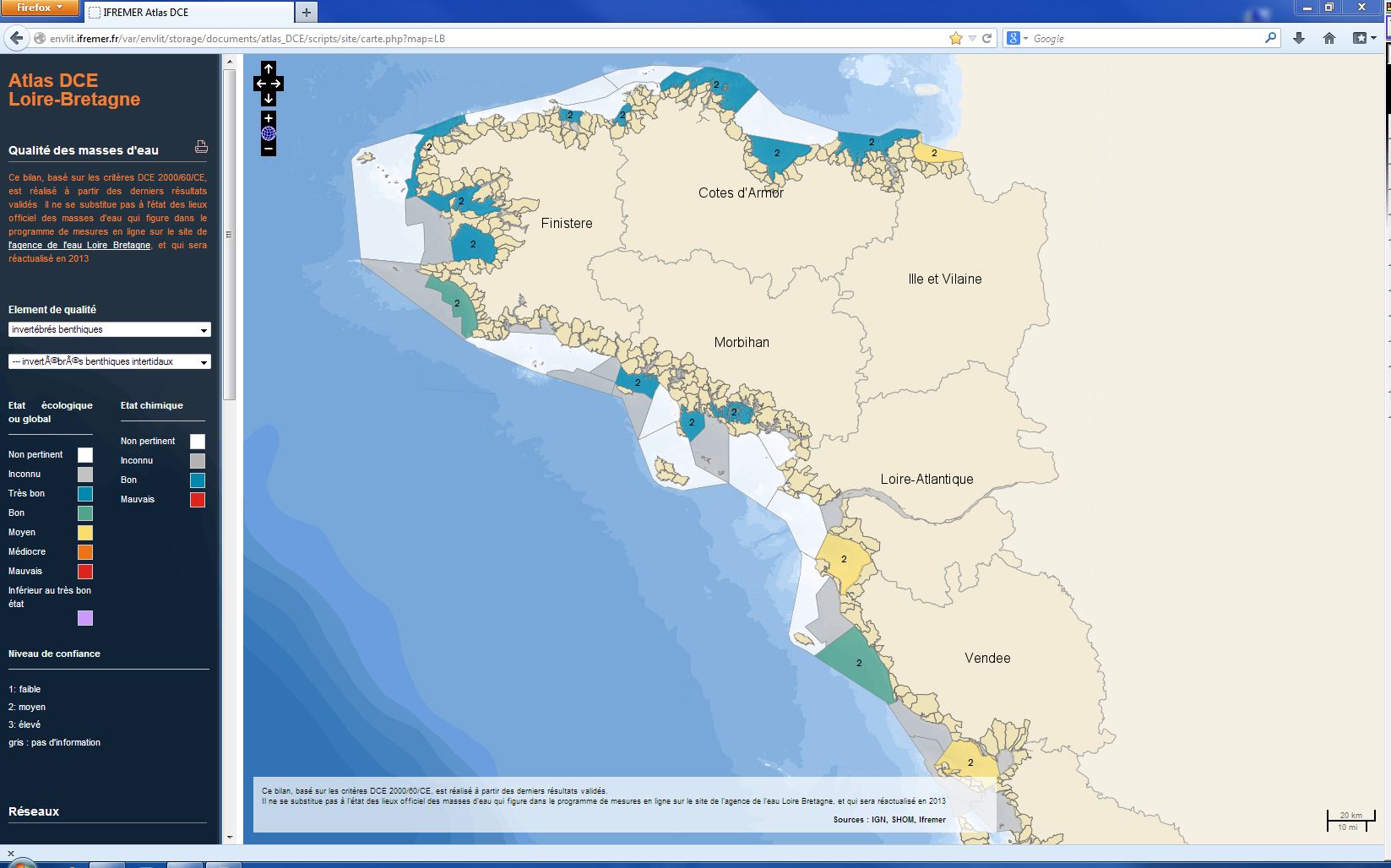
L’analyse porte sur le suivi des peuplements d'invertébrés benthiques des masses d'eaux côtières et de transition de la Manche ouest et du golfe de Gascogne et l'évaluation de leur qualité biologique. Les macroinvertébrés benthiques constituent en effet d'excellents intégrateurs et indicateurs de l'état général du milieu et peuvent permettre notamment, grâce à certains organismes sensibles, d'identifier et de quantifier les pressions d'origine anthropique qui s'exercent sur ces masses d'eau. Les paramètres de l'élément de qualité "invertébrés benthiques" permettant de définir l'état biologique sont : - le niveau de diversité et d'abondance des taxa ; - tous les taxa sensibles aux perturbations. Les peuplements de macroinvertébrés benthiques sont suivis dans la zone intertidale. L’évaluation la plus récente de l’état de ces peuplements est présentée dans l’atlas DCE Loire-Bretagne. Les états antérieurs sont accessibles dans des archives annuelles
-
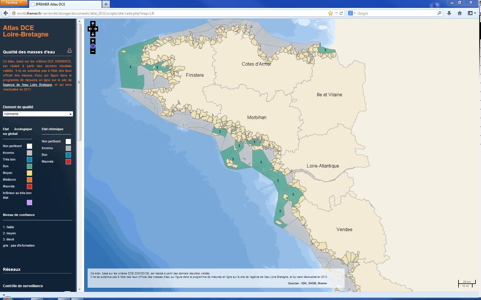
L’analyse porte sur le suivi des concentrations en nutriments des masses d'eaux côtières et de transition de la Manche ouest et du golfe de Gascogne. Le terme « nutriments » désigne l’ensemble des composés nécessaires à la nutrition du phytoplancton, dont les principaux sont le nitrate, le nitrite, l’ammonium, le phosphate et le silicate. Les nutriments ne sont pas directement toxiques pour le milieu marin, mais des flux excessifs déversés en zone côtière peuvent être considérés comme une pression à l’origine de nuisances indirectes pouvant conduire au phénomène d’eutrophisation. L’indicateur DCE nutriment est défini comme la combinaison des indices : ammonium, nitrate et nitrite. La métrique de l’indice est la concentration normalisée à 33 de salinité de l’ensemble des mesures effectuées, relativisée par rapport à un symptôme primaire d’eutrophisation : la chlorophylle-a. Les dosages de nutriments sont faits sur des échantillons prélevés mensuellement 4 à 12 fois par an. L’évaluation la plus récente de l’état de cet élément est présentée dans l’atlas DCE Loire-Bretagne. Les états antérieurs sont accessibles dans des archives annuelles.
-
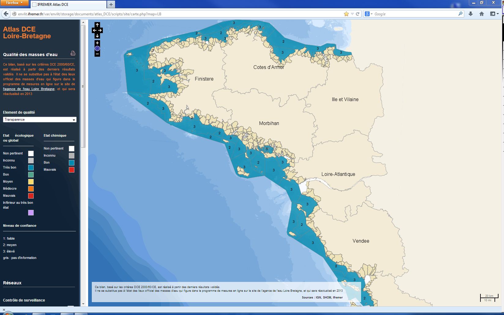
L’analyse porte sur les valeurs du paramètre turbidité (NTU) mesuré dans les eaux côtières et de transition de la Manche ouest et du golfe de Gascogne. Seule est considérée la période de plus forte production primaire (mars à octobre), à l'exclusion des épisodes turbides hivernaux provoqués par les conditions météorologiques (période de faible production primaire). L’indicateur de transparence est le percentile 90, qui correspond à la valeur telle que 90% des valeurs observées lui sont inférieures. Il est comparé à la valeur de référence pour le type de la masse d'eau. La transparence est un paramètre pour lequel les résultats n’ont pas entraîné jusqu'à présent de modification du classement DCE au cours des dernières années. C’est pourquoi, la mise à jour n'est faite pour chaque masse d'eau qu’une fois par plan de gestion de 6 ans, sauf si des observations nouvelles et marquantes venaient modifier l’évaluation.