 Catalogue PIGMA
Dissolved oxygen
Type of resources
Available actions
Topics
Keywords
Contact for the resource
Provided by
Years
Formats
Representation types
Update frequencies
status
Scale
-
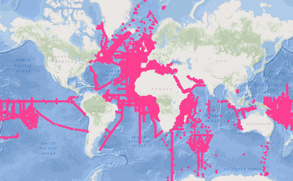
Measurements by drifting surface buoys. This system is a drifting mooring consisting of a surface buoy fastened to a floating anchor by a cable (trip line, buoy rope). It has to monitor as precisely as possible the water volume in which the floating anchor is immersed. The surface buoys are traced by Argos satellites.
-
This In Situ delayed mode product integrates the best available version of in situ oxygen, chlorophyll / fluorescence and nutrients data. The latest version of Copernicus delayed-mode BGC (bio-geo-chemical) product is also distributed from Copernicus Marine catalogue.
-
This product contains observations and gridded files from two up-to-date carbon and biogeochemistry community data products: Surface Ocean Carbon ATlas SOCATv2023 and GLobal Ocean Data Analysis Project GLODAPv2.2023. The SOCATv2023-OBS dataset contains >25 million observations of fugacity of CO2 of the surface global ocean from 1957 to early 2023. The quality control procedures are described in Bakker et al. (2016). These observations form the basis of the gridded products included in SOCATv2023-GRIDDED: monthly, yearly and decadal averages of fCO2 over a 1x1 degree grid over the global ocean, and a 0.25x0.25 degree, monthly average for the coastal ocean. GLODAPv2.2023-OBS contains >1 million observations from individual seawater samples of temperature, salinity, oxygen, nutrients, dissolved inorganic carbon, total alkalinity and pH from 1972 to 2021. These data were subjected to an extensive quality control and bias correction described in Olsen et al. (2020). GLODAPv2-GRIDDED contains global climatologies for temperature, salinity, oxygen, nitrate, phosphate, silicate, dissolved inorganic carbon, total alkalinity and pH over a 1x1 degree horizontal grid and 33 standard depths using the observations from the previous major iteration of GLODAP, GLODAPv2. SOCAT and GLODAP are based on community, largely volunteer efforts, and the data providers will appreciate that those who use the data cite the corresponding articles (see References below) in order to support future sustainability of the data products.
-
CTD data collected during the French oceanographic cruises or joint programs.
-
Bottle samples measurements collected during the French hydrological cruises or during joint experiments.
-
This REPHY dataset includes long-term time series on marine phytoplankton and physico-chemical measures, since 1987, along the whole French metropolitan coast. Some of these data are shared with those of the following regional networks: SRN (Hauts-de-France), RHLN (Normandy), ARCHYD (Arcachon), RSLHYD (Mediterranean lagoons). REPHY dataset from overseas departments (Martinique, Guadeloupe and French Guiana in West Atlantic waters; Reunion Island and Mayotte in Indian Ocean) will be available later. Phytoplankton data essentially cover microscopic taxonomic identifications and counts, but also pigments measures and flux cytometry measures in few regions. Physico-chemical measures include temperature, salinity, turbidity, dissolved oxygen, nutrients and chlorophylle a. The whole dataset is available, but is also divided into regions: North Sea + Channel + Atlantic, Mediterranean. For each of these two regional datasets, one includes only phytoplankton counts (PHYTO), the other (HYDRO) includes physico-chemical measures, pigments and flux cytometry measures.
-
The MAGEST observation network aims to continuously monitor the physico-chemical quality of the waters of the estuaries of Northern Aquitaine. In 2023, this regional network is composed of 12 stations.
-
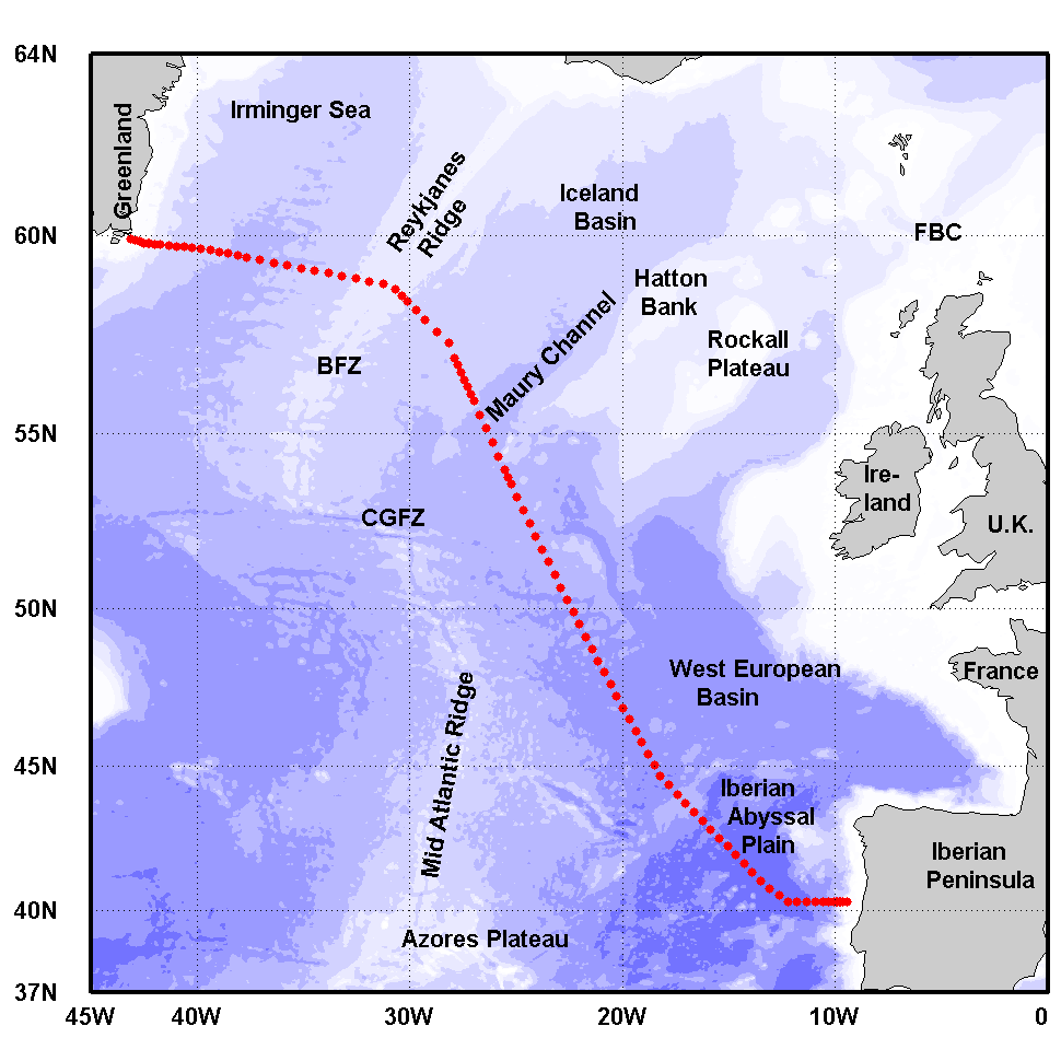
The Greenland-Portugal A25 OVIDE line is carried out biennially since 2002. The section is composed of 98 stations where hydrographic, biogeochemical and current measurements are carried out down to the bottom. OVIDE is a contribution to the international programs Go-Ship, IOCCP, and CLIVAR. This data set contains the final (adjusted) CTDO2 data.
-
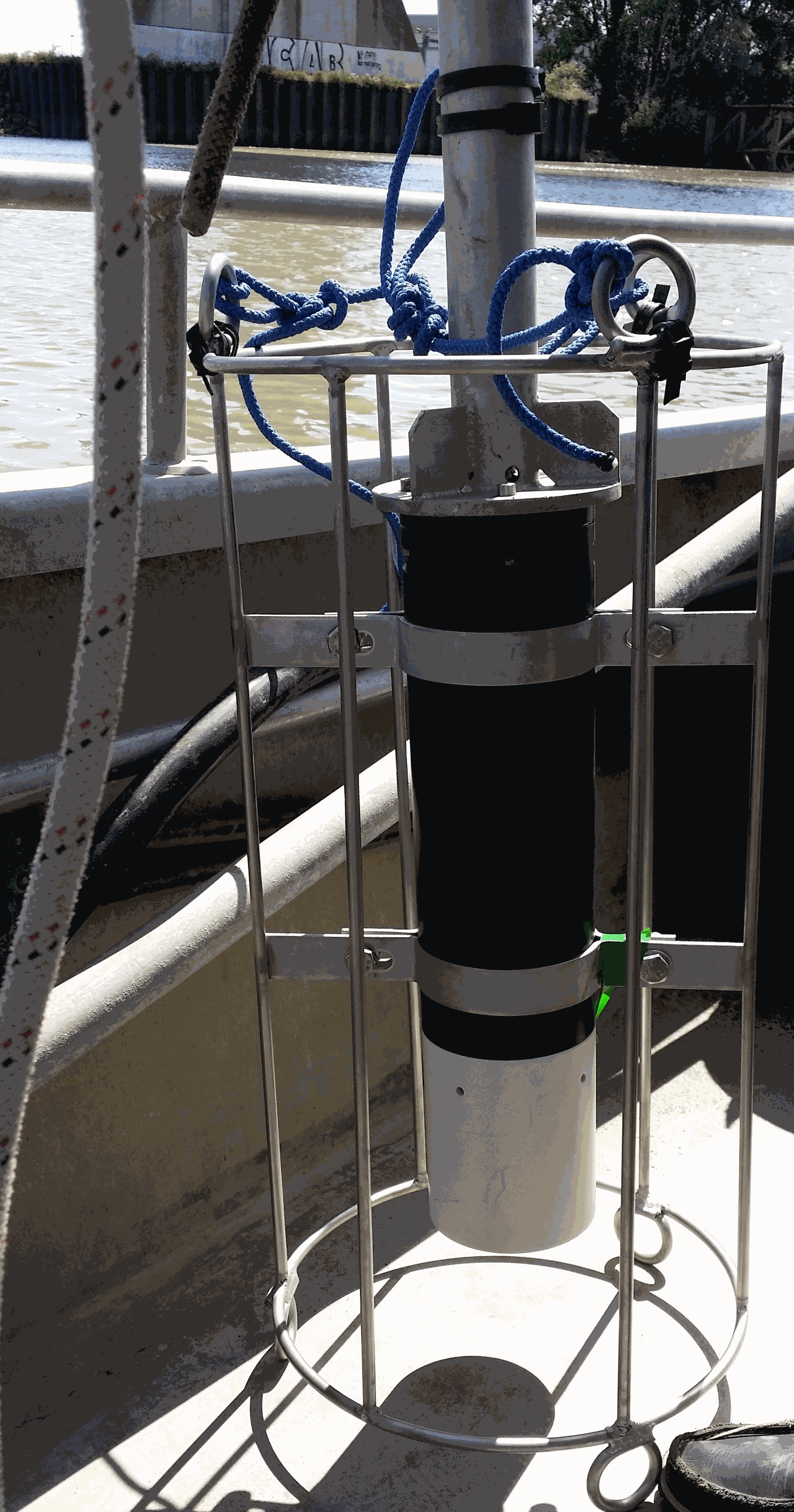
Key physico-chemical parameters (salinity, temperature, turbidity and dissolved oxygen) were measured in surface water during longitudinal transects in the Loire and Gironde estuaries in summers 2017 and 2018. This objective of this work was to determine the distribution of the dissolved oxygen and to detect potential severe desoxygenation. The transects were scheduled in order to begin the measurements at high tide from a site located upstream of an area where severe deoxygenation have been already been reported. Then, the transect was realised by sailing at low speed downstream with a multiparameter probe SAMBAT, maintained at 0.5 m below the surface, that collected a measurement every 2 minutes.
-
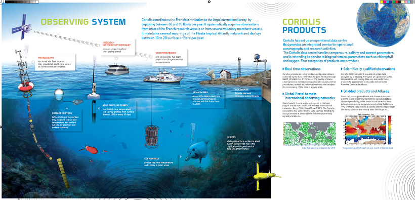
The CORIOLIS data center contributes to the “in situ observations” of operational oceanography, in addition to ocean surface measurements performed using equipment installed on satellites. This contribution is accomplished through the creation of permanent and lasting networks from ships or moored or drifting autonomous systems.