 Catalogue PIGMA
Gironde Estuary
Type of resources
Available actions
Topics
Keywords
Contact for the resource
Provided by
Years
Formats
-
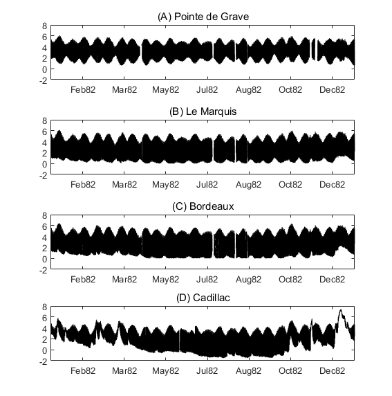
Times series of water level at four stations of the Gironde Estuary (Pointe de Grave, Le Marquis, Bordeaux and Cadillac) for the the years 1953, 1971, 1982, 1994, 2005 and 2014. The dataset includes all of the time seris used in the publication: To what extent multidecadal changes in morphology and fluvial discharge impact tide in a convergent (turbid) tidal river (2018), Journal of Geophysical Research: Oceans.
-
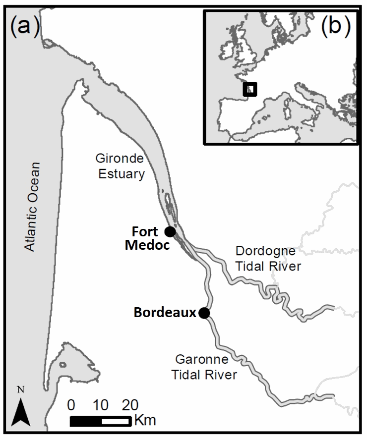
In the context of EMPHASE project (ANR-FRQ), two fields campaigns were carried out to determine the settling velocity and properties of suspended sediments during a semi-diurnal tidal cycle, as well as hydrodynamic conditions and water properties. The two sampling stations Bordeaux (Garonne Tidal River) and Fort Medoc (Gironde EStuary) were representative of two regions: a tidal river dominated by fresh water and an estuary affected by salty or brackish waters, inside the same land-sea continuum. Quasi in-situ measurements of settling velocity were carried out with a recently-patented instrument named System for the Characterisation of Aggregates and Flocs (SCAF).
-
In the framework of the ANR AMORAD project, the METEOR cruises (Grasso, 2017) aimed at deploying the ‘Gironde Estuary Mouth MEasurement Stations’ (GEMMES) to measure hydrodynamics and sediment dynamics at the mouth of the Gironde Estuary and on the West Gironde Mud Patch (SW France, Bay of Biscay). Measurements were carried out between November 2016 and December 2017: i) from a buoy station around 20-m water depth (GEMMES-20), collecting sub-surface data of temperature, salinity and turbidity; and ii) a benthic station around 40-m water depth (GEMMES-40), collecting data of current velocity and turbidity. Bottom and surface water samples were regularly collected to calibrate turbidity measurements to SPM concentrations.
-
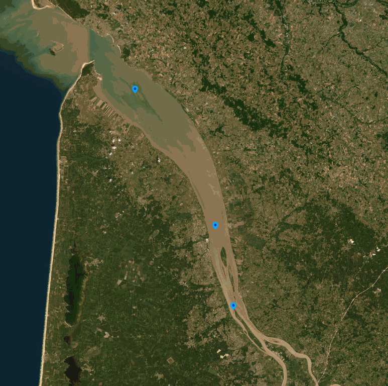
The SOMLIT-SOGIR time-series data characterize the hydrology of the Gironde Estuary ecosystem, located in the South-western France and flowing into the Bay of Biscay. Monthly-like measurements have been undertaken since 1997 by the OASU and EPOC teams (Univ. Bordeaux/CNRS). The SOMLIT-SOGIR time series is a part of the French monitoring network SOMLIT (https://www.somlit.fr/), labelled by the CNRS as a national Earth Science Observatory (Service National d’Observation : SNO). It aims to detect the long-term evolution of monitored ecosystems including both natural and anthropogenic forcings. Implemented at three sites (PK 30: 45.06833°N, 0.63833°W; PK 52: 45.24667°N, 0.725°W; PK 86: 45.5167°N, 0.95°W), the SOMLIT-SOGIR time series is among the oldest long-term coastal observation time series of the French Research Infrastructure dedicated to coastal ocean observations (RI ILICO, https://www.ir-ilico.fr). SOMLIT-SOGIR samples are collected at 1m below the water surface and 1m above the floor, at high and low tide, during slack water. Samples collected are analysed for 15 core parameters: water temperature and salinity, dissolved oxygen, pH, ammonia, nitrate, nitrite, phosphate, silicic acid, suspended particulate matter, particulate organic carbone, particulate nitrogen, chlorophyll a, delta15N and delta13C. CTD-PAR-profile is also performed at site PK86 during high tide. The SOMLIT network quality management system is in line with the ISO/IEC 17025:2017 standard: “General requirements for the competence of testing and calibration laboratories”. Further information on standard operating procedures for sample collection and data acquisition are available at: https://www.somlit.fr/parametres-et-protocoles. For more information on the quality flagging scheme: https://www.somlit.fr/codes-qualite/.
-
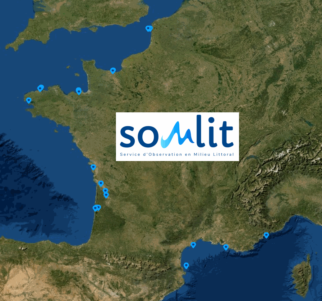
SOMLIT (Service d'Observation en Milieur Littoral) : a French Coastal Monitoring Network Coastal zones are where land, ocean and atmosphere interact. They are important for the exchange of matter and energy, and play a key role in (biogeo)chemical cycles at global scale. These environments are characterised by significant spatial and temporal variability of their physico-chemical and biological parameters due to local and seasonal meteorological drivers which are exacerbated by large-scale climate drivers (e.g. global warming, modification of the wind regime) and local-scale anthropogenic drivers (e.g. nutrient cycle changes linked to the use of fertilisers or the construction of large installations such as dams). These driving mechanisms are often interconnected. In the context of global warming (due to climate and human-induced changes), the identification and understanding of their impact on coastal marine and littoral ecosystems is essential. The scientific objective of SOMLIT is to 1) characterise the multi-decadal evolution of coastal marine and littoral ecosystems, and 2) determine the climatic and anthropogenic drivers. In order to meet this objective, a nationally coordinated multi-site monitoring system was set up in the mid-1990s. The observation strategy is the same for each of the 12 monitored ecosystems with fortnightly sampling and/or measurements, at high tide (for sites subject to tides): 1) in surface-water for a range of 15 parameters (temperature, salinity, dissolved oxygen, pH, nitrate, nitrite, ammonium, phosphate, silicate, suspended particulate matter, chlorophyll a, particulate organic carbon and nitrogen and stable isotopes of particulate organic carbon and nitrogen), 2) in surface-water for a range of 26 parameters of numbering and optical characteristics of pico- and nanoplankton), and 3) along the water column for temperature, salinity, fluorescence and PAR (vertical profiles of multi-parameter probes). SOMLIT’s activities are carried out under a quality assurance / quality control process based on the ISO 17025 standard. SOMLIT’s service provision objectives are to provide data and logistical support for research and other observation activities. SOMLIT has been officially accredited since 1996 as one of the CNRS (French National Centre for Scientific Research) National Observation Services (SNO). SOMLIT’s coordination is hosted by the Observatoire Aquitain des Sciences de l'Univers (University of Bordeaux / CNRS) and the service relies on strong partnerships with nine other institutions (University of Lille, University of the Littoral Opal Coast, University of Caen Normandy, Sorbonne University, University of Western Brittany, La Rochelle University, University of Montpellier, Aix Marseille University, National Museum of Natural History). SOMLIT is one of the nine networks that compose France’s Coastal Research Infrastructure (ILICO). SOMLIT has strong ties with ILICO’s other networks such as the SNOs MOOSE (Mediterranean Ocean Observing System on Environment), PHYTOBS (microphytoplankton monitoring) and COAST-HF (Coastal Ocean Observing System - High Frequency).