 Catalogue PIGMA
ISAS
Type of resources
Available actions
Topics
Keywords
Contact for the resource
Provided by
Years
Formats
Representation types
status
Scale
Resolution
-

This product contains weekly salinity field, based on SMOS and SMAP satellite data, and ISAS (In-Situ Analysis System).
-
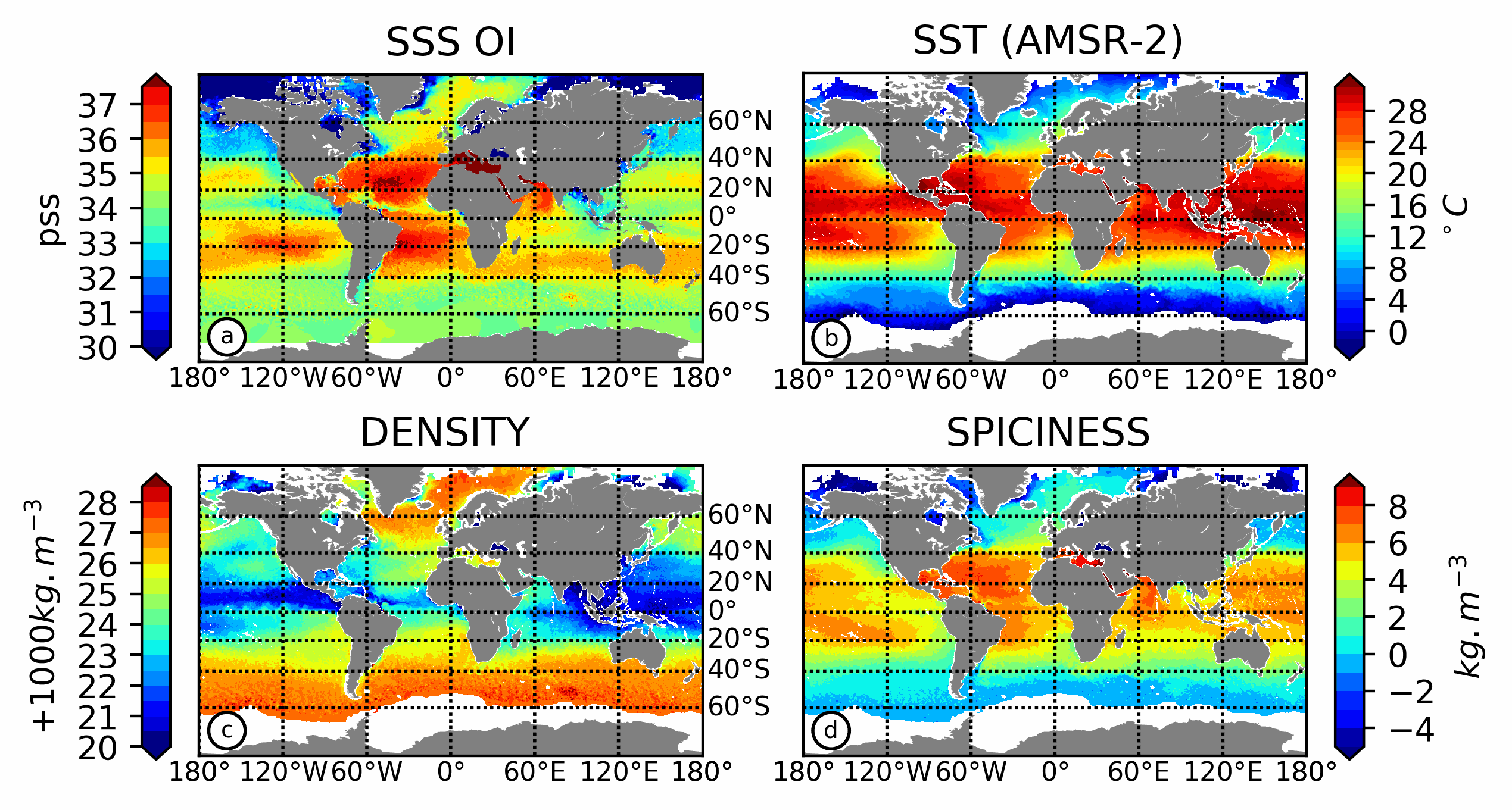
15 years of L-Band remote sensing Sea Surface Salinity (SSS) measurements have proven the capability of satellite SSS to resolve large scale to mesoscale SSS features in tropical to subtropical ocean. In mid to high latitude, L-Band measurements still suffer from large scale and time varying biases. Here, a simple method is proposed to mitigate the large scale and time varying biases. First, in order to estimate these biases, an Optimal Interpolation (OI) using a large correlation scale is used to map SMOS and SMAP L3 products and is compared to equivalent mapping of in situ observations. Then, a second mapping is performed on corrected SSS at scale of SMOS/SMAP resolution (~45 km). This procedure allows to correct and merge both products, and to increase signal to noise ratio of the absolute SSS estimates. Using thermodynamic equation of state (TEOS-10), the resulting L4 SSS product is combined with microwave satellite SST products to produce sea surface density and spiciness, useful to fully characterize the surface ocean water masses. The new L4 SSS products is validated against independent in situ measurements from low to high latitudes. The L4 products exhibits a significant improvement in mid-and high latitude in comparison to the existing SMOS and SMAP L3 products.
-
This product contains weekly salinity field, based on SMOS satellite data, and ISAS (In-Situ Analysis System). The L4OS SMOS-OI product contains global Level 4 analyses of the of the Sea Surface Salinity (SSS), Sea Surface Density (SSD) and Sea Surface Spiciness (SSSp), along with Sea Surface Absolute Salinity (SSA), Conservative Temperature (SCT), surface thermal expansion coefficient (alpha) and haline contraction coefficient (beta). The SSS product is obtained using an optimal interpolation (OI) algorithm, that combines ISAS in situ SSS OI analyses and Soil Moisture Ocean Salinity (SMOS) satellite image to reduce large scale and temporally varying bias. The SSS L4 product outcome is then combined with satellite SST products to compute thermodynamic sea water parameters using TEOS-10 (Kolodziejczyk et al., 2021). Products from reprocessing RE07 are available for the period 01/2011 - 05/2021. Products from operational (OPER) processing are available since 06/2021. Reprocessed products and operational products are derived using the same algorithm and configuration, hence ensuring the temporal continuity. The base products, for all the CATDS-PDC (Centre Aval de Traitement des Données SMOS - Production & Dissemination Center) processing chains, are the SMOS L1B products from ESA (European Space Agency). From these, brightness temperatures at various incidence angles are reconstructed. The Sea Surface Salinity (SSS) are retrieved from multi-angular brightness temperatures through a maximum likehood Bayesian approach in which measured Tb and Tb simulated using a forward direct model are compared (see Zine et al. 2008 for a general description of the retrieval method, and pro_con table for a summary of the similarities/differences with respect to ESA level 2 ocean salinity processing).