 Catalogue PIGMA
Marine geology
Type of resources
Available actions
Topics
Keywords
Contact for the resource
Provided by
Years
Formats
-
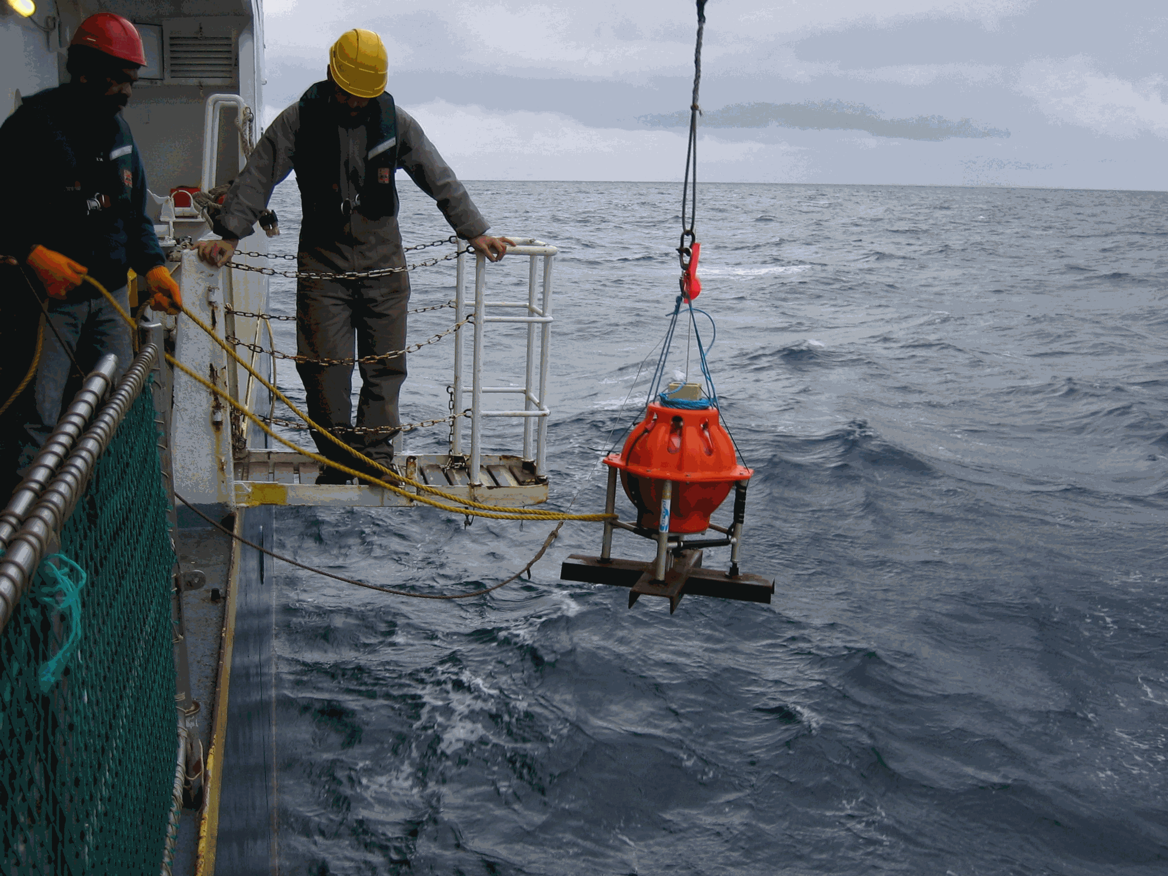
During the SARDINIA experiment, three coincident MCS reflection and wide-angle seismic profiles, sub-bottom high resolution (CHIRP) profiles, and bathymetry data were collected on the Gulf of Lion margin. The seismic reflection data were acquired using a 4.5 km, 360 trace digital streamer and a tuned airgun array of 8260 in3, towed at a depth of 18-28 m. A total of 57 ocean bottom seismometer/ hydrophones (OBS/OBH) from Ifremer, University of Brest, and Geomar Kiel were deployed in the Gulf of Lion, spaced every 7 Nm (~13 km). The airgun array consists of 16 airguns ranging from 100 in3 G-guns to 16 L Bolt airguns, with main frequencies centered around 10-15 Hz. The airguns were tuned to the first bubble to enhance low frequencies and ensure a good penetration. The shot interval was 60 s at an average speed of 5 knots, which translates to a trace spacing of about 140-150 m. The sample rate was 8 ms for the micrOBS, 5 ms for the Geomar’s OBS and 4 ms for the OldOBS. A total of 6160 shots (profile AB: 3032, profile CD: 1730, profile EF: 1398) were fired by the air gun array. Profile AB crosses the Gulf of Lion’s margin, parallel to the ECORS profile, from the continental shelf to Domain III. Twenty-five ocean bottom seismometers (OBS) were deployed on this profile, of 467 km in length. Twenty-two instruments were used in the wide-angle modelling, since three instruments (OBS 45, 49 and 52) did not properly record. The shots on this profile were additionally recorded by 9 land seismic stations (OSIRIS stations from the University of Brest and Geosciences Azur) that have extended the marine profile ~120 km onshore. Profiles CD and EF are 250 and 210 km long transects parallel to the margin. Profile CD was acquired using 19 OBS of which 18 yielded usable data. Profile EF was acquired using 15 OBS of which 12 yielded usable data. These two profiles cross the profile AB, respectivelyat OBS 26 and OBS 8.
-
210Pb, 226Ra and 137Cs were measured by non-destructive gamma spectrometry on marine sediment cores, collected during RIKEAU 2002 cruise on board r/v Thalia, on the shelf of the Bay of Biscay
-
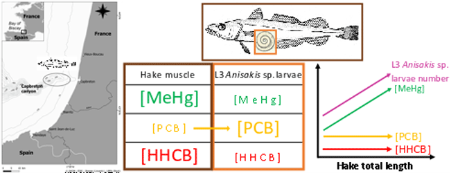
This dataset gathers isotopic ratios (carbon and nitrogen) and concentrations of both priority (mercury species and polychlorinated biphenyls congeners) and emerging (musks and sunscreens) micropollutants measured in a host-parasite couple (hake Merluccius merluccius muscle and in its parasite Anisakis sp) from the south of Bay of Biscay in 2018. In addition, the hake infection degree measured as the number of Anisakis sp. larvae was added for each hake collected.
-

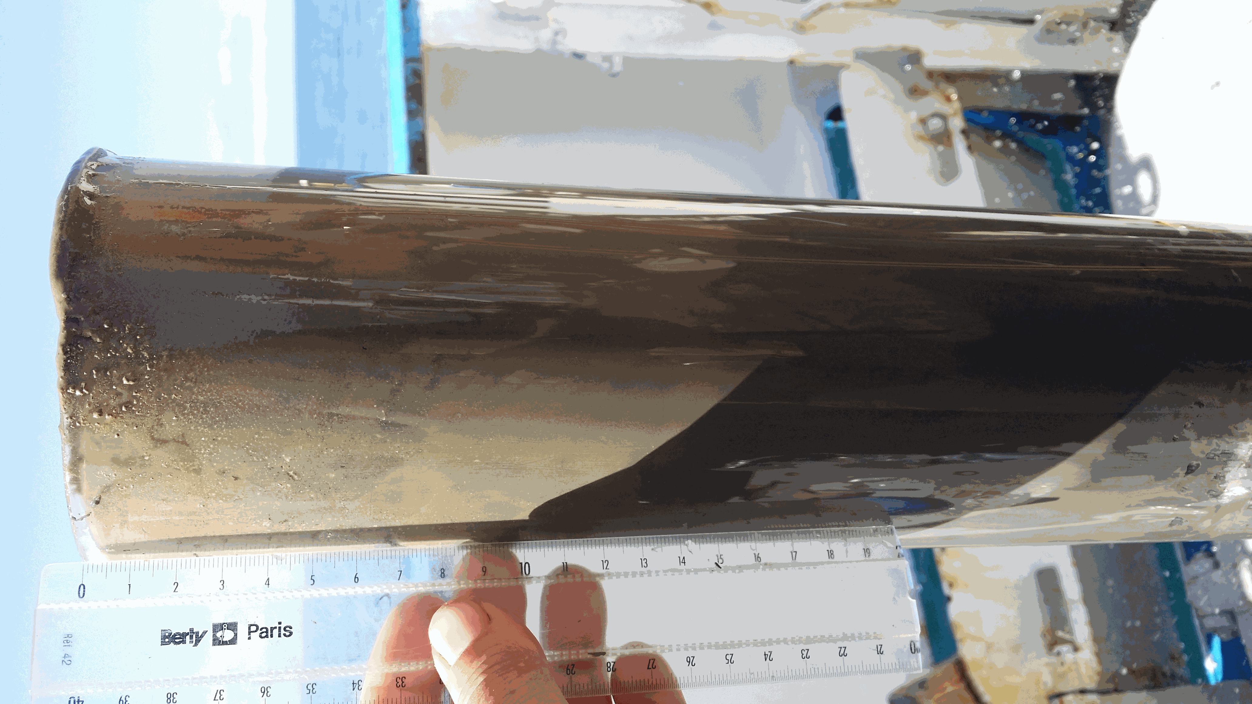
This set of data documents the radiocarbon dates (n=19) obtained thanks to the accelerator mass spectrometry method (AMS) at the LMC14/ARTEMIS French national facility on the cores (Multicorer, Kullenberg) retrieved from the West-Gironde mud patch (WGMP) during the JERICObent-7 cruise (10-15 July 2019; NR Côtes de la Manche, https://doi.org/10.17600/18001022). The WGMP registers very high sedimentation rates since the last 600 years (≥ 0.3 cm/yr) and is thus of great interest for palaeoceanographic investigations. At present, this depocenter marks the mid-shelf of the temperate Bay of Biscay off major French rivers from the Aquitaine basin. The fine mud deposits of the WGMP are of 3 to 4 meters thick and lie on palimpsest levels rich in gravels and shells. They cover a V-shaped structure, oriented SW-NE, which is attributed to the incision(s) of a paleovalley in the Cenozoic substrate, mainly linked to the paleo-Gironde routing changes during past glacials/interglacials, and its potential past convergences with the paleo-rivers of the Antioche perthuis (Seudre, Charente paleovalleys?) at that times. Detailed information on each sample is presented with the 14C results obtained by the Artemis AMS facility at LMC14 laboratory (Dumoulin et al. 2017- https://doi.org/10.1017/RDC.2016.116, Beck et al. 2024- https://doi.org/10.1017/RDC.2023.23). Raw ages are indicated together with calibration calculations using the last two versions of the Calib software (http://calib.org/, Calib 7 and 8) to show the dispersion of ages linked to the updating of calibration curves (Marine13, Intcal13, Marine20, Intcal 20). The calibrated ages finally retained for publications (used in the related Seanoe document - https://doi.org/10.17882/104237 - and published in Eynaud et al., 2025 for the ST3c core, https://doi.org/10.1016/j.gloplacha.2025.105039) are those obtained with the last Calib 8.1 version. Raw 14C ages were calibrated and converted to calendar ages using the IntCal20 calibration curve with a reservoir age correction of 400 years deduced from Radionuclide analyses (137Cs and 210Pb) at the top of the studied cores (see Schmidt, 2025, https://www.seanoe.org/data/00968/107979/).
-

The Mediterranean Sea is a natural laboratory to address questions about the formation and evolution of continental margins and the relationship between surface and deep processes. Different regional to local events have influenced the Neogene stratigraphic evolution of the Valencia and Menorca basins. The evaporites deposited during the Messinian Salinity Crisis (MSC) strongly impact its sedimentary and geomorphological evolution. Here we present a compilation of the main regional seismic stratigraphic markers from the continental platform to the deep sea. We provide in xyz format (z in second twt) the original picking files, (not interpolated) and interpolated grid of: i) the top of the Mesozoic formation, the base of the Neogene formations including the early Miocene volcanic features, ii) the top Burdigalian, Langhian, and Serravallian seismic horizons, iii) the seismic horizons related to the Messinian Salinity Crisis, iv) the Pliocene and Pleistocene seismic horizons v) the depth of the Seafloor. The available reflection seismic dataset results from the compilation and processing of vintage seismic profiles of previous works and from the Instituto Geologico y Minero de Espana (IGME). This compilation is currently the first available in literature and provides a useful contribution to the scientific community working on sedimentary, tectonics and geodynamics within the Western Mediterranean basins.
-
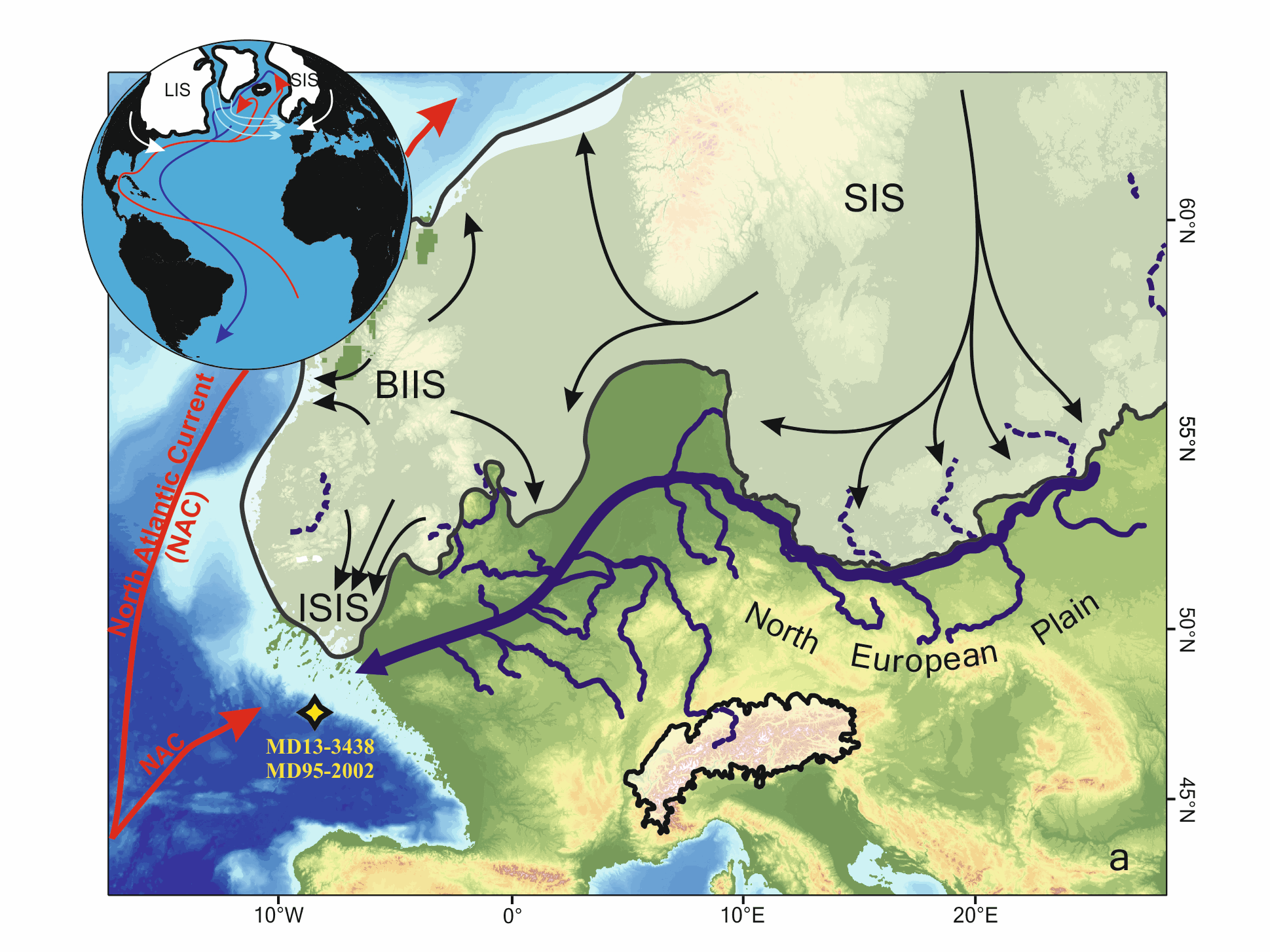
Marine microfossils (dinoflagellate cysts and planktonic foraminifera) and geochemical (XRF-Ti/Ca)-based climatic records from a core located off the Fleuve Manche (FM) paleo-mouth (MD13-3438) have revealed that sustained warm summer sea surface temperatures (SSTs) during sub-millennial climate changes within HS1 (~18–14.7 ka) may have played a key role in the FM regime related to the European Ice Sheet (EIS) melting rate. In this study, we have analyzed the MD13-3438 pollen content over the HS1 at a mean resolution of ~50 years to test whether vegetation-based air temperatures were coupled to SSTs face to this rapid climate variability. First, our results highlight two major phases of pollen sources at site MD13-3438, preventing the pollen record to be interpreted as a continuous record of the evolution of vegetation and climate occupying a single watershed across HS1. The first phase, i.e. the HS1-a interval (~18–16.8 ka), is marked by strong occurrences of boreal pollen taxa (especially Picea-Abies). Considering their spatial distribution and the coalescence of the British and Scandinavian ice sheets into the North Sea during the Last Glacial Maximum, these taxa probably originated from the North European Plain, i.e., eastern FM tributaries (east of the Rhine River), where cool-humid conditions generally prevailed. Then, the second phase, i.e. the HS1-b interval (~16.8–14.7 ka BP), is characterized by a deceleration of the EIS retreat and the drop of boreal pollen values at site MD13-3438 further signing a less influence of the upstream FM drainage system and thus a better characterization of pollen sources related with western FM tributaries. Superimposed to these two HS1 main phases, pollen fluctuations are concomitant with sub-millennial variability in the EIS deglaciation intensity. During the early HS1 (HS1-a), we discussed two short-term increases in the ratio between deciduous trees (Quercus-Corylus-Alnus) and herbaceous plants (Plantago-Amaranthaceae-Artemisia). These events were coeval with phases of increasing FM meltwater runoff and SST seasonality (i.e., dinocyst-based summer SST amplification). We associated these events with lower contribution of the upstream FM catchment as well as, possibly, atmospheric warming and regional sea-level positive oscillations. The HS1-b is composed of three main phases that appear more influenced by the downstream FM drainage system. HS1-b1 (16.8–16.3 ka BP) corresponds to the driest and coldest conditions west of the Rhine River. HS1-b2 (16.3–15.6 ka BP) is coeval with large arrivals of iceberg from the Hudson strait in the Bay of Biscay and thus likely to a major sea-level positive oscillation associated with a phase of FM valley reworking. HS1-b3 (15.6–14.7 ka BP) corresponds to persistent arid conditions that preceded the subsequent more humid conditions recorded from 14.7 ka BP at the start of the Bölling-Alleröd.
-
The West Gironde Mud Patch (WGMP) is a 420-km2 mud belt in the Bay of Biscay, located 25 km off the mouth of the Gironde estuary. This clay-silt feature of 4 m in thickness extends between 30 and 75m water depth, surrounded by the sands and gravels that cover the North Aquitaine continental shelf. Interface cores were collected during JERICOBent-1 cruise (October 2016; Deflandre (2016) doi.org/10.17600/16010400) along two cross-shelf transects for a total of 9 sites. Each sediment core was carefully extruded every 0.5 cm from the top core to 4 cm and every 1 cm below until the core bottom. The sediment layers were used to determine dry bulk density, grain size and selected radioisotope activities (210Pb, 226Ra, 137Cs, 228Th, K).
-
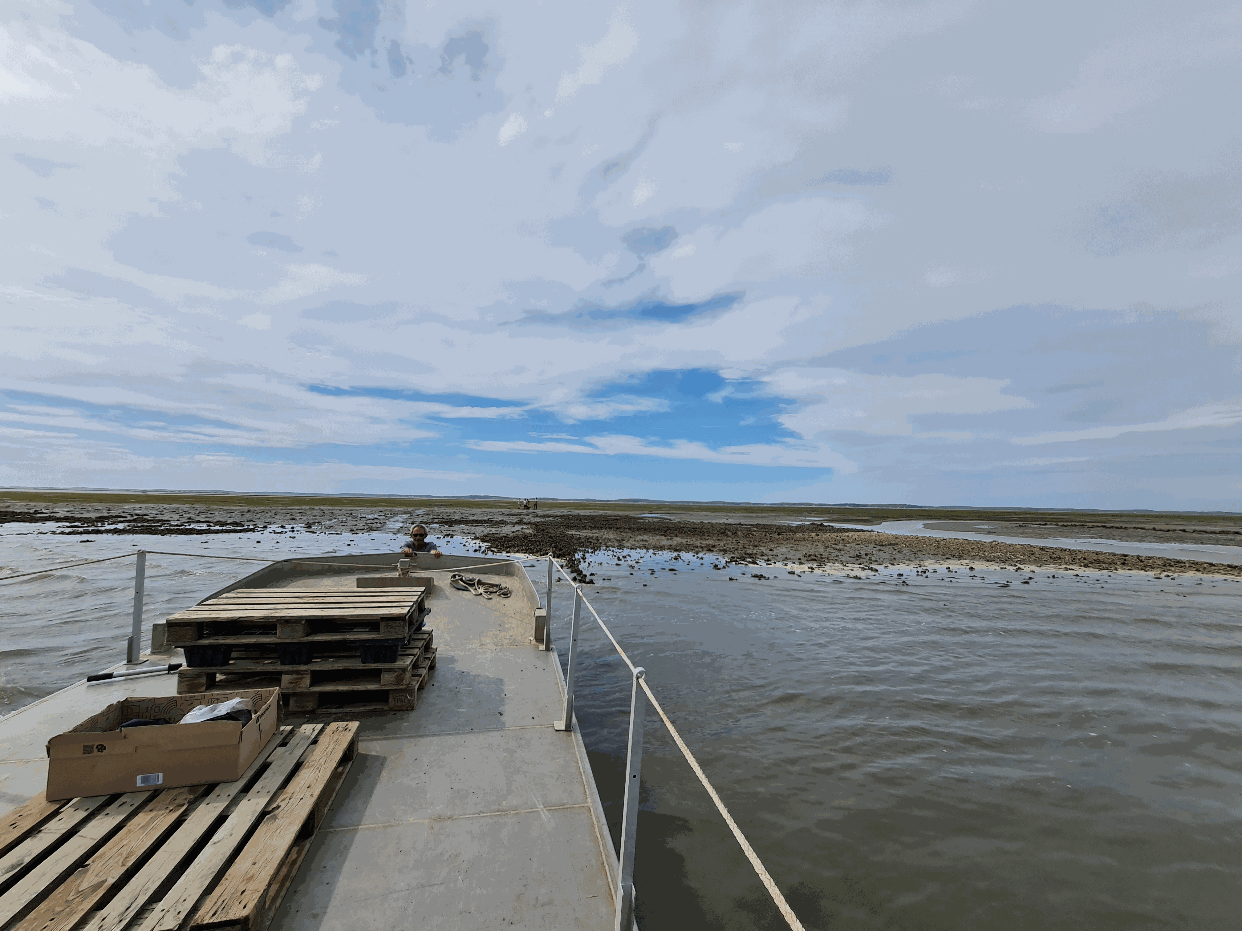
The Arcachon Bay is a unique and ecologically important meso-tidal lagoon on the Atlantic coast of south-west France. The Arcachon Bay has the largest area of dwarf seagrass (Z. noltei) in Europe, the extent of which was stable in their extent between the 1950s and 1990s, but a decline in seagrass was observed in mid-2000. The decline of Zostera (seagrass) may have a significant impact on sedimentation in this coastal ecosystem rich in marine life. Interface cores were collected in September 2022 to determine sediment and mass accumulation rates (SAR, MAR) in the Arcachon Bay. Ten study areas were selected, distributed over most of the areas where seagrass meadows are actually observed. Two sites were visited each time, one with the presence of Zostera noltei in good condition (Healthy) and the other where the sediment was bare (Bare). Maximum water heights during spring tides range from 3.44 m for the deepest site (Garrèche) to 2.09 m for the shallowest site (Fontaines). A total of 20 sediment cores were sampled and carefully extruded every 1 cm from the top to the bottom of the core. The sediment layers were used to determine dry bulk density and selected radioisotope activities: DBD, 210Pb, 226Ra, 137Cs, 228Th and 40K expressed as %K).
-
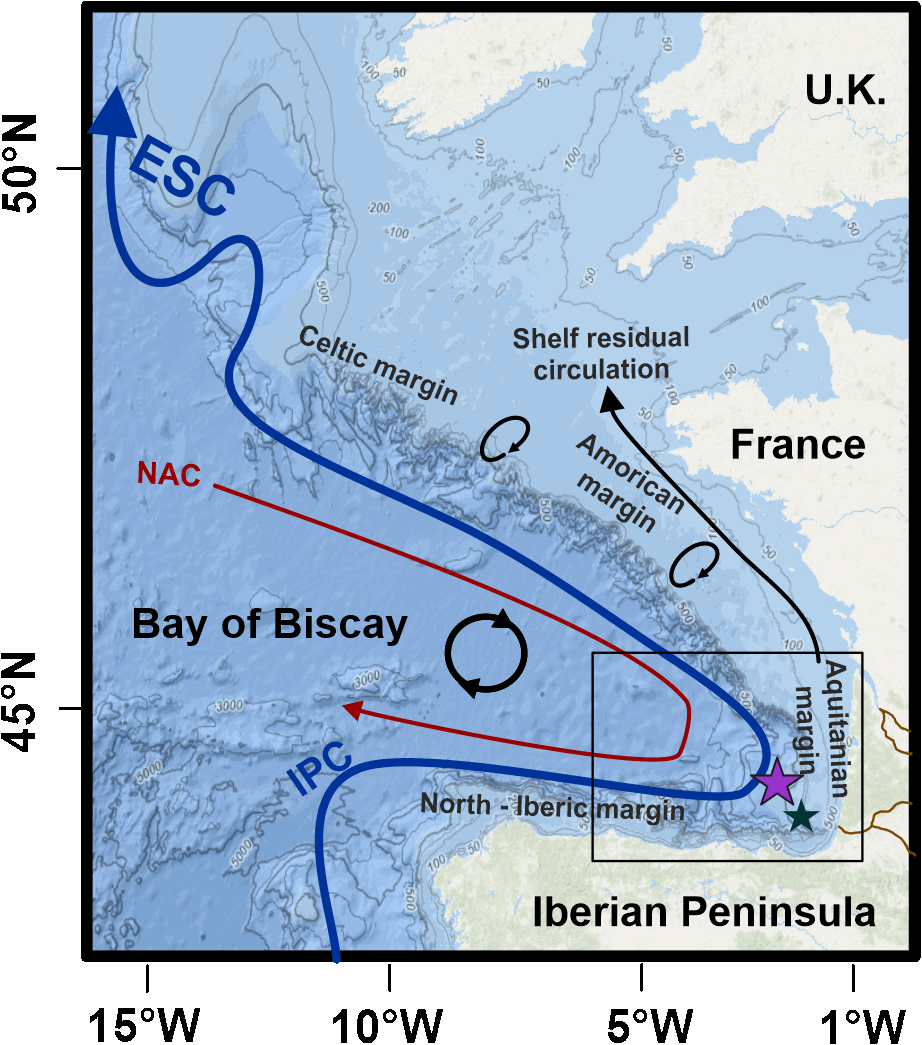
In the mid-latitudes of the northeast Atlantic, the study of the upper branch of the AMOC is poorly documented. This study provides a complete record of the glacial, deglacial and Holocene dynamics of the easternmost portion of the upper branch of the AMOC, namely the European Slope Current and its glacial equivalent know as the Glacial Eastern Boundary Current (GEBC). To do so, we use core SU81-44 (~1000 m water depth) from the of southern Bay of Biscay (BoB) upper slope, .The aim of this study is to reconstruct paleoenvironmental and hydrodynamic changes using a multiproxy approach (i.e. benthic foraminiferal assemblage, grain size proxies, oxygen and carbon stable isotopes, and foraminiferal εNd). During the glacial period and the onset of the deglaciation, our results show that the grain size proxies together with the relative densities of the high-energy indicator species Trifarina angulosa and the low oxygen tolerant Globobulimina spp. showed significant fluctuations. These were concomitant with the main climate changes recognized over this period and with the glacial slope paleoflow reconstruction from the northern BoB. This highlights a strong climatic/oceanographic forcing on the sedimentary characteristics of the region and a prominent forcing by changes in near-bottom flow speed. Our data also provide a new constraint on the strength of the slope current in the region during the late deglaciation and Holocene periods. We observe a reinvigoration of the upper branch of the AMOC during the Bølling-Allerød warming, preceding the abrupt resumption of the deeper branch of the AMOC in the western North Atlantic. This seems to confirm the crucial role of the European Slope Current in deep water formation, as it is the case today. Finally, our data show a progressive weakening of the ESC during the Holocene and we hypothesize a link with the long-term dynamics of the subpolar gyre.
-
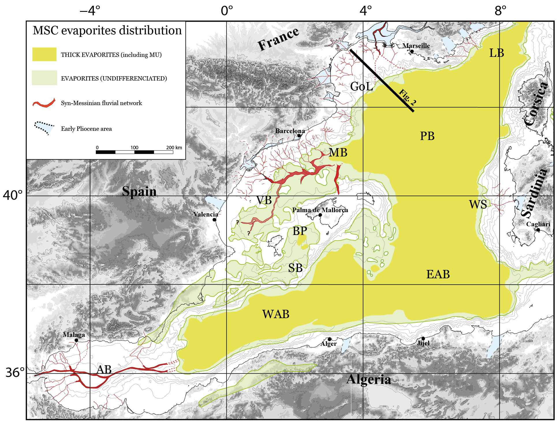
The Western Mediterranean Sea is a natural laboratory to address questions about the formation and evolution of continental margins and the relationship between surface and deep processes. The evaporites deposited during the late Miocene’s Messinian Salinity Crisis (MSC) strongly impact its sedimentological and geomorphological evolution. Hereafter, we present a compilation of some of the main regional seismic stratigraphic markers throughout the Western Mediterranean Sea. We provide in xyz format (z in second twt) the original, not interpolated, points interpretation of the following horizons: i) Acoustic basement, ii) Base and Top of the MSC salt, also known as Mobile Unit (MU), iii) base Pliocene and iv) Seafloor. The available reflection seismic dataset, coming from a collaboration between French, Spanish, Algerian and Italian research institutes, covers most of the Western Mediterranean sub-basins with the exception of the Ligurian Basin. This compilation is currently the most comprehensive and updated available in literature and provides a useful contribution to the scientific community working in sedimentary, tectonics and geodynamics studies in the Western Mediterranean Sea.