 Catalogue PIGMA
North Mid-Atlantic Ridge
Type of resources
Available actions
Topics
Keywords
Contact for the resource
Provided by
Years
Formats
Representation types
Update frequencies
status
Scale
Resolution
-
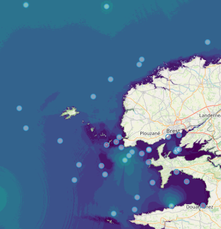
Quonops Online Services provide noise monitoring and prediction tools. In a similar manner to weather forecasting systems, Quonops© produces an estimate of the spatio-temporal distribution of noise levels generated by human activities at sea, aggregating multiple sources, and assessing short-, mid- and long-term source contributions to the global noise field. The outputs from Quonops© are tailored to the requirements of existing and emerging national and international regulations regarding: - Underwater noise. - The conservation of habitats and marine ecosystems. - The protection of marine species. Such tools aim to support management decisions by assessing, quantifying and prioritizing direct and indirect anthropogenic pressures on marine life, according to regulations on underwater noise, especially the descriptor 11 of the European Marine Strategy Framework Directive.
-

Built and developed by researchers, to ensure that everyone can join in Open Science. The OpenAIRE project, in the vanguard of the open access and open data movements in Europe was commissioned by the EC to support their nascent Open Data policy by providing a catch-all repository for EC funded research. CERN, an OpenAIRE partner and pioneer in open source, open access and open data, provided this capability and Zenodo was launched in May 2013. In support of its research programme CERN has developed tools for Big Data management and extended Digital Library capabilities for Open Data. Through Zenodo these Big Science tools could be effectively shared with the long-tail of research. Zenodo helps researchers receive credit by making the research results citable and through OpenAIRE integrates them into existing reporting lines to funding agencies like the European Commission. Citation information is also passed to DataCite and onto the scholarly aggregators.
-

Portal to view and download observations of Vulnerable Marine Ecosystem (VME) indicators and habitats in the North Atlantic. A central portal for data on the distribution and abundance of Vulnerable Marine Ecosystems (VMEs), (and organisms considered to be indicators of VMEs) across the North Atlantic has been set up by the Joint ICES/NAFO Working Group on Deep-water Ecology (WGDEC). Criteria used to select habitats and indicators for inclusion in the database were those described in the FAO International Guidelines for the Management of Deep-sea Fisheries in the High Seas (FAO, 2009). The database is comprised of: - 'VME habitats' that are records for which there is unequivocal evidence for a VME, e.g. ROV observations of a coral reef - 'VME indicators' which are records that suggest the presence of a VME with varying degrees of uncertainty. For VME indicators a weighting system of vulnerability and uncertainty is provided as part of the database to aid interpretation. The VME database may be used for many purposes. ICES uses it when providing scientifically-robust advice on the distribution of VMEs and recommending possible management solutions such as bottom fishing closures within North East Atlantic Fisheries Commission (NEAFC) waters to protect VMEs.
-
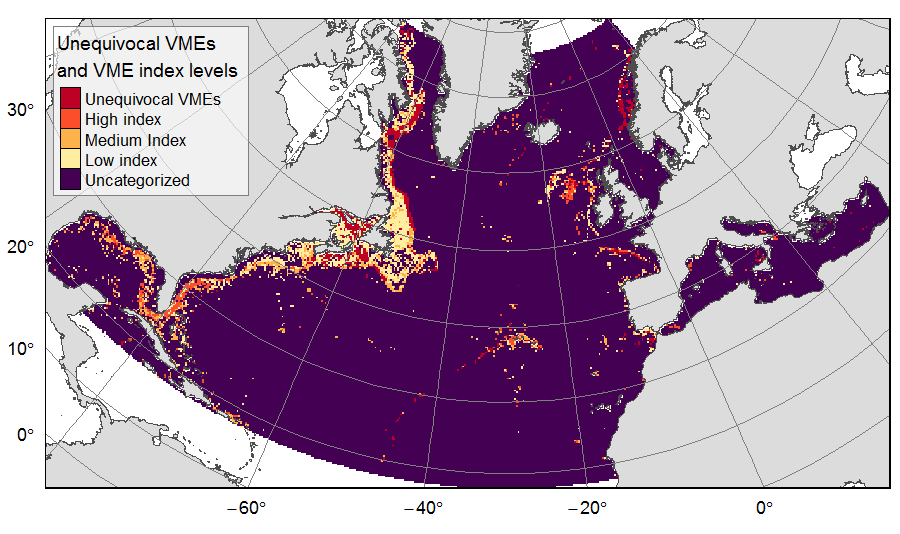
Distribution of unequivocal Vulnerable Marine Ecosystems (VMEs) and VME likelihood based on indicator taxa records, on the North Atlantic (18°N to 76°N and 36°E to 98°W). Several datasets, originating from public databases, literature review and data call to ATLAS partners, were gathered to compute the presence of unequivocal VME habitats in 25km * 25 km cells for the ATLAS work package 3. One layer displays the unequivocal VMEs (value=4) and the assigned high (value=3), medium (value=2) or low (value=1) likelihood of gridsquares to host VMEs, indexed on indicator taxa records from public databases with the method detailed in Morato et al (2018). The second displays the confidence associated to the VME likelihood score, indexed on data quality as detailed in Morato et al (2018) (values for unequivocal VMEs thus 100% confidence=4; high confidence=3; medium confidence=2; low confidence=1). This dataset was built to feed a basin-wide spatial conservation planning exercise, targeting the deep sea of the North Atlantic. The goal of this approach was to identify conservation priority areas for Vulnerable Marine Ecosystems (VMEs) and deep fish species, based on the distribution of species and habitats, human activities and current spatial management.
-

MISSION ATLANTIC assesses the whole Atlantic, and ecosystem components at risk from natural hazards and the consequences of human activities, including individual regional Case Studies, and their interconnectivity. To do this, Mission Atlantic develops IEAs for seven regional Case Studies, in sub-Arctic and Tropical regions of the Atlantic Ocean, ranging from shelf seas to the mid-Atlantic Ridge: 1) Norwegian Sea 2) Celtic Sea 3) Canary Current 4) North Mid Atlantic Ridge 5) South Mid Atlantic Ridge 6) Benguela Current 7) South Brazilian Shelf
-
A marine end-to-end ecosystem model and R package. The aim is to represent the entire interconnected marine ecosystem (from physics and chemistry, to whales and fisheries in continental shelf regions) by exploring 'what if' experiments and explore uncertainty. View the application, the website or the latest publication.
-
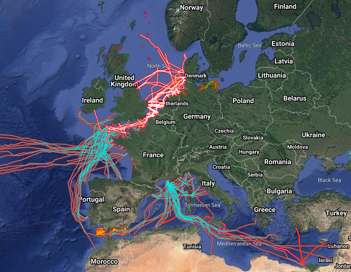
The datasets on subsea telecommunication and power cables (actual routes) in the EU was created in 2014 by Cogea for the European Marine Observation and Data Network (EMODnet). It is the result of the aggregation and harmonization of datasets provided by several sources. It is updated every year and is available for viewing and download on EMODnet Human Activities web portal (www.emodnet-humanactivities.eu). The datasets contain lines representing actual cable routes locations. Compared with the previous version, this version includes an update of the French telecommunication cables, the telecommunication cables that originate from or pass through Spanish (Andalucia) and Dutch waters, and the electric cables that originate from or pass through French, Dutch and Norwegian waters.
-
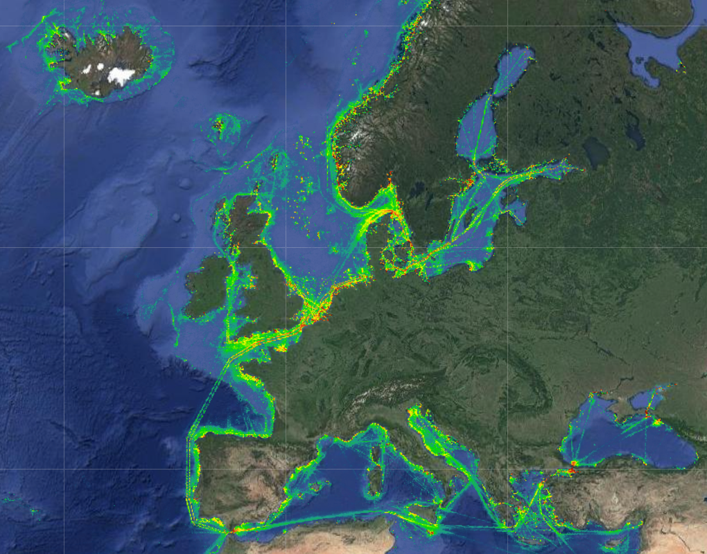
The Vessel Density maps in the EU were created in 2019 by Cogea for the European Marine Observation and Data Network (EMODnet). The dataset is updated every year and is available for viewing and download on EMODnet Human Activities web portal (www.emodnet-humanactivities.eu). The maps are based on AIS data yearly purchased from Collecte Localisation Satellites (CLS) and ORBCOMM. The maps, GeoTIFF format, show shipping density in 1x1km cells of a grid covering all EU waters and some neighbouring areas. Density is expressed as hours per square kilometre per month. The following ship types are available:0 Other, 1 Fishing, 2 Service, 3 Dredging or underwater ops, 4 Sailing, 5 Pleasure Craft, 6 High speed craft, 7 Tug and towing, 8 Passenger, 9 Cargo, 10 Tanker, 11 Military and Law Enforcement, 12 Unknown and All ship types. Data are available by month of year. Yearly averages are also available.
-

Script for performing the Mission Atlantic RISK Analysis. It has been modified from the ODEMM ('Options for Delivering Ecosystem-Based Marine Management') - approach. For details see https://doi.org/10.3389/fmars.2022.1037878
-

The ecorisk package will be published under this repository soon. The ecorisk R package is designed to perform and analyse (ecosystem) risk assessments.