 Catalogue PIGMA
Pelagos
Type of resources
Available actions
Topics
Keywords
Provided by
Years
Formats
Representation types
Update frequencies
status
Scale
Resolution
-

The PHYTOBS-Network dataset includes long-term time series on marine microphytoplankton, since 1987, along the whole French metropolitan coast. Microphytoplankton data cover microscopic taxonomic identifications and counts. The whole dataset is available, it includes 25 sampling locations. PHYTOBS-Network studies microphytoplankton diversity in the hydrological context along French coasts under gradients of anthropogenic pressures. PHYTOBS-Network allows to analyse the responses of phytoplankton communities to environmental changes, to assess the quality of the coastal environment through indicators, to define ecological niches, to detect variations in bloom phenology, and to support any scientific question by providing data. The PHYTOBS-Network provides the scientific community and stakeholders with validated and qualified data, in order to improve knowledge regarding biomass, abundance and composition of marine microphytoplankton in coastal and lagoon waters in their hydrological context. PHYTOBS-Network originates of two networks. The historical REPHY (French Observation and Monitoring program for Phytoplankton and Hydrology in coastal waters) supported by Ifremer since 1984 and the SOMLIT (Service d'observation en milieu littoral) supported by INSU-CNRS since 1995. The monitoring has started in 1987 on some sites and later in others. Hydrological data are provided by REPHY or SOMLIT network as a function of site locations.
-
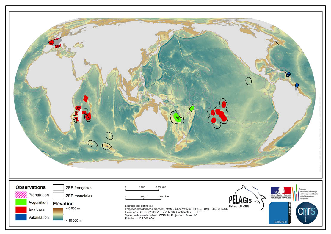
La donnée associée met en évidence l'emprise spatiale de l'ensemble du jeu de données de type "Observations visuelles sur plateforme aérienne" de l'Observatoire PELAGIS. Les emprises représentent les différentes régions d'études sur lesquelles l'Observatoire PELAGIS a effectué des campagnes d'observations visuelles sur plateformes aériennes. Pour chaque région d'étude est associée au moins une campagne, avec des observateurs liés à cette campagne, et les secteurs géographiques d'étude liés à cette campagne. Pour chaque secteur sont associées des strates bathymétriques et des transects liés à chacune de ces strates à quelques exceptions près pour la région Océan Indien. Description des champs et valeurs de la tables attributaires : ( - nom champ, signification : valeur, description des valeurs) - region, région d'étude propre à ll'Observatoire PELAGIS : OI/FRM/AGFR/SOP/SP, region_lbl - programme, Programme associé dans lequel s'inscrit une campagne : REMMOA/PACOMM, REcensement de la Mégafaune Marine par Observation Aérienne/Programme d'Acquisition sur les Oiseaux et Mammifères Marins - idCampagne, nom court de la campagne d'acquisition : OI/SAMM/ANT/SOP/PF/GUY, Campagne Océan Indien/Suivi Aérien de la Mégafaune Marine/Sud Ouest Pacifique/Polynésie Française/Guyane française - avancement, état d'avancement des campagnes, depuis l'acquisition à la valorisation scientifique : Préparation/Acquisition/Analyses/Valorisation, campagne en préparation/en cours d'acquisition/en cours d'analyses/données valorisées dans le cadre d'une publication scientifique.
-
Le SNO PHYTOBS-Network a pour objectif de constituer un réseau national de dispositifs d'observation du microphytoplancton dont les principales caractéristiques sont des fréquences d'échantillonnages élevées et de nombreux paramètres mesurés tant biologiques (dont l'estimation du phytoplancton total) que physico-chimiques. Le réseau PHYTOBS-Network associe les moyens et les compétences de l'IFREMER, du CNRS et des universités. Le SNO PHYTOBS fait partie de l'un des 8 réseaux élémentaires de l'IR-ILICO.
-
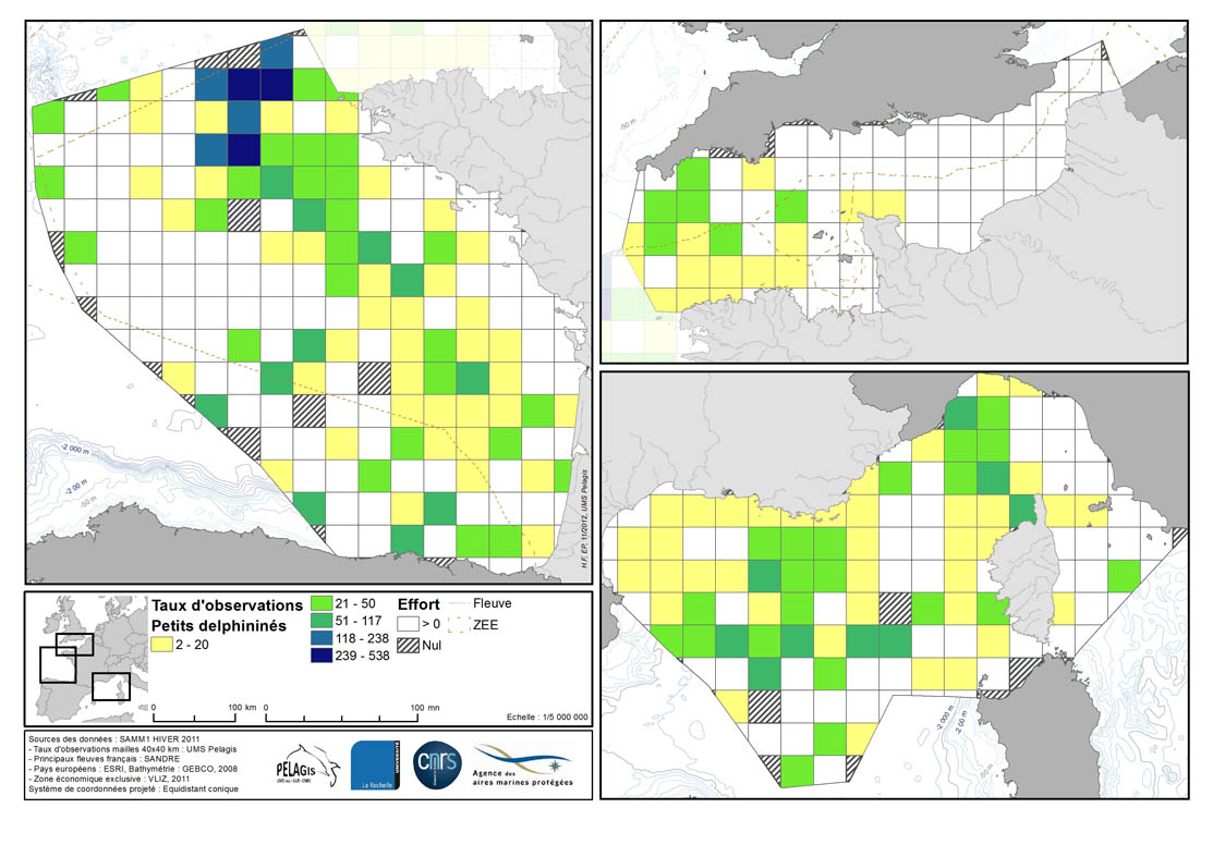
Taux de rencontre en nombre d’observation pour 1000 km d’effort dans chaque maille de 40 km de la ZEE française métropolitaine en hiver 2011/2012 et été 2012. Description de la table attributaire : survey : campagne type : type d'observation maille : taillle de la maille en kilomètre _no_maille : numéro de la maille Les champs suivant correspondent au calcul de taux de rencontre du nombre d'observation pour 1000km d'effort pour chaque espèce ou groupe d'espèce : - [marsouin] Marsouin commun - [grdDauph] Grand dauphin - [lagenor] Lagénorhynque à bec blanc - [pttDelph] : dauphin commun + dauphin bleu et blanc - [globiceph] : Globicephale noir + dauphin de Risso - [cakobab] : cachalot macrocéphale + kogias + baleines à bec - [balenopt] : rorqual commun + petit rorqual + baleine bleue - [phoque] Phoques (gris + veau-marin)
-
La donnée associée met en évidence les observations réalisées lors de la campagne d'acquisition de données d'Observation sur plateforme aérienne SAMM1 (Suivi aérien de la Mégafaune Marine) réalisée par l'Observatoire PELAGIS.
-
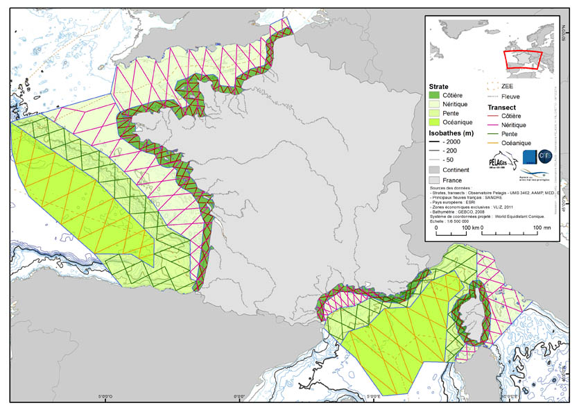
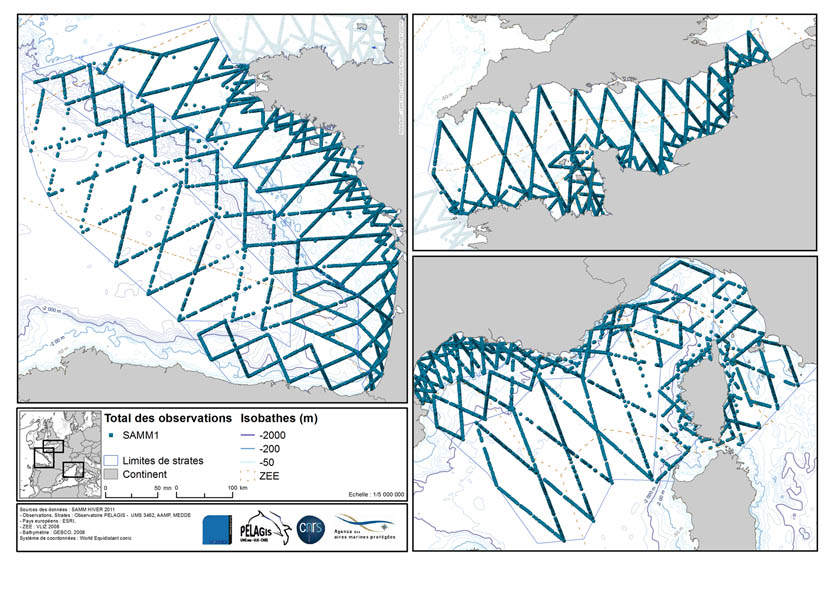
La donnée associée met en évidence le plan d'échantillonnage de la campagne d'acquisition de données d'Observation sur plateforme aérienne de la campagne SAMM1 et SAMM2 (Suivi aérien de la Mégafaune Marine) réalisée par l'Observatoire PELAGIS (UMS 3462 ULR/CNRS). Le plan d'échantillonnage est constitué des strates d'échantillonnage et des transects prévus. Ils ont été élaborées en fonction de caractéristiques spécifiques à la région d'étude "France Métropolitaine" FrM. Description des champs et valeurs de la tables attributaires : ( - nom champ, signification : valeur, description des valeurs) region char 5 Zone d'étude region_lbl char 50 Zone d'étude libellé idCampagne (survey) char 15 Nom de la campagne programme char 20 Nom du programme sector char 10 Secteur d'échantillonnage identifiant court strate char 5 Strate d'échantillonnage identifiant court strate_lbl char 15 Strate d'échantillonnage libellé areaKM double Superficie de la strate transect_name char 10 Transect d'échantillonnage length_km double Longueur du transect start_x double Coordonnées de début du transect x en degré décimal start_y double Coordonnées de début du transect y en degré décimal end_x double Coordonnées de fin du transect x en degré décimal end_y double Coordonnées de fin du transect y en degré décimal