 Catalogue PIGMA
Tides
Type of resources
Available actions
Topics
Keywords
Contact for the resource
Provided by
Years
Formats
Representation types
Update frequencies
status
Scale
Resolution
-
Auxiliary products - Tide elevations, Tide currents, Tide loading
-

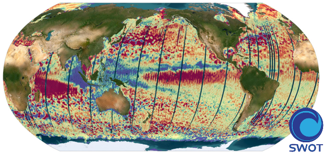
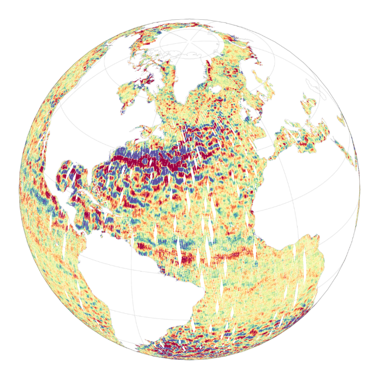
Product of simulated SWOT sea surface heights from its 2 altimeters: KaRIn interferometric altimeter and Nadir altimeter. This product includes the Level-2 Low Rate (LR) data (L2_LR_SSH) designed for ocean surfaces and Level-2 and Level-3 SSH corrected by estimations of simulated errors.
-
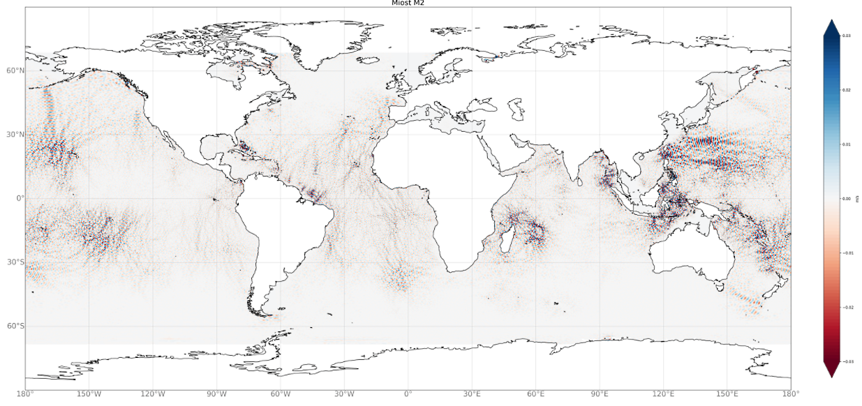
Multivariate Inversion of Ocean Surface Topography- Internal Tide (MIOST-IT) Model products. MIOST-IT database includes 4 tidal components for the ocean internal tide surface elevations. Each tidal component is described by 2 grids (amplitude and phase) provided on a cartesian grid 1/10°x1/10°. - The internal tide elevations for the four tidal frequencies M2, S2, K1, O1, are available for download. - The tidal prediction code is also available to download.
-
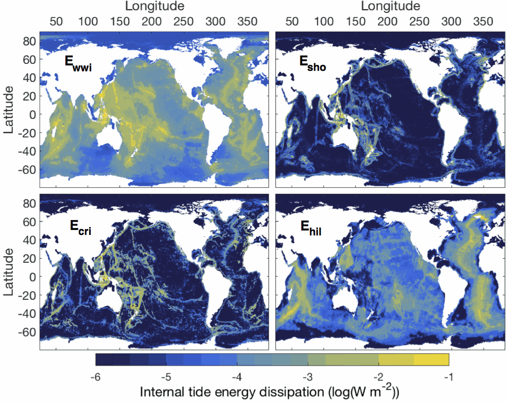
This dataset comprises two netcdf files. The first file contains the six global two-dimensional maps necessary to implement the tidal mixing parameterization presented in de Lavergne et al. (2020). Four power fields (E_wwi, E_sho, E_cri and E_hil) represent depth-integrated internal tide energy dissipation, with units of Watts per square meter. Each power field corresponds to a specific dissipative process and associated vertical structure of turbulence production. The two remaining fields, H_cri and H_bot, are decay heights (with units of meters) that enter the vertical structures of the E_cri and E_hil components, respectively. The second file contains three-dimensional fields of turbulence production (with units of Watts per kilogram) obtained by application of the parameterization to the WOCE global hydrographic climatology. The file includes the total turbulence production (epsilon_tid), its four components (epsilon_wwi, epsilon_sho, epsilon_cri, epsilon_hil), and the underlying hydrographic fields, as a function of longitude, latitude and depth. All maps have a horizontal resolution of 0.5º. Detailed documentation of the parameterization can be found in the following publication: de Lavergne, C., Vic, C., Madec, G., Roquet, F., Waterhouse, A.F., Whalen, C.B., Cuypers, Y., Bouruet-Aubertot, P., Ferron, B., Hibiya, T. A parameterization of local and remote tidal mixing. Journal of Advances in Modeling Earth Systems, 12, e2020MS002065 (2020). https://doi.org/10.1029/2020MS002065
-
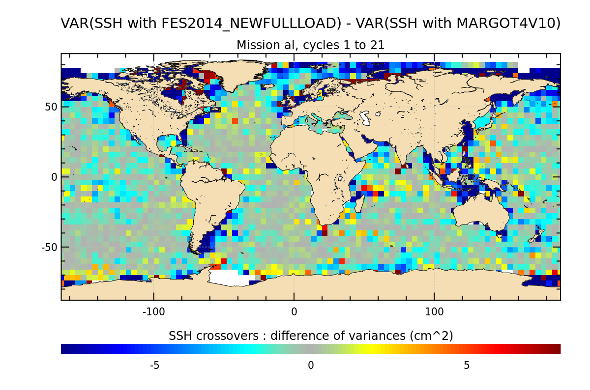
Along-track altimetric measurements averaged over 1 second, geophysical and environmental corrections to apply. Available missions are: Topex/Poseidon, Envisat, Jason-1, Jason2, Jason-3, Saral and SWOT.
-

The SWOT L3_LR_SSH product provides ocean topography measurements obtained from the SWOT KaRIn and nadir altimeter instruments, merged into a single variable. The dataset includes measurements from KaRIn swaths on both sides of the image, while the measurements from the nadir altimeter are located in the central columns. In the areas between the nadir track and the two KaRIn swaths, as well as on the outer edges of each swath (restricted to cross-track distances ranging from 10 to 60 km), default values are expected. SWOT L3_LR_SSH is a cross-calibrated product from multiple missions that contains only the ocean topography content necessary for thematic research (e.g., oceanography, geodesy) and related applications. This product is designed to be simple and ready-to-use, and can be combined with other altimetry missions. The SWOT L3_LR_SSH product is a research-orientated extension of the L2_LR_SSH product, distributed by the SWOT project (NASA/JPL and CNES) and managed by the SWOT Science Team project DESMOS. The "Basic" version of SWOT L3_LR_SSH (the "Expert" version is the subject of a separate metadata sheet) includes only the SSH anomalies and mean dynamic topography. References Dibarboure, G., Anadon, C., Briol, F., Cadier, E., Chevrier, R., Delepoulle, A., Faugère, Y., Laloue, A., Morrow, R., Picot, N., Prandi, P., Pujol, M.-I., Raynal, M., Tréboutte, A., and Ubelmann, C.: Blending 2D topography images from the Surface Water and Ocean Topography (SWOT) mission into the altimeter constellation with the Level-3 multi-mission Data Unification and Altimeter Combination System (DUACS), Ocean Sci., 21, 283–323, https://doi.org/10.5194/os-21-283-2025.
-
The SWOT L3_LR_SSH product provides ocean topography measurements obtained from the SWOT KaRIn and nadir altimeter instruments, merged into a single variable. The dataset includes measurements from KaRIn swaths on both sides of the image, while the measurements from the nadir altimeter are located in the central columns. In the areas between the nadir track and the two KaRIn swaths, as well as on the outer edges of each swath (restricted to cross-track distances ranging from 10 to 60 km), default values are expected. SWOT L3_LR_SSH is a cross-calibrated product from multiple missions that contains only the ocean topography content necessary for thematic research (e.g., oceanography, geodesy) and related applications. This product is designed to be simple and ready-to-use, and can be combined with other altimetry missions. The SWOT L3_LR_SSH product is a research-orientated extension of the L2_LR_SSH product, distributed by the SWOT project (NASA/JPL and CNES). SWOT L3_LR_SSH is managed by the SWOT Science Team project DESMOS. The ['Unsmoothed'] version of SWOT L3_LR_SSH (the "Basic" and "Expert" versions are the subject of separate metadata sheets) includes each algorithm, correction, or external model incorporated into the SWOT L3_LR_SSH product as a separate layer. This ['Unsmoothed'] version which includes the MSS, MDT and geostrophic currents (absolute and anomalies) in addition to the SSHA and MDT on the 250 m KaRIn native grid. Like the Expert subproduct, it also integrates a quality flag, corrections and external models as separate layers. References Dibarboure, G., Anadon, C., Briol, F., Cadier, E., Chevrier, R., Delepoulle, A., Faugère, Y., Laloue, A., Morrow, R., Picot, N., Prandi, P., Pujol, M.-I., Raynal, M., Tréboutte, A., and Ubelmann, C.: Blending 2D topography images from the Surface Water and Ocean Topography (SWOT) mission into the altimeter constellation with the Level-3 multi-mission Data Unification and Altimeter Combination System (DUACS), Ocean Sci., 21, 283–323, https://doi.org/10.5194/os-21-283-2025.
-

The Level-2 Ka-band Radar Interferometer (KaRIn) low rate (LR, ocean) sea surface height (SSH) data product from the Surface Water and Ocean Topography (SWOT) mission, also referenced by the short name L2_LR_SSH, provides ocean topography measurements from the low rate ocean data stream of the KaRIn instrument, spanning 60 km on either side of the nadir altimeter with a nadir gap. The L2_LR_SSH product is available continuously and globally, although different versions of the product may be produced at different latencies and/or through different reprocessing with refined input data. Note that L2_LR_SSH does not include SSH data from the SWOT nadir altimeter. SWOT launched on December 16, 2022 into a 1-day repeat orbit for the "calibration" or "fast-sampling" phase of the mission, which completed in early July 2023. After the calibration phase, SWOT entered a 21-day repeat orbit in August 2023 to start the "science" phase of the mission. The SWOT L2_LR_SSH product is organized in four files : ['Basic'], ['WindWave'], ['Expert'] and ['Unsmoothed'], each identified by its own DOI and described on a metadata sheet via the links below. - The ['Basic'] file is intended for users who are interested in SSH measurements and who will use the KaRIn measurements as provided. - The ['WindWave'] file is intended for users interested in wind and wave information. The ['Unsmoothed'] file, also intended for expert users, is provided on a finer 'native' grid of 250-m (with minimal smoothing applied), and has a significantly larger data volume than the other files. - The ['Expert'] file is intended for expert users who are interested in the details of how the KaRIn measurements were derived and who may use detailed information for their own custom processing. - The ['Unsmoothed'] file, also intended for expert users, is provided on a finer 'native' grid of 250-m (with minimal smoothing applied), and has a significantly larger data volume than the other files. Variables included: - Basic L2_LR_SSH includes corrected sea surface height (SSH), sea surface height anomaly (SSHA), data quality flags, geophysical reference fields, and height correction information on a 2 km geographically fixed grid. - WindWave L2_LR_SSH includes measured significant wave height (SWH), normalized radar cross section (NRCS or backscatter cross section or sigma0), wind speed derived from sigma0 and SWH, wind and wave model information, and quality flags on a 2 km geographically fixed grid. - Expert L2_LR_SSH, which includes copies of all variables in the Basic and WindWave files, plus more detailed information on the KaRIn instrument and environmental corrections, radiometer data, and geophysical models on a 2 km geographically fixed grid. - Unsmoothed L2_LR_SSH, which includes sea surface height (SSH) and sigma0 without additional smoothing relative to the native KaRIn downlink resolution on a ~250 m native (center-beam) grid. The Unsmoothed file contains two groups, left and right, each of which contains the data for half (one side from nadir) of the KaRIn swath. August 2024: V2.0 L2_LR_SSH version 2.0 (version C) products declared as validated by the SWOT project. March 2024: V2.0 Production and distribution of the pre-validated L2_LR_SSH version 2.0 (or version C) products: - PIC0 for forward-processed version C products: November 23, 2023 to present, - PGC0 for reprocessed version C products: - March 30 to July 10, 2023 (phase CalVal) and from July 26,2023 to January 25, 2024 (phase Science) November 2023: V1.0 The beta pre-validated L2_LR_SSH version 1.0 product (summer 2023 reprocessing release) is available only for the 1-day CalVal orbit phase, from March 29 to July 10, 2023, and the 21-day Science orbit phase from September 7 to November 21, 2023.
-
The Level-2 Ka-band Radar Interferometer (KaRIn) low rate (LR, ocean) sea surface height (SSH) data product from the Surface Water and Ocean Topography (SWOT) mission, also referenced by the short name L2_LR_SSH, provides ocean topography measurements from the low rate ocean data stream of the KaRIn instrument, spanning 60 km on either side of the nadir altimeter with a nadir gap. The L2_LR_SSH product is available continuously and globally, although different versions of the product may be produced at different latencies and/or through different reprocessing with refined input data. Note that L2_LR_SSH does not include SSH data from the SWOT nadir altimeter. The SWOT L2_LR_SSH product is organized as a collection of four files, the L2_LR_SSH ['Basic'] is described in this metadata sheet. The 3 other file types (['WindWave'], ['Expert'], ['Unsmoothed']) are described by 3 different metadata sheets that can be accessed through the links below. The ['Basic'] file on this metadata sheet, is intended for users who are interested in SSH measurements and who will use the KaRIn measurements as provided. The ['WindWave'] file is intended for users interested in wind and wave information. The ['Expert'] file is intended for expert users who are interested in the details of how the KaRIn measurements were derived and who may use detailed information for their own custom processing. The ['Unsmoothed'] file, also intended for expert users, is provided on a finer 'native' grid of 250-m (with minimal smoothing applied), and has a significantly larger data volume than the other files. The ['Basic'] L2_LR_SSH includes corrected sea surface height (SSH), sea surface height anomaly (SSHA), data quality flags, geophysical reference fields, and height correction information on a 2-km geographically fixed grid. August 2024: V2.0 L2_LR_SSH version 2.0 (version C) products declared as validated by the SWOT project. March 2024: V2.0 Production and distribution of the pre-validated L2_LR_SSH version 2.0 (or version C) products: - PIC0 for forward-processed version C products: November 23, 2023 to present, - PGC0 for reprocessed version C products: - March 30 to July 10, 2023 (phase CalVal) and from July 26,2023 to January 25, 2024 (phase Science) November 2023: V1.0 The beta pre-validated L2_LR_SSH version 1.0 product (summer 2023 reprocessing release) is available only for the 1-day CalVal orbit phase, from March 29 to July 10, 2023, and the 21-day Science orbit phase from September 7 to November 21, 2023.
-

The SWOT L3_LR_SSH product provides ocean topography measurements obtained from the SWOT KaRIn and nadir altimeter instruments, merged into a single variable. The dataset includes measurements from KaRIn swaths on both sides of the image, while the measurements from the nadir altimeter are located in the central columns. In the areas between the nadir track and the two KaRIn swaths, as well as on the outer edges of each swath (restricted to cross-track distances ranging from 10 to 60 km), default values are expected. SWOT L3_LR_SSH is a cross-calibrated product from multiple missions that contains only the ocean topography content necessary for thematic research (e.g., oceanography, geodesy) and related applications. This product is designed to be simple and ready-to-use, and can be combined with other altimetry missions. The SWOT L3_LR_SSH product is a research-orientated extension of the L2_LR_SSH product, distributed by the SWOT project (NASA/JPL and CNES). SWOT L3_LR_SSH is managed by the SWOT Science Team project DESMOS. The "Expert" version of SWOT L3_LR_SSH (the "Basic" version is the subject of a separate metadata sheet) includes each algorithm, correction, or external model incorporated into the SWOT L3_LR_SSH product as a separate layer. In addition to the SSH anomalies, this "Expert" version also includes mean dynamic topography (as in the "Basic" version), backscatter coefficient (sigma0), mean sea surface and geostrophic currents (absolute and anomalies). References Dibarboure, G., Anadon, C., Briol, F., Cadier, E., Chevrier, R., Delepoulle, A., Faugère, Y., Laloue, A., Morrow, R., Picot, N., Prandi, P., Pujol, M.-I., Raynal, M., Tréboutte, A., and Ubelmann, C.: Blending 2D topography images from the Surface Water and Ocean Topography (SWOT) mission into the altimeter constellation with the Level-3 multi-mission Data Unification and Altimeter Combination System (DUACS), Ocean Sci., 21, 283–323, https://doi.org/10.5194/os-21-283-2025.