 Catalogue PIGMA
Turbidity
Type of resources
Available actions
Topics
Keywords
Contact for the resource
Provided by
Years
Formats
Representation types
Update frequencies
status
Scale
-

As part of the marine water quality monitoring of the “Pertuis” and the “baie de l’Aiguillon” (France), commissioned by the OFB and carried out by setec énergie environnement, three monitoring stations were installed. Two of them were set up at the mouths of the Charente and Seudre rivers on February 6 and 27, 2019, respectively, while a third was deployed in the Bay of Aiguillon on March 24, 2021. The dataset presented here concerns the station installed in the Charente estuary. Measurements are organized into .csv files, with one file per year. Data is collected using a SAMBAT multiparameter probe, which records the following parameters: - Temperature (-5 to 35 °C) - Conductivity (0 to 10 mS/cm) - Pressure (0 to 10 m) - Turbidity (0 to 300 NTU) - Dissolved Oxygen (0 to 20 mg/L & 0 to 200 %) - Fluorescence (0 to 50 µg/l) - PH (0/14)
-

As part of the marine water quality monitoring of the “Pertuis” and the “baie de l’Aiguillon” (France), commissioned by the OFB and carried out by setec énergie environnement, three monitoring stations were installed. Two of them were set up at the mouths of the Charente and Seudre rivers on February 6 and 27, 2019, respectively, while a third was deployed in the Bay of Aiguillon on March 24, 2021. The dataset presented here concerns the station installed in the Bay of Aiguillon. Measurements are organized into .csv files, with one file per year. Data is collected using a WiMO multiparameter probe, which records the following parameters: • Temperature (-2 to 35 °C) • Conductivity (0 to 100 mS/cm) • Pressure (0 to 30 m) • Turbidity (0 to 4000 NTU) • Dissolved Oxygen (0 to 23 mg/L & 0 to 250 %) • Fluorescence (0 to 500 ppb)
-
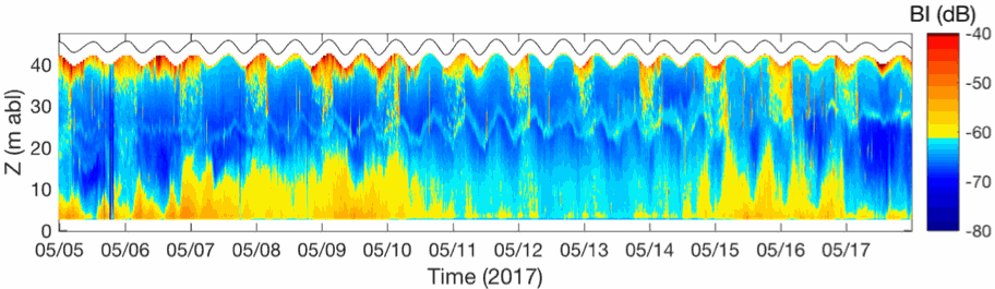
In the framework of the ANR AMORAD project, the METEOR cruises (Grasso, 2017) aimed at deploying the ‘Gironde Estuary Mouth MEasurement Stations’ (GEMMES) to measure hydrodynamics and sediment dynamics at the mouth of the Gironde Estuary and on the West Gironde Mud Patch (SW France, Bay of Biscay). Measurements were carried out between November 2016 and December 2017: i) from a buoy station around 20-m water depth (GEMMES-20), collecting sub-surface data of temperature, salinity and turbidity; and ii) a benthic station around 40-m water depth (GEMMES-40), collecting data of current velocity and turbidity. Bottom and surface water samples were regularly collected to calibrate turbidity measurements to SPM concentrations.
-
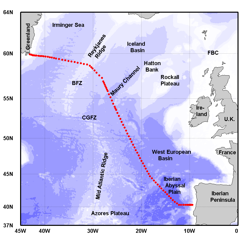
The Greenland-Portugal A25 OVIDE line is carried out biennially since 2002. The section is composed of 98 stations where hydrographic, biogeochemical and current measurements are carried out down to the bottom. OVIDE is a contribution to the international programs Go-Ship, IOCCP, and CLIVAR. This data set contains the final (adjusted) CTDO2 data.
-
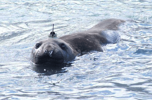
The Southern Ocean plays a fundamental role in regulating the global climate. This ocean also contains a rich and highly productive ecosystem, potentially vulnerable to climate change. Very large national and international efforts are directed towards the modeling of physical oceanographic processes to predict the response of the Southern Ocean to global climate change and the role played by the large-scale ocean climate processes. However, these modeling efforts are greatly limited by the lack of in situ measurements, especially at high latitudes and during winter months. The standard data that are needed to study ocean circulation are vertical profiles of temperature and salinity, from which we can deduce the density of seawater. These are collected with CTD (Conductivity-Temperature-Depth) sensors that are usually deployed on research vessels or, more recently, on autonomous Argo profilers. The use of conventional research vessels to collect these data is very expensive, and does not guarantee access to areas where sea ice is found at the surface of the ocean during the winter months. A recent alternative is the use of autonomous Argo floats. However, this technology is not easy to use in glaciated areas. In this context, the collection of hydrographic profiles from CTDs mounted on marine mammals is very advantageous. The choice of species, gender or age can be done to selectively obtain data in particularly under-sampled areas such as under the sea ice or on continental shelves. Among marine mammals, elephant seals are particularly interesting. Indeed, they have the particularity to continuously dive to great depths (590 ± 200 m, with maxima around 2000 m) for long durations (average length of a dive 25 ± 15 min, maximum 80 min). A Conductivity-Temperature-Depth Satellite Relay Data Logger (CTD-SRDLs) has been developed in the early 2000s to sample temperature and salinity vertical profiles during marine mammal dives (Boehme et al. 2009, Fedak 2013). The CTD-SRDL is attached to the seal on land, then it records hydrographic profiles during its foraging trips, sending the data by satellite ARGOS whenever the seal goes back to the surface.While the principle intent of seal instrumentation was to improve understanding of seal foraging strategies (Biuw et al., 2007), it has also provided as a by-product a viable and cost-effective method of sampling hydrographic properties in many regions of the Southern Ocean (Charrassin et al., 2008; Roquet et al., 2013).
-
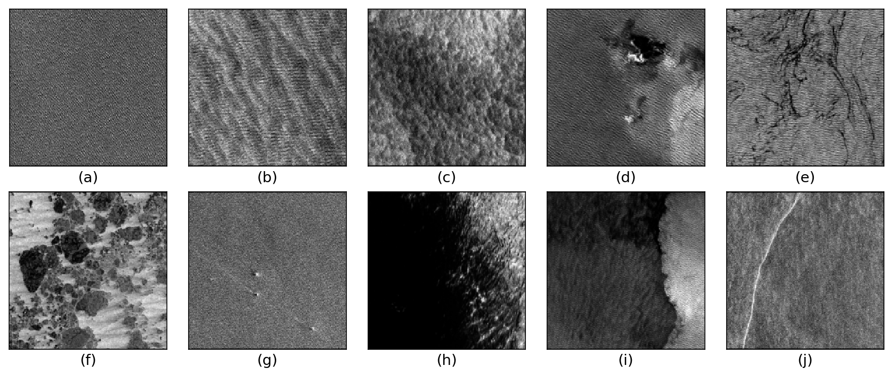
The TenGeoP-SARwv dataset is established based on the acquisitions of Sentinel-1A wave mode (WV) in VV polarization. This dataset consists of more than 37,000 SAR vignettes divided into ten defined geophysical categories, including both oceanic and meteorologic features. These images cover the entire open ocean and are manually selected from Sentinel-1A WV acquisitions in 2016. For each image, only one prevalent geophysical phenomena with its prescribed signature and texture is selected for labeling. The SAR images are processed into a quick-look image provided in the formats of PNG and GeoTIFF as well as the associated labels. They are convenient for both visual inspection and machine-learning-based methods exploitation. The proposed dataset is the first one involving different oceanic or atmospheric phenomena over the open ocean. It seeks to foster the development of strategies or approaches for massive ocean SAR image analysis. A key objective is to allow exploiting the full potential of Sentinel-1 WV SAR acquisitions, which are about 60,000 images per satellite per month and freely available. Such a dataset may be of value to a wide range of users and communities in deep learning, remote sensing, oceanography, and meteorology
-
The Everyone's Gliding Observatories (EGO) initiative is a gathering of several teams of oceanographers, interested in developing the use of gliders for ocean observations. EGO started in Europe with members from France, Germany, Italy, Norway, Spain, and the United Kingdom. The partners of EGO have been funded by both European and national agencies to operate gliders for various purposes and at different sites. Coordinated actions are being set up for these sites in order to demonstrate the capabilities of a fleet of gliders for sampling the ocean, with a given scientific and/or operational objective. Gliders were developed since the 90’s to carry out in-situ observations of the upper 1km of the ocean, filling the gaps left by the existing observing systems. Gliders look like small autonomous robotic underwater vehicles which that uses an engine to change their buoyancy. While gliding from surface to about 1000 meters, gliders provide real-time physical and biogeochemical data along their transit. They observe temperature, salinity, pressure, biogeochemical data or acoustic data.
-
The ARCHYD dataset, which have been collected since 1988, represents the longest long-term hydrologic data sets in Arcachon Bay. The objectives of this monitoring programme are to assess the influence of oceanic and continental inputs on the water quality of the bay and their implications on biological processes. It also aims to estimate the effectiveness of management policies in the bay by providing information on trends and/or shifts in pressure, state, and impact variables. Sampling is carried on stations spread across the entire bay, but since 1988, the number and location of stations have changed slightly to better take into account the gradient of ocean and continental inputs. In 2005, the ARCHYD network was reduced to 8 stations that are still sampled by Ifremer to date. All the stations are sampled at a weekly frequency, at midday, alternately around the low spring tide and the high neap tide. Data are complementary to REPHY dataset. Physico-chemical measures include temperature, salinity, turbidity, suspended matters (organic, mineral), dissolved oxygen and dissolved inorganic nutrients (ammonium, nitrite+nitrate, phosphate, silicate). Biological measures include pigment proxies of phytoplankton biomass and state (chlorophyll a and phaeopigment).
-
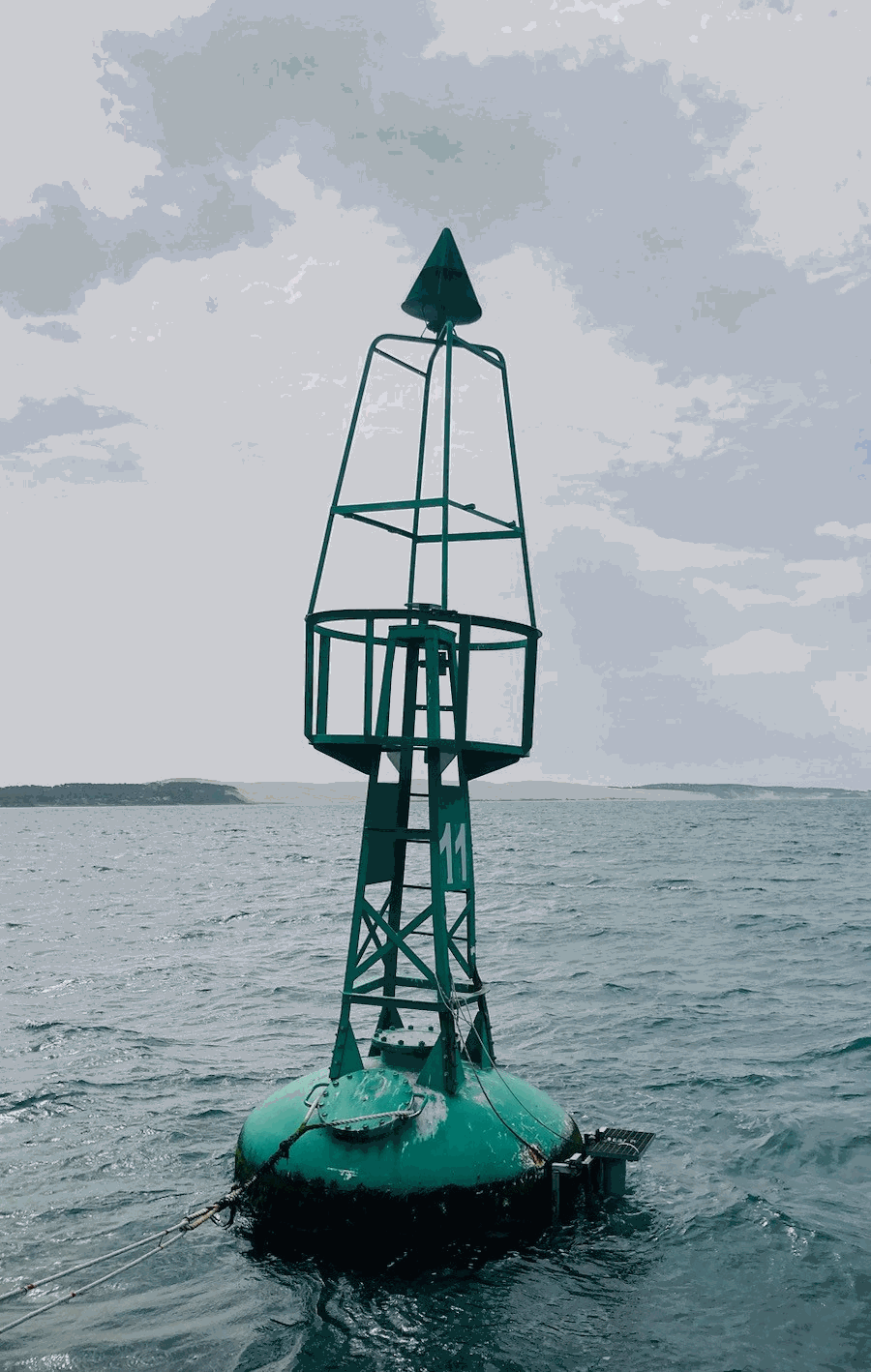
The COAST-HF/Arcachon-Ferret time series characterizes the hydrology of the interface between the Arcachon lagoon, located in the South-Western France, and the Atlantic Ocean. A buoy belonging to Phares et Balises is instrumented with a multi-parametric probe that records sub-surface temperature, conductivity, depth, turbidity and fluorescence every 10 minutes since February 2018. It is opérated by the OASU and EPOC teams (Univ. Bordeaux/CNRS). COAST-HF (Coastal OceAn observing SysTem - High Frequency; www.coast-hf.fr) is a national observation network accredited by the CNRS as a national Earth Science Observatory (Service National d’Observation: SNO). It aims to federate and coordinate a set of 14 fixed platforms instrumented with high-frequency in situ measurements for key parameters of coastal waters. The COAST-HF/Arcachon-Ferret buoy is one of them. COAST-HF is part of the French Research Infrastructure dedicated to coastal ocean observations (RI ILICO, https://www.ir-ilico.fr). Data are transmitted to the Coriolis Côtier database (https://data.coriolis-cotier.org/). Data are raw data.
-
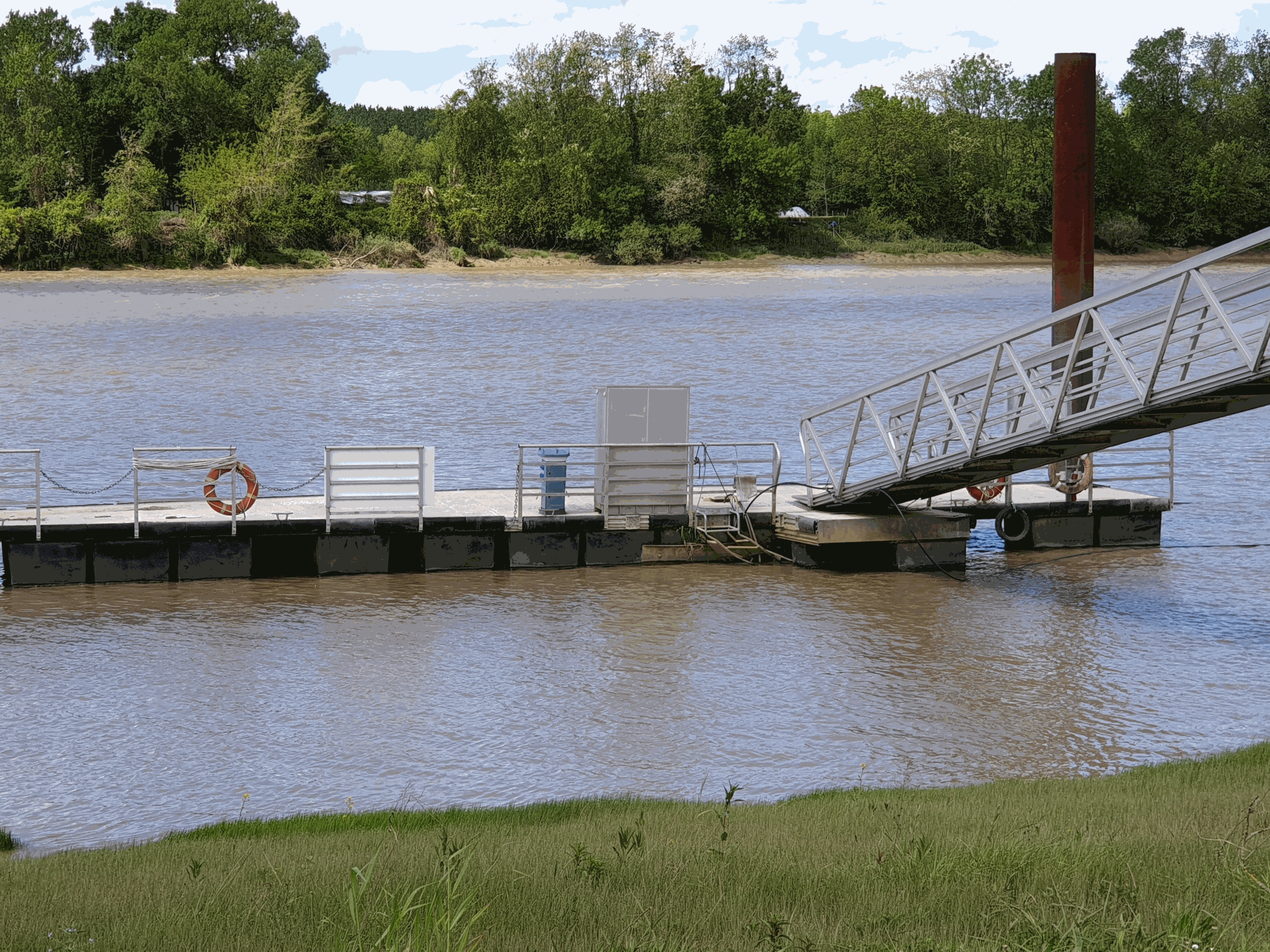
The French Atlantic coast hosts numerous macrotidal and turbid estuaries that flow into the Bay of Biscay that are natural corridors for migratory fishes. The two best known are those of the Gironde and the Loire. However, there are also a dozen estuaries set geographically among them, of a smaller scale. The physico-chemical quality of estuarine waters is a necessary support element for biological life and determines the distribution of species, on which many ecosystem services (e.g. professional or recreational fishing) depend. With rising temperatures and water levels, declining precipitation and population growth projected for the New Aquitaine region by 2030, the question of how the quality and ecological status of estuarine waters will evolve becomes increasingly critical. The MAGEST (Mesures Automatisées pour l’observation et la Gestion des ESTuaires nord aquitains) high-frequency monitoring of key physico-chemical parameters was first developed in the Gironde estuary in 2004 ; the Seudre and Charente estuaries were instrumented late 2020. First based on real-time automated systems, MAGEST is now equipped by autonomous multiparameter sensors. Depending of the stations, an optode is also deployed to secure dissolved oxygen measurement. By the end of 2020, MAGEST had 12 instrumented sites. Portets is a measuring station located in the upper Gironde estuary (Garonne subestuary, about 20 km upstream of the Bordeaux metropolis.