 Catalogue PIGMA
dissolved oxygen
Type of resources
Available actions
Topics
Keywords
Contact for the resource
Provided by
Years
Formats
-
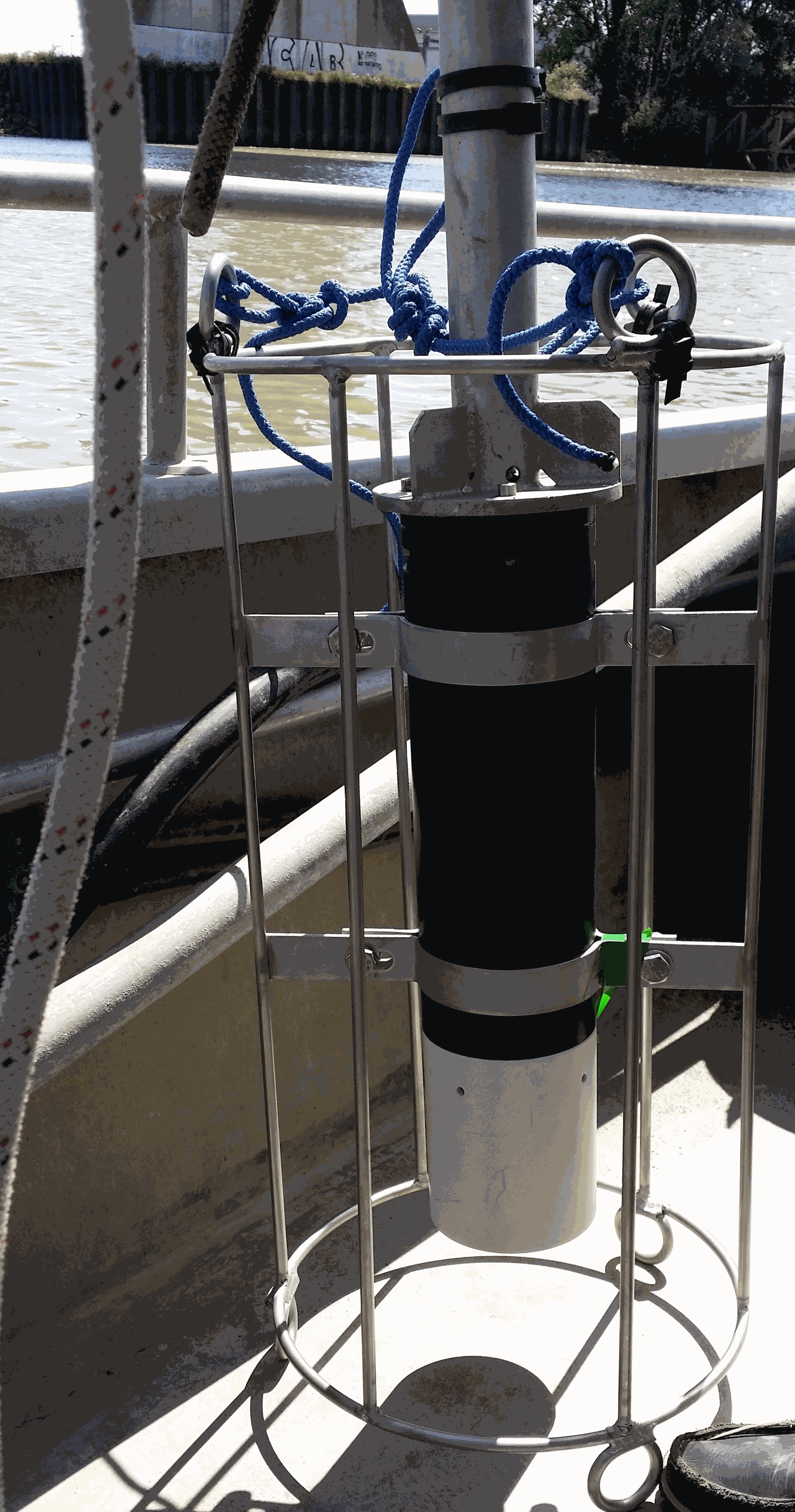
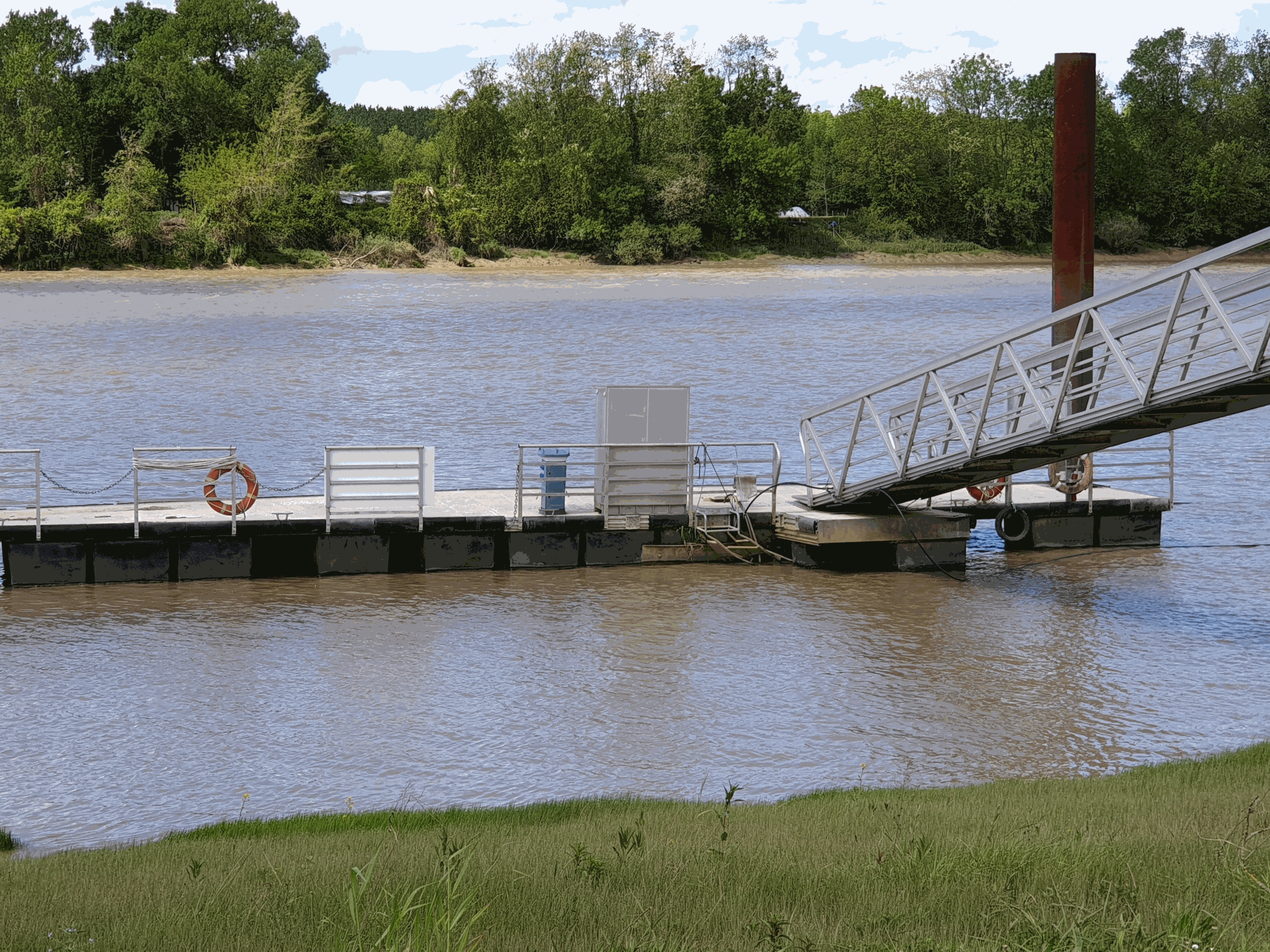
Key physico-chemical parameters (salinity, temperature, turbidity and dissolved oxygen) were measured in surface water during longitudinal transects in the Loire and Gironde estuaries in summers 2017 and 2018. This objective of this work was to determine the distribution of the dissolved oxygen and to detect potential severe desoxygenation. The transects were scheduled in order to begin the measurements at high tide from a site located upstream of an area where severe deoxygenation have been already been reported. Then, the transect was realised by sailing at low speed downstream with a multiparameter probe SAMBAT, maintained at 0.5 m below the surface, that collected a measurement every 2 minutes.
-
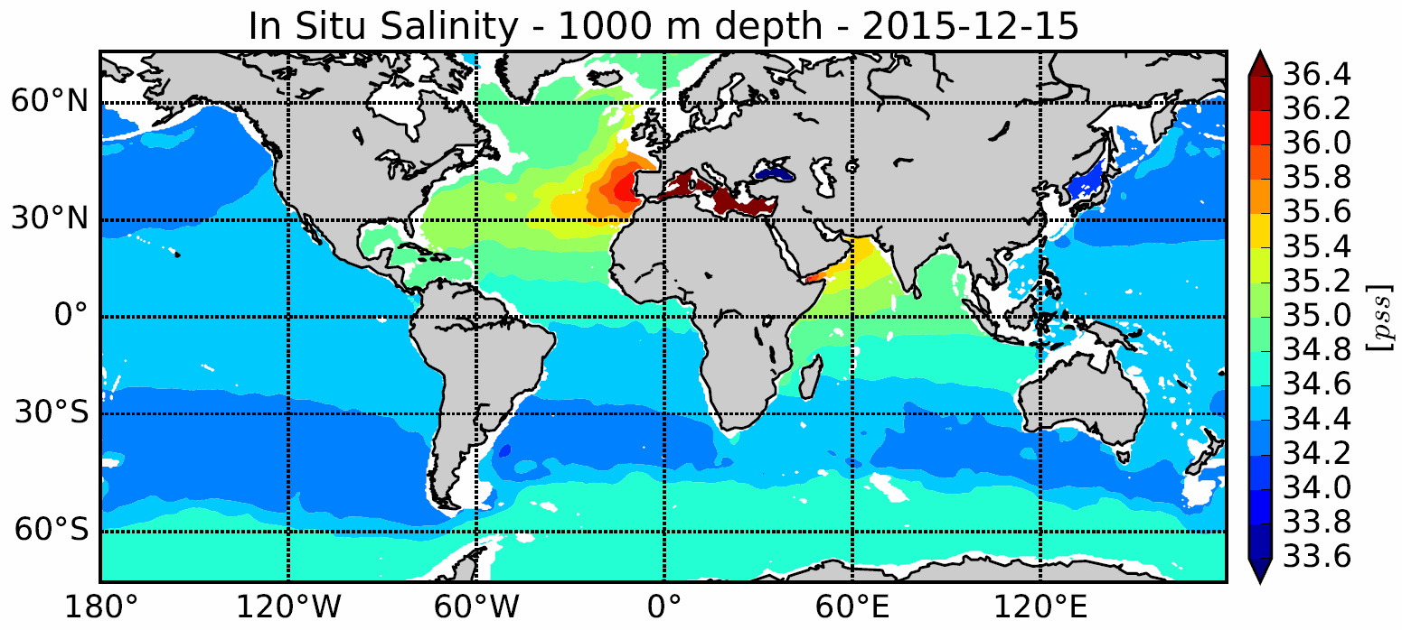
The In Situ Analysis System (ISAS) was developed to produce gridded fields of temperature and salinity that preserve as much as possible the time and space sampling capabilities of the Argo network of profiling floats. ISAS is based on Optimal Interpolation method. Since the first global re-analysis performed in 2009, the system has been extended to accommodate all types of vertical profile as well as time series. ISAS gridded fields are entirely based on in-situ measurements. The system aims at monitoring the time evolution of ocean properties for climatic studies and allowing easy computation of climate indices. Delayed Mode (D) profiles are used a much as possible and extra visual check is carried out. The ISAS procedure and products are described in Gaillard et al. (2016). The present DOI provides both analyzed fields and standardized profiles data used in interpolation. ISAS provide now also gridded fields of dissolved oxgyen from BGC Argo floats. HISTORY ISAS20_ARGO_*_DOXY: The ISAS20_ARGO_*_DOXY release is BGC Argo DOXY variable interpolated on 187 standard depth levels between 0-5500 m depth and 0.5°x0.5° global horizontal grid. ISAS20 use the version 8 of ISAS and updated statistics to produce the monthly analysis (Monthly Climatology and annual STD computed from WOA18A5B7). ISAS20 gridded fields analyze yearly mean of the Argo dissolved oxygen data over 3 periods : 2009-2018, 2009-2013, and 2014-2018. ISAS20_ARGO: The ISAS20_ARGO release is interpolated on 187 standard depth levels between 0-5500 m depth and 0.5°x0.5° global horizontal grid. ISAS20 use the version 8 of ISAS and updated statistics to produce the monthly analysis (Monthly Climatology and annual STD computed from WOA18A5B7). ISAS20 gridded fields analyze the Argo and Deep-Argo temperature and salinity data alone between 2002-2020. ISAS17: The ISAS17 release is interpolated on 187 standard depth levels between 0-5500 m depth and 0.5°x0.5° global horizontal grid. ISAS17 use the version 8 of ISAS and updated statistics to produce the monthly analysis (Monthly Climatology and annual STD computed from WOA18A5D). ISAS17 gridded fields analyze the Argo and Deep-Argo temperature and salinity profiles, and other in situ measurements between 2002-2017 to complete observations, including the higher latitudes (typically poleward of 60°S-N) where Argo sampling is sparse or not existent. ISAS-SSS : The ISAS-SSS release is interpolated on 4 standard depth levels (1-3-5-10m depth) and 0.5°x0.5° global horizontal grid between 2002-2015. ISAS-SSS use the version 7 of ISAS and updated the statistics to produce the monthly analyses (Monthly Climatology computed from ISAS13 and annual STD computed from Argo dataset). ISAS-SSS gridded fields analyze the Argo and other in situ salinity data, including TSG from research and ship of opportunity from French SNO-SSS. ISAS15 : The ISAS15 release is interpolated on 152 standard depth levels between 0-2000 m depth and 0.5°x0.5° global horizontal grid between 2002-2015. ISAS15 use the version 7 of ISAS and updated statistics to produce the monthly analysis (Monthly Climatology computed from ISAS13 and annual STD computed from Argo dataset). ISAS15 gridded fields analyze the Argo temperature and salinity data alone in its ISAS15_ARGO configuration; or Argo plus other in situ measurements in its ISAS15 configuration. ISAS13 : The ISAS13 release is interpolated on 152 standard depth levels between 0-2000 m depth and 0.5°x0.5° global horizontal grid between 2002-2012. ISAS13 use the version 6 of ISAS and updated statistics to produce the monthly analysis (Monthly Climatology computed from ISAS11 and annual STD computed from Argo dataset). ISAS13 gridded fields analyze the Argo temperature and salinity data and other in situ measurements between 2002-2012. For detailed information and description of the ISAS products please visit the dedicated Argo France web page: https://www.argo-france.fr/Argo-Data-Products/Argo-France-products
-
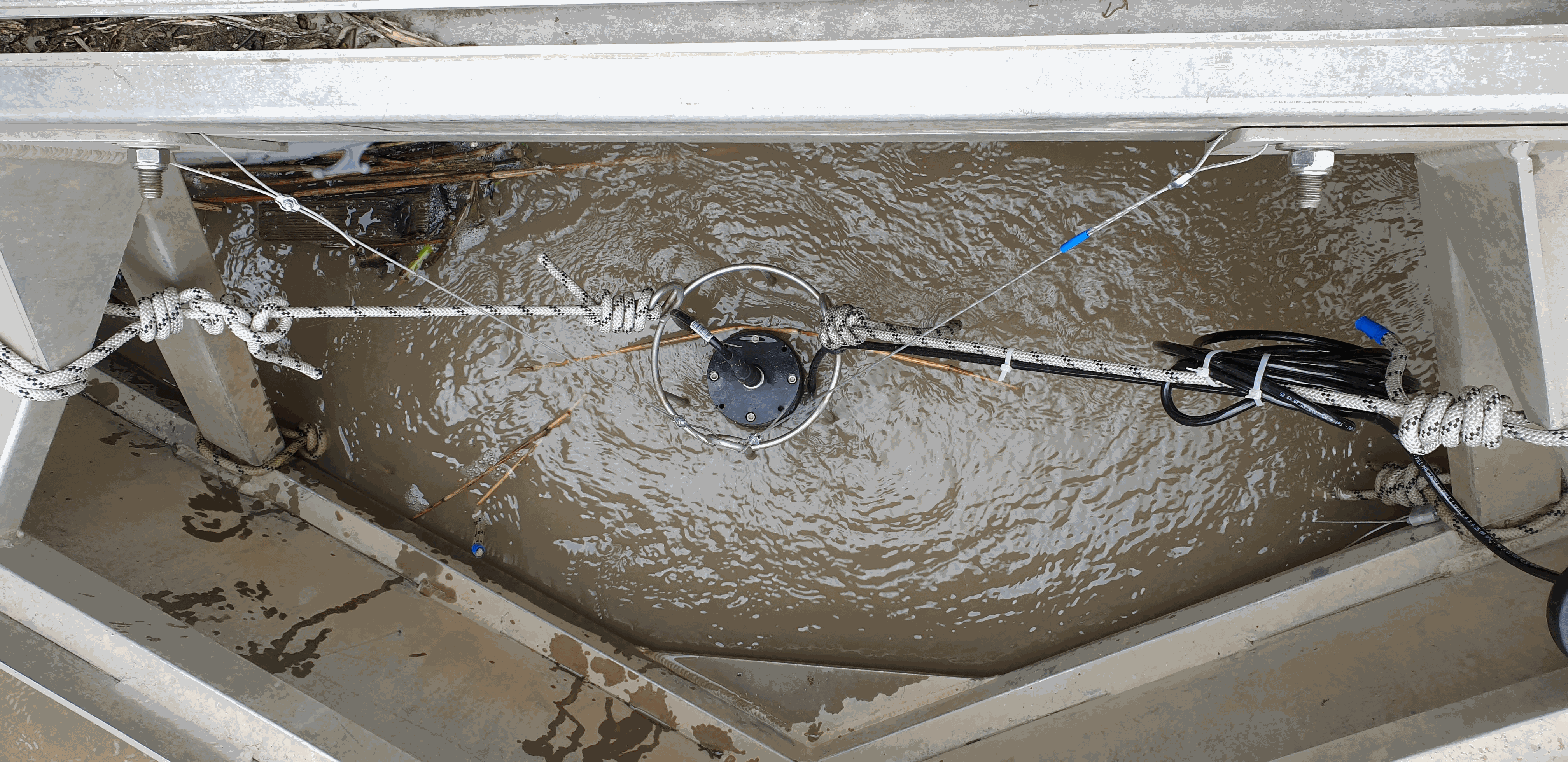
There are at least a dozen small hyper-turbid estuaries facing the Bay of Biscay, geographically situated between the two major estuaries of the Gironde and the Loire. MAGEST and SYVEL high-frequency multi-site monitoring revealed that the Loire, and to a lesser extent the Gironde, are subject to summer hypoxia. These observations raised the question of the potential occurrence of hypoxia in the small estuaries in between, motivating an investigation of dissolved oxygen in one of them, the Charente estuary. Oxygen and salinity sensors were placed at L'Houmée (2019), Tonnay-Charente (2018; 2019), Rochefort (2020; 2021; 2022), Martrou (2020) during summer, the most critical period for dissolved oxygen; a multiparameter probe was placed at Tonnay-Charente from April to November 2020. Longitudinal investigations along the estuary axis were also carried out during the summers of 2018 and 2019. All the measurements were acquired at 0.5 ± 0.2 meters below the surface. The dataset enabled us to identify the occurrence of summer hypoxia and an oxygen depletion zone in the Charente estuary. These results resulted in the implementation of high-frequency monitoring at Tonnay-Charente, operational since November 2020.
-
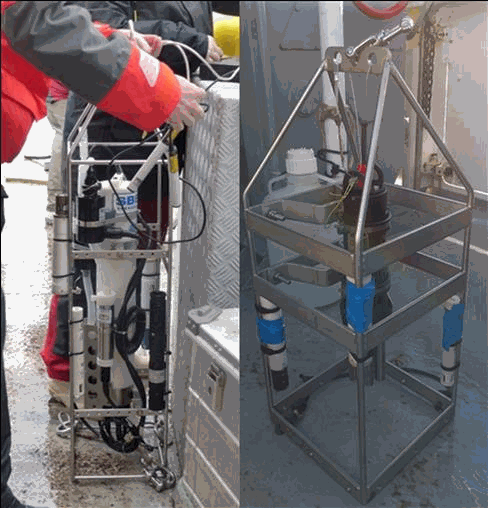
The aim of this work was to document the seasonal and inter-annual dynamic of dissolved oxygen and ancillary data (T, S, Chl-a, turbidity, pH) along a cross-shelf transect off the Gironde estuary. This work has been motivated by recent simulations that suggest the occurrence of seasonal bottom deoxygenations in this River-dominated Ocean Margin (Riomar); but unfortunately there were no data sets to test this hypothesis until now. Profiles of temperature, salinity and dissolved oxygen were performed in the water column of the West Gironde Mud Patch off the Gironde estuary (from 45°46.383’N – 1°28.925’W to 45°35.524’N - 1°50.689’W) during seven cruises on the R/V Côte de la Manche (doi: 10.18142/284 ; 10.17600/18000861) between 2016 and 2021 (October 2016, August 2017, January 2018, April 2018, July 2019, April 2021, October 2021). Turbidity was measured in January and April 2018, July 2019 and October 2021, Chl-a in October 2016, August 2017, January 2018, April 2018 and July 2019 and pH in October 2021. This dataset had permitted to validate the occurrence of bottom deoxygenations when the water column is stratified.
-
The French Atlantic coast hosts numerous macrotidal and turbid estuaries that flow into the Bay of Biscay that are natural corridors for migratory fishes. The two best known are those of the Gironde and the Loire. However, there are also a dozen estuaries set geographically among them, of a smaller scale. The physico-chemical quality of estuarine waters is a necessary support element for biological life and determines the distribution of species, on which many ecosystem services (e.g. professional or recreational fishing) depend. With rising temperatures and water levels, declining precipitation and population growth projected for the New Aquitaine region by 2030, the question of how the quality and ecological status of estuarine waters will evolve becomes increasingly critical. The MAGEST (Mesures Automatisées pour l’observation et la Gestion des ESTuaires nord aquitains) high-frequency monitoring of key physico-chemical parameters was first developed in the Gironde estuary in 2004 ; the Seudre and Charente estuaries were instrumented late 2020. First based on real-time automated systems, MAGEST is now equipped by autonomous multiparameter sensors. Depending of the stations, an optode is also deployed to secure dissolved oxygen measurement. By the end of 2020, MAGEST had 12 instrumented sites. Portets is a measuring station located in the upper Gironde estuary (Garonne subestuary, about 20 km upstream of the Bordeaux metropolis.