 Catalogue PIGMA
fish
Type of resources
Available actions
Topics
Keywords
Contact for the resource
Provided by
Years
Formats
Representation types
-
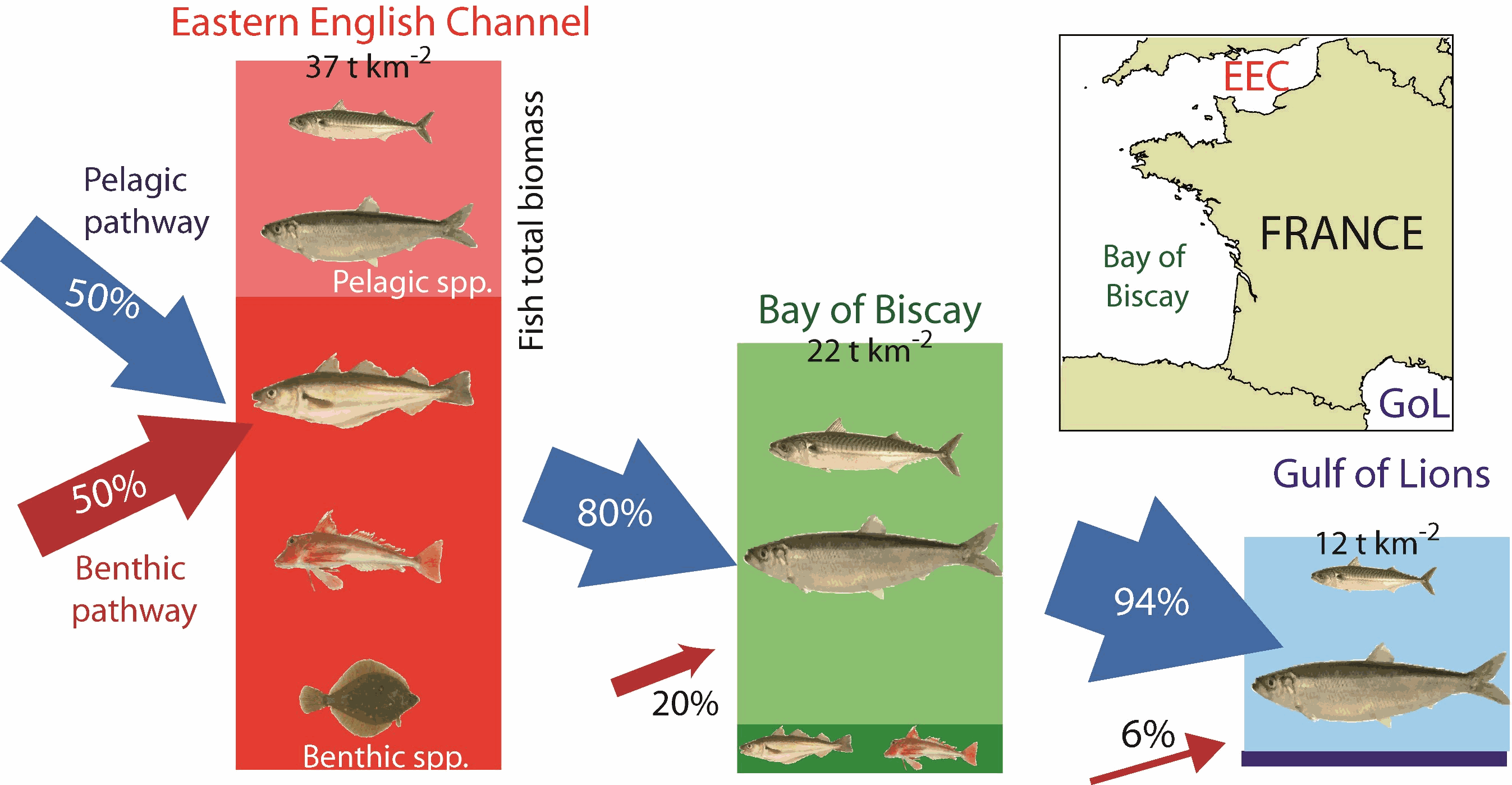
This dataset gathers data used to infer the trophic structure and functioning of fish assemblages in the Eastern English Channel, the Bay of Biscay and the Gulf of Lions : - Biomass data, resulting from accoustic monitoring for pelagic species, or bottom trawling for demersal species, after extrapolation based on stratification scheme - Individual C and N isotopic ratios, length and mass, for all individuals considered - Individual energetic density values
-
EMODnet Biology provides three keys services and products to users. 1)The data download toolbox allows users to explore available datasets searching by source, geographical area, and/or time period. Datasets can be narrowed down using a taxonomic criteria, whether by species group (e.g. benthos, fish, algae, pigments) or by both scientific and common name. 2) The data catalogue is the easiest way to access nearly 1000 datasets available through EMODnet Biology. Datasets can be filtered by multiple parameters via the advanced search from taxon, to institute, to geographic region. Each of the resulting datasets then links to a detailed fact sheet containing a link to original data provider, recommended citation, policy and other relevant information. Data Products - EMODnet Biology combines different data from datasets with overlapping geographic scope and produces dynamic maps of selected species abundance. The first products are already available and they focus on species whose data records are most complete and span for a longer term.
-
The European Ocean Biogeographic Information System - EurOBIS - is an online marine biogeographic database compiling data on all living marine creatures. The principle aims of EurOBIS are to centralize the largely scattered biogeographic data on marine species collected by European institutions and to make these data freely available and easily accessible. All data go through a number of quality control procedures before they are made available online, assuring a minimum level of quality necessary to put the data to good use. The available data are either collected within European marine waters or by European researchers and institutes outside Europe. The database focuses on taxonomy and distribution records in space and time; all data can be searched and visualised through a set of online mapping tools. All data are freely available online and easily accessible, without requiring a login or password.
-
The International Council for the Exploration of the Sea (ICES), is a global organization that develops science and advice to support the sustainable use of the oceans. ICES is a network of more than 5,000 scientists from over 690 marine institutes in 20 member countries and beyond. 1,500 scientists participate in our activities annually. ICES has a well-established Data Centre, which manages a number of large dataset collections related to the marine environment. The majority of data – covering the Northeast Atlantic, Baltic Sea, Greenland Sea, and Norwegian Sea – originate from national institutes that are part of the ICES network. The ICES Data Centre provides marine data services to ICES member countries, expert groups, world data centres, regional seas conventions (HELCOM and OSPAR), the European Environment Agency (EEA), Eurostat, and various other European projects and biodiversity portals. ICES aims to provide all data collections online and according to the ICES Data policy, which enables open access to all data that are do not fall under specific commercial or personal privacy concerns.