 Catalogue PIGMA
in-situ
Type of resources
Available actions
Topics
Keywords
Contact for the resource
Provided by
Representation types
Update frequencies
status
Scale
-
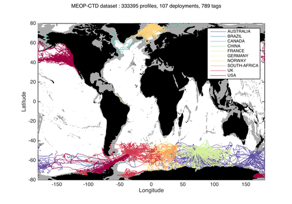
Since 2004, several hundred seals have been equipped with conductivity-temperature-depth (CTD) sensors in the Southern Ocean for both biological and physical oceanographic studies. A calibrated collection of seal-derived hydrographic data is now available from Coriolis, currently consisting of more than 300,000 temperature/salinity profiles. Delayed mode data, December 2014 https://doi.org/10.12770/0a82d60c-683d-47b8-8bd1-24933ec24983 on the Coriolis ftp server, in /ifremer/marine_mammals/. In a near future (summer 2015), seal data will be updated daily, and a monthly snapshot of the full database will be produced. through the Coriolis data selection tool (Sea mammal or Animal profiles).
-
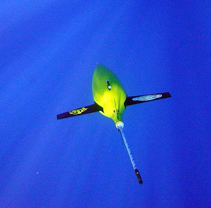
The Everyone's Gliding Observatories (EGO) initiative is a gathering of several teams of oceanographers, interested in developing the use of gliders for ocean observations. EGO started in Europe with members from France, Germany, Italy, Norway, Spain, and the United Kingdom. The partners of EGO have been funded by both European and national agencies to operate gliders for various purposes and at different sites. Coordinated actions are being set up for these sites in order to demonstrate the capabilities of a fleet of gliders for sampling the ocean, with a given scientific and/or operational objective. Gliders were developed since the 90’s to carry out in-situ observations of the upper 1km of the ocean, filling the gaps left by the existing observing systems. Gliders look like small autonomous robotic underwater vehicles which that uses an engine to change their buoyancy. While gliding from surface to about 1000 meters, gliders provide real-time physical and biogeochemical data along their transit. They observe temperature, salinity, pressure, biogeochemical data or acoustic data.
-
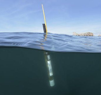
Argo is a global array of 3,000 free-drifting profiling floats that measures the temperature and salinity of the upper 2000 m of the ocean. This allows, for the first time, continuous monitoring of the temperature, salinity, and velocity of the upper ocean, with all data being relayed and made publicly available within hours after collection. The array provides 100,000 temperature/salinity profiles and velocity measurements per year distributed over the global oceans at an average of 3-degree spacing. Some floats provide additional bio-geo parameters such as oxygen or chlorophyll. All data collected by Argo floats are publically available in near real-time via the Global Data Assembly Centers (GDACs) in Brest (France) and Monterey (California) after an automated quality control (QC), and in scientifically quality controlled form, delayed mode data, via the GDACs within six months of collection.