sea level
Type of resources
Available actions
Topics
Keywords
Contact for the resource
Provided by
Years
Formats
Representation types
Update frequencies
status
Scale
Resolution
-
Shom manages a network of permanent digital coastal tide-gauges on French coasts: the RONIM Sea Level Observation Network. Most tide-gauge observatories are partnered with one or more local partners.<br /><br /> Four main types of data are available for download:<br /> - “Raw high frequency" data: raw observations neither validated nor evaluated, obtained directly from the sensor. 1-minute measurement; integration time 15 seconds (on the minute); sampling period: 1 second.<br /><br /> - "Raw non-real time" data: raw observations neither validated nor evaluated, obtained directly from the sensor. 10-minute measurement; integration time 121 seconds (around every 10 minutes); sampling period: 1 second.<br /><br /> - "Validated non-real time" data: observations checked and validated by Shom from the "Raw non-real time" data. 10-minute measurement; integration time 121 seconds (around every 10 minutes); sampling period: 1 second.<br /><br /> - "Validated hourly" data: observations checked and validated by Shom, generated from "Validated non-real time" data. Hourly measurement obtained from the Vondrak filter with triangular weighting. The hourly height cannot be calculated in the event of an observation gap greater than 1.5 hours.
-
Shom is the national referent for the level of the sea in situ on all areas under French jurisdiction. In this capacity, he assures under the acronym REFMAR different coordination functions in the collection and dissemination of public data related to water level observations, in order to promote their use in multiple applications within the framework of international recommendations.
-
Conversion into the EMODnet format of the published grid for the Capbreton Canyon in 2007: http://dx.doi.org/10.12770/72e2f750-c255-11df-a9b6-005056987263
-
Grid processed for the purpose of the HR DTMs layer of EMODnet Bathymetry HRSM, October 2018
-
Shom uses HYCOM 3D (Hybrid Coordinate Ocean Model) digital models to model changes to the ocean environment (currents, temperature, salinity, water depth). These HYCOM 3D models include a scalable (space and time) vertical grid, which is particularly suitable for the coastal regions and physical phenomena modelled (particularly the transition from a deep sea zone to the continental shelf, and the presence of frontal zones). These models were adapted to coastal models at Shom, particularly by integrating tides and the effects of rivers. These models focus on changes and variability in the different physical processes affecting coastal areas (continental shelves and slopes), such as tidal fronts, river plumes, tides and internal waves, upwelling and the dynamics of the mixed layer at an hourly frequency and with high spatial resolution (1/60 deg for the Biscay Channel model).
-

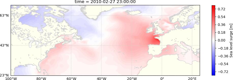
The dataset consists of hourly sea levels and surges over 1900-2015 in the North Atlantic, on a 0.1° grid (directory "HINDCAST" ) and extracted at 34 stations (directory “STATIONS”).
-

Satellite altimetry missions provide a quasi-global synoptic view of sea level over more than 25 years. The satellite altimetry constellation is used to build sea level maps and regional sea level indicators such as trends and accelerations. Estimating realistic uncertainties on these quantities is crucial to address some current climate science questions such as climate change detection and attribution or regional sea level budget closure for example. Previous studies have estimated the uncertainty for the global mean sea level (GMSL), but no uncertainty information is available at regional scales. In this study we estimate a regional satellite altimetry error budget and use it to derive maps of confidence intervals for local sea rise rates and accelerations. We analyze 27 years of satellite altimetry maps and derive the satellite altimetry error variance-covariance matrix at each grid point, prior to the estimation of confidence intervals on local trends and accelerations at the 90% confidence level using extended least squares estimators. Over 1993–2019, we find that the average local sea level trend uncertainty is 0.83 mm.yr-1 with local values ranging from 0.78 to 1.22 mm.yr-1. For accelerations, uncertainties range from 0.057 to 0.12 mm.yr-2, with a mean value of 0.063 mm.yr-2. Change history: - 2020/07/08: initial dataset submission over 1993-2018 - 2020/10/21: 1993-2019 update and addition of error levels
-

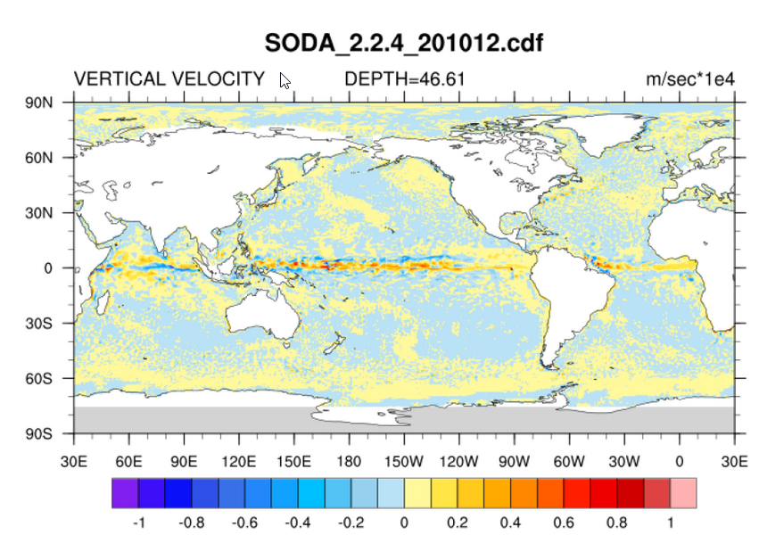
There are several versions of SODA (Carton, Giese and Grodsky, 2005), depending on the experiment setup. Version 2.2.4 represents their first assimilation run of over 100 years and uses the 20Crv2 winds. As such it is considered a "beta release" and is currently under evaluation in preparation of another long run. We are releasing it as we feel it is important for other researchers to have a chance to examine it. Please feel free to contact the SODA group at Texas A&M University with any comments or concerns.
-

Global mean sea level is an integral of changes occurring in the climate system in response to unforced climate variability as well as natural and anthropogenic forcing factors. Its temporal evolution allows detecting changes (e.g., acceleration) in one or more components. Study of the sea level budget provides constraints on missing or poorly known contributions, such as the unsurveyed deep ocean or the still uncertain land water component. In the context of the World Climate Research Programme Grand Challenge entitled “Regional Sea Level and Coastal Impacts”, an international effort involving the sea level community worldwide has been recently initiated with the objective of assessing the various data sets used to estimate components of the sea level budget during the altimetry era (1993 to present). These data sets are based on the combination of a broad range of space-based and in situ observations, model estimates and algorithms. Evaluating their quality, quantifying uncertainties and identifying sources of discrepancies between component estimates is extremely useful for various applications in climate research. This effort involves several tens of scientists from about sixty research teams/institutions worldwide (www.wcrp-climate.org/grand-challenges/gc-sea-level). The results presented in this paper are a synthesis of the first assessment performed during 2017-2018. We present estimates of the altimetry-based global mean sea level (average rate of 3.1 +/- 0.3 mm/yr and acceleration of 0.1 mm/yr2 over 1993-present), as well as of the different components of the sea level budget. We further examine closure of the sea level budget, comparing the observed global mean sea level with the sum of components. Ocean thermal expansion, glaciers, Greenland and Antarctica contribute by 42%, 21%, 15% and 8% to the global mean sea level over the 1993-present. We also study the sea level budget over 2005-present, using GRACE-based ocean mass estimates instead of sum of individual mass components. Results show closure of the sea level budget within 0.3 mm/yr. Substantial uncertainty remains for the land water storage component, as shown in examining individual mass contributions to sea level.
-
 Catalogue PIGMA