 Catalogue PIGMA
sea water temperature
Type of resources
Available actions
Topics
Keywords
Contact for the resource
Provided by
Years
Formats
Representation types
Update frequencies
status
Scale
-

The observations of campe glider on imedia deployment (Mediterranean Sea - Western basin) are distributed in 4 files: - EGO NetCDF time-series (data, metadata, derived sea water current) - NetCDF profiles extracted from the above time-series - Raw data - JSON metadata used by the decoder The following parameters are provided : - Practical salinity - Sea temperature in-situ ITS-90 scale - Electrical conductivity - Sea water pressure, equals 0 at sea-level
-
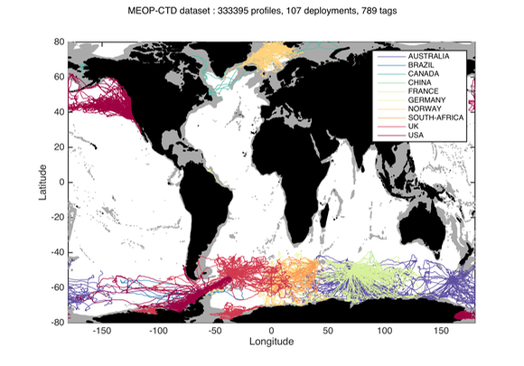
Since 2004, several hundred seals have been equipped with conductivity-temperature-depth (CTD) sensors in the Southern Ocean for both biological and physical oceanographic studies. A calibrated collection of seal-derived hydrographic data is now available from Coriolis, currently consisting of more than 300,000 temperature/salinity profiles. Delayed mode data, December 2014 https://doi.org/10.12770/0a82d60c-683d-47b8-8bd1-24933ec24983 on the Coriolis ftp server, in /ifremer/marine_mammals/. In a near future (summer 2015), seal data will be updated daily, and a monthly snapshot of the full database will be produced. through the Coriolis data selection tool (Sea mammal or Animal profiles).
-
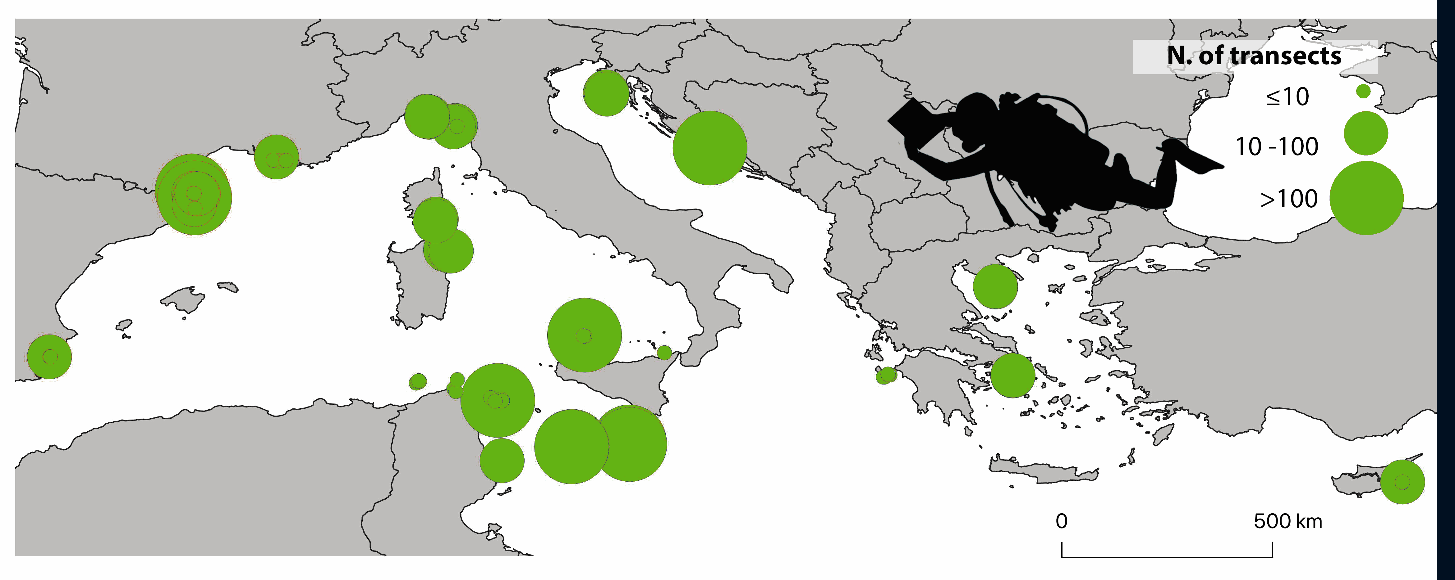
The ClimateFish database collates abundance data of 15 fish species proposed as candidate indicators of climate change in the Mediterranean Sea. An initial group of eight Mediterranean indigenous species (Epinephelus marginatus, Thalassoma pavo, Sparisoma cretense, Coris julis, Sarpa salpa, Serranus scriba, Serranus cabrilla and Caranx crysos) with wide distribution, responsiveness to temperature conditions and easy identification were selected by a network of Mediterranean scientists joined under the CIESM programme ‘Tropical Signals’ (https://www.ciesm.org/marine/programs/tropicalization.htm; Azzurro et al. 2010). Soon after, and thanks to the discussion with other expert groups and projects, C. crysos was no longer considered, and Lessepsian fishes (Red Sea species entering the Mediterranean through the Suez Canal) were included, namely: Fistularia commersonii, Siganus luridus, Siganus rivulatus, Pterois miles, Stephanolopis diaspros, Parupeneus forskali, Pempheris rhomboidea and Torquigener flavimaculosus. Considering the trend of increase of these species in the Mediterranean Sea (Golani et al. 2021) and their projected distribution according to climate change scenarios (D’Amen and Azzurro, 2020), more data on these tropical invaders are expected to come in the future implementation of the study. Data were collected according to a simplified visual census methodology (Garrabou et al. 2019) along standard transects of five minutes performed at a constant speed of 10m/min, corresponding approximately to an area of 50x5m. Four different depth layers were surveyed: 0-3m, 5-10 m, 11-20 m, 21-30 m. So far, the ClimateFish database includes fish counts collected along 3142 transects carried out in seven Mediterranean countries between 2009 and 2021, for a total number of 101'771 observed individuals belonging to the 15 fish species. Data were collected by a large team of researchers which joined in a common monitoring strategy supported by different international projects, which are acknowledged below. This database, when associated with climate data, offers new opportunities to investigate spatio-temporal effects of climate change in the Mediterranean Sea and test the effectiveness of each species as a possible climate change indicator. Contacts: ernesto.azzurro(at)cnr.it References: Azzurro E., Maynou F., Moschella P. (2010). A simplified visual census methodology to detect variability trends of coastal mediterranean fishes under climate change scenarios. Rapp. Comm. int. Mer Médit., 39. D’Amen, M. and Azzurro, E. (2020). Lessepsian fish invasion in Mediterranean marine protected areas: a risk assessment under climate change scenarios. ICES Journal of Marine Science, 77(1), pp.388-397. Garrabou, J., Bensoussan, N., Azzurro, E. (2019). Monitoring climate-related responses in Mediterranean marine protected areas and beyond: five standard protocols. Golani D., Azzurro E., Dulčić J., Massutí E., Orsi-Relini L. (2021). Atlas of Exotic Fishes in the Mediterranean Sea. 2nd edition [F. Briand, Ed.] 365 pages. CIESM Publishers, Paris, Monaco. ISBN number 978-92-990003-5-9
-
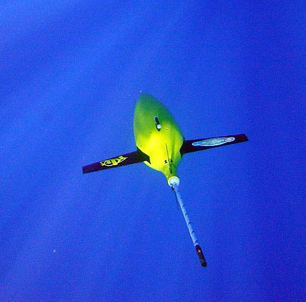
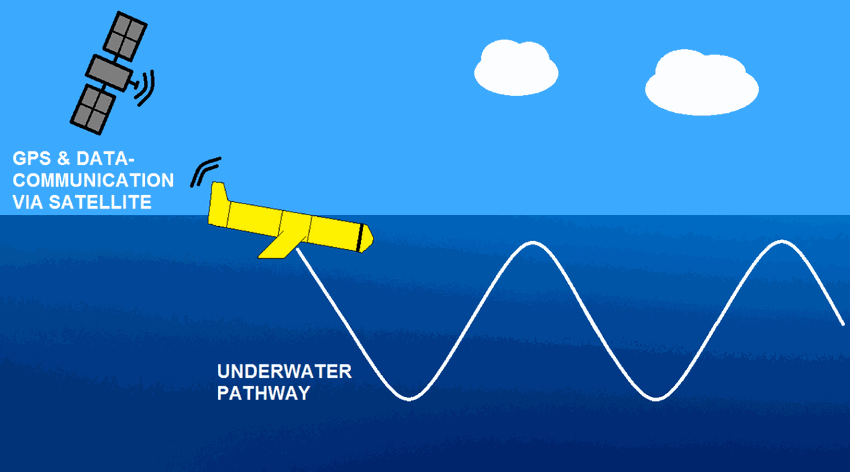
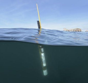
The Everyone's Gliding Observatories (EGO) initiative is a gathering of several teams of oceanographers, interested in developing the use of gliders for ocean observations. EGO started in Europe with members from France, Germany, Italy, Norway, Spain, and the United Kingdom. The partners of EGO have been funded by both European and national agencies to operate gliders for various purposes and at different sites. Coordinated actions are being set up for these sites in order to demonstrate the capabilities of a fleet of gliders for sampling the ocean, with a given scientific and/or operational objective. Gliders were developed since the 90’s to carry out in-situ observations of the upper 1km of the ocean, filling the gaps left by the existing observing systems. Gliders look like small autonomous robotic underwater vehicles which that uses an engine to change their buoyancy. While gliding from surface to about 1000 meters, gliders provide real-time physical and biogeochemical data along their transit. They observe temperature, salinity, pressure, biogeochemical data or acoustic data.
-
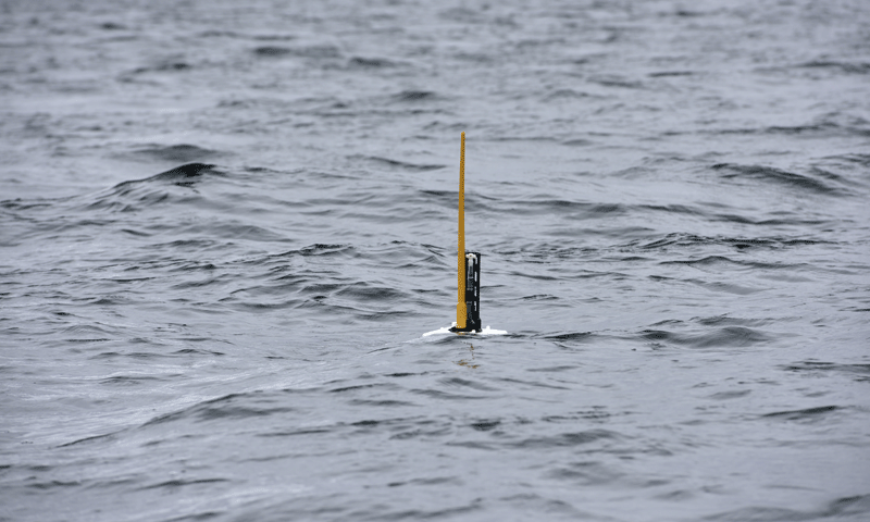
Argo is a global array of 3,000 free-drifting profiling floats that measures the temperature and salinity of the upper 2000 m of the ocean. This allows, for the first time, continuous monitoring of the temperature, salinity, and velocity of the upper ocean, with all data being relayed and made publicly available within hours after collection. The array provides 100,000 temperature/salinity profiles and velocity measurements per year distributed over the global oceans at an average of 3-degree spacing. Some floats provide additional bio-geo parameters such as oxygen or chlorophyll. All data collected by Argo floats are publically available in near real-time via the Global Data Assembly Centers (GDACs) in Brest (France) and Monterey (California) after an automated quality control (QC), and in scientifically quality controlled form, delayed mode data, via the GDACs within six months of collection. The BGC-Argo Sprof snapshot is a subset of the global Argo data snapshot. It is created to ease BGC-Argo data usage. The content is the same if you are to download the global Argo data snapshot, and then select all the BGC-Argo Sprof files. Please use the same DOI and citation as the global Argo data snapshot.
-
The glider operations in the MOOSE network started to be deployed regularly in 2010 in the North Western Mediterranean Sea, thanks to the setup of national glider facilities at DT-INSU/Ifremer (http://www.dt.insu.cnrs.fr/gliders/gliders.php) and with the support of the European project FP7-PERSEUS. Two endurance lines are operated: MooseT00 (Nice-Calvi; Ligurian Sea) and MooseT02 (Marseille-Menorca; Gulf of Lion). The all dataset here corresponds to raw data in the EGO format.
-

The OceanGliders initiative (formerly EGO) is a gathering of several teams of oceanographers, interested in developing the use of gliders for ocean observations. OceanGliders started in Europe with members from France, Germany, Italy, Norway, Spain, and the United Kingdom. The partners of OceanGliders have been funded by both European and national agencies to operate gliders for various purposes and at different sites. Coordinated actions are being set up for these sites in order to demonstrate the capabilities of a fleet of gliders for sampling the ocean, with a given scientific and/or operational objective. Gliders were developed since the 90’s to carry out in-situ observations of the upper 1km of the ocean, filling the gaps left by the existing observing systems. Gliders look like small autonomous robotic underwater vehicles which that uses an engine to change their buoyancy. While gliding from surface to about 1000 meters, gliders provide real-time physical and biogeochemical data along their transit. They observe temperature, salinity, pressure, biogeochemical data or acoustic data. The OceanGliders GDAC handled at Ifremer/France aggregates the data and metadata from glider deployments provided by the DACs or PIs. The OceanGliders unique DOI publishes the quaterly snapshot of the whole GDAC content and preserves its successive quaterly versions (unique DOI for easy citability, preservation of quaterly versions for reproducibility). The OceanGliders unique DOI references all individual glider deployment DOIs provided by the DACs or PIs, and with data in the GDAC. DACs or PIs may use the data processing chain published at http://doi.org/10.17882/45402 to generate glider NetCDF GDAC files.
-
Argo is a global array of 3,000 free-drifting profiling floats that measures the temperature and salinity of the upper 2000 m of the ocean. This allows, for the first time, continuous monitoring of the temperature, salinity, and velocity of the upper ocean, with all data being relayed and made publicly available within hours after collection. The array provides 100,000 temperature/salinity profiles and velocity measurements per year distributed over the global oceans at an average of 3-degree spacing. Some floats provide additional bio-geo parameters such as oxygen or chlorophyll. All data collected by Argo floats are publically available in near real-time via the Global Data Assembly Centers (GDACs) in Brest (France) and Monterey (California) after an automated quality control (QC), and in scientifically quality controlled form, delayed mode data, via the GDACs within six months of collection.