 Catalogue PIGMA
Technical University of Munich, Munich, Germany
Type of resources
Available actions
Topics
Keywords
Contact for the resource
Provided by
Years
Formats
-
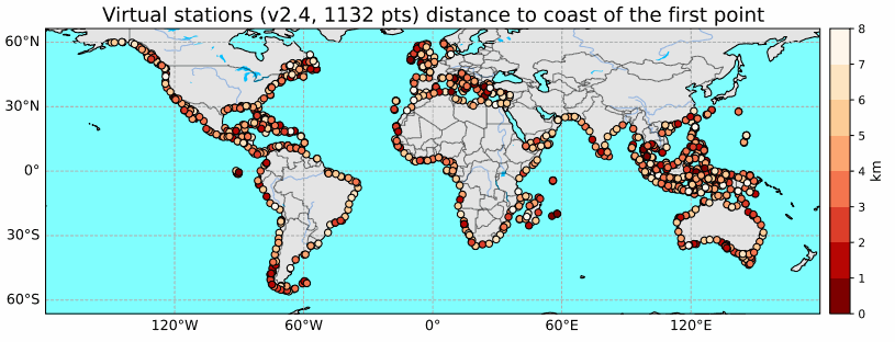
Until recently, classical radar altimetry could not provide reliable sea level data within 10 km to the coast. However dedicated reprocessing of radar waveform together with geophysical corrections adapted for the coastal regions now allows to fill this gap at a large number of coastal sites. In the context of the Climate Change Initiative Sea Level project of the European Space Agency, we have recently performed a complete reprocessing of high resolution (20 Hz, i.e., 350m) along-track altimetry data of the Jason-1, Jason-2 and Jason-3 missions over January 2002 to June 2021 along the coastal zones of Northeast Atlantic, Mediterranean Sea, whole African continent, North Indian Ocean, Southeast Asia, Australia and North and South America. This reprocessing has provided valid sea level data in the 0-20 km band from the coast. More than 1000 altimetry-based virtual coastal stations have been selected and sea level anomalies time series together with associated coastal sea level trends have been computed over the study time span. In the coastal regions devoid from tide gauges (e.g., African coastlines), these virtual stations offer a unique tool for estimating sea level change close to the coast (typically up to 3 km to the coast but in many instances up to 1 km or even closer). Results show that at most of the virtual stations, the rate of sea level rise at the coast is similar to the rate offshore (15 km away from the coast). However, at some stations, the sea level rate in the last 3-4 km to the coast is either faster or slower than offshore.