 Catalogue PIGMA
inlandWaters
Type of resources
Available actions
Topics
Keywords
Contact for the resource
Provided by
Years
Formats
Representation types
Update frequencies
status
Scale
Resolution
-

Maisons éclusières sur les départements de la Gironde et du Lot-et-Garonne.
-

Ensemble résultant du découpage par zones du chenal de navigation.Ces passes sont régulièrement hydrographiées.
-

Centres d'exploitation sur les départements de la Dordogne, Gironde et du Lot-et-Garonne
-
Colloque organise par le Conseil scientifique et culturel du PNR des Landes de Gascogne
-
Le référentiel inondation Gironde (RIG) est un outil d’aide à la décision. Il vise à apporter une connaissance précise des caractéristiques morphologiques du territoire et une modélisation hydraulique des principaux phénomènes dynamiques de crue influençant directement les inondations sur l'estuaire de la Gironde. L'objectif est ainsi de permettre à l’ensemble des partenaires d’orienter des études en vue d’améliorer ou d’optimiser la protection et la gestion des zones inondables du territoire. Le RIG, modèle hydraulique, s'appuie sur un jeu important de données (topographie, bathymétrie, digues, ouvrages, foncier, marégrammes, orientation du vent, etc.).
-

Sites d'écluse sur les départements de la Gironde et du Lot-et-Garonne.
-

Prises d'eau sur les départements de la Gironde et du Lot-et-Garonne.
-

Réseau de Refoulement du réseau d'assainissement collectif de la Communauté d'Agglomération du Bassin de Brive (linéaire).
-
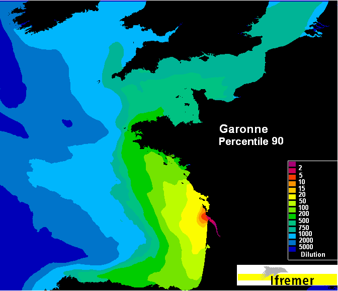
Ces données présentent les panaches statistiques de 45 fleuves français à partir des simulations sur une décennie. La médiane (=percentile 50) et les percentiles 10 et 90 de chaque traceur dans chaque maille ont ainsi été déduits pour la période 2000-2010. Le "bassin récepteur marin" d'un bassin versant est alors défini de façon statistique : le "bassin récepteur médian" correspondra à la répartition géographique de la médiane des concentrations pluriannuelles du traceur, tandis que le "bassin récepteur de crue" correspondra à la répartition du percentile 90 et le "bassin récepteur d'étiage" à la répartition du percentile 10. Ces 3 types de "bassin récepteur" statistique sont présentés sous la forme de cartes représentant les percentiles correspondants.
-
Au niveau national 122 territoires ont été identifié par le ministère de l’Environnement comme étant à risque important d’inondation (TRI). Dans le cadre de la directive inondations la France s’est engagé vis-à-vis de la Commission Européenne à améliorer la gestion des inondations sur ces territoires. Dans le cadre de la directive un cartographie des surfaces inondables et des risques d'inondation a été réalisée sur chaque TRI pour trois fréquences d’évènement (en général la trentennale, la centennale et la millénale).